Zeita Jamma'in
| زيتا جمّاعين |
|
|
| Localització |
|---|
 | | 32° 08′ N, 35° 11′ E / 32.13°N,35.18°E / 32.13; 35.18 |
|
|
| Vila |
| Graella palestina | 167/171 |
|---|
| |
| Organització política |
|---|
| Governació | Nablus |
|---|
|
|
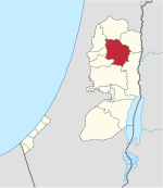
Zeita Jamma'in (àrab: زيتا جمّاعين, Zaytā Jammāʿīn) és un vila palestina de la governació de Nablus, a Cisjordània, al nord de la vall del Jordà, 16 kilòmetres al sud-est de Nablus. Segons l'Oficina Central Palestina d'Estadístiques tenia 1.962 habitants en 2006.[1]
Història
Segons el cens de Palestina de 1931, ordenat per les autoritats del Mandat Britànic de Palestina, Zeita tenia 113 cases ocupades i una població de 404 musulmans i 1 cristià.[2]
Referències
Bibliografia
- Barron, J. B.. Palestine: Report and General Abstracts of the Census of 1922. Government of Palestine, 1923.
- Conder, Claude Reignier; Kitchener, H.H.. The Survey of Western Palestine: Memoirs of the Topography, Orography, Hydrography, and Archaeology. 2. Londres: Committee of the Palestine Exploration Fund, 1882. (p. 287)
- Dauphin, Claudine. La Palestine byzantine, Peuplement et Populations (en francès). III : Catalogue. Oxford: Archeopress, 1998. ISBN 0-860549-05-4. (p. 805)
- Department of Statistics. Village Statistics, April, 1945. Government of Palestine, 1945. (p. 19)
- Finkelstein, I.; Lederman, Zvi. Highlands of many cultures. Tel Aviv: Institute of Archaeology of Tel Aviv University Publications Section, 1997. ISBN 965-440-007-3. (II p. 496)
- Guérin, V. Description Géographique Historique et Archéologique de la Palestine (en francès). 2: Samarie, pt. 2. París: L'Imprimerie Nationale, 1875. (p. 173)
- Hadawi, S.. Village Statistics of 1945: A Classification of Land and Area ownership in Palestine. Palestine Liberation Organization Research Center, 1970.
- Hütteroth, Wolf-Dieter; Abdulfattah, Kamal. Historical Geography of Palestine, Transjordan and Southern Syria in the Late 16th Century. Erlanger Geographische Arbeiten, Sonderband 5. Erlangen, Germany: Vorstand der Fränkischen Geographischen Gesellschaft, 1977. ISBN 3-920405-41-2. (p. 131)
- Mills, E.. Census of Palestine 1931. Population of Villages, Towns and Administrative Areas. Jerusalem: Government of Palestine, 1932.
- Palmer, E.H.. The Survey of Western Palestine: Arabic and English Name Lists Collected During the Survey by Lieutenants Conder and Kitchener, R. E. Transliterated and Explained by E.H. Palmer. Committee of the Palestine Exploration Fund, 1881. (p. 250)
Enllaços externs
|
|---|
| Ciutats | | |
|---|
| Municipis | |
|---|
| Viles | |
|---|
Camps
de refugiats | |
|---|