Ar-Rutba District
District in Al Anbar Governorate, Iraq
Ar-Rutba District قضاء الرطبة | |
|---|---|
District | |
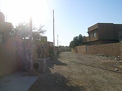 Street scene in Ar-Rutba town (2004) Ar-Rutba is the largest, southernmost and westernmost of the districts in Al Anbar Governorate | |
 | |
| Coordinates: 33°2′17″N 40°17′4″E / 33.03806°N 40.28444°E / 33.03806; 40.28444 | |
| Country |  Iraq Iraq |
| Governorates | Al Anbar Governorate |
| Seat | Ar-Rutba |
| Area | |
| • Total | 93,445 km2 (36,079 sq mi) |
| Population 2018 | |
| • Total | 47,040 |
| • Density | 0.50/km2 (1.3/sq mi) |
| Time zone | UTC+3 (AST) |
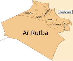
Ar-Rutba District (Arabic: قضاء الرطبة) is the largest district by area in Al Anbar Governorate also the largest in the entirety of Iraq, covering 93,445 km2, and the least populated in relative and absolute terms in Anbar Governorate, with a population of 47,040 or 0.5112 per km2.[1] It is also the southernmost district of Al Anbar Governorate, the westernmost of the whole country, and the only district nationwide bordering Jordan. It is centred on the town of Ar-Rutba.
Towns
- Al Waleed (Al Walid)
- Ar-Rutbah
- Nukhayb
- Trebil
- Akashat
- Al Habbariyah
- Al Kasrah
References
- ^ GeoHive: Iraq population statistics
- v
- t
- e
- Anah District (Anah)
- Fallujah District (Fallujah)
- Haditha District (Haditha)
- Hit District (Hit)
- al-Qa'im District (Al-Qa'im)
- Ramadi District (Ramadi)
- Rawah District (Rawah)
- ar-Rutba District (Ar-Rutbah)

- al-Chibayish District (Al-Chibayish)
- Nasiriyah District (Nasiriyah)
- al-Rifa'i District (Al-Rifa'i)
- al-Shatrah District (Al-Shatrah)
- Suq al-Shuyukh District (Suq Al-Shoyokh)
- Byara District (Byara)
- Halabja District (Halabja)
- Khurmal District (Khurmal)
- Sirwan District (Sirwan)
- Daquq District (Daquq)
- Dibis District (Dibis)
- Hawija District (Hawija)
- Kirkuk District (Kirkuk)
- Ali Al-Gharbi District (Ali Al-Gharbi)
- Amara District (Amarah)
- al-Kahla District (Al-Kahla)
- al-Maimouna District (Al-Maimouna)
- al-Mejar Al-Kabi District (Al-Mejar Al-Kabi)
- Qal'at Saleh District (Qal'at Saleh)
- al-Khidhir District (Al-Khidhir)
- al-Rumaitha District (Al-Rumaitha)
- al-Salman District (Al-Salman)
- al-Samawa District (Samawah)
- Kufa District (Kufa)
- al-Manathera District (Al-Manathera)
- al-Meshkhab District (Al-Meshkhab)
- Najaf District (Najaf)
- Afak District (Afak)
- Diwaniya District (Al Diwaniyah)
- Hamza District (Hamza)
- al-Shamiya District (Al-Shamiya )
- Chamchamal District (Chamchamal)
- Darbandikhan District (Darbandikhan)
- Dokan District (Dokan)
- Kalar District (Kalar)
- Kifri District (Kifri)
- Mawat District (Mawat)
- Penjwen District (Penjwen)
- Pshdar District (Qaladiza)
- Qaradagh District (Qaradagh)
- Ranya District (Ranya)
- Saidsadiq District (Said Sadiq)
- Sharazoor District (Zarayan)
- Sharbazher District (Sharbazher)
- Sulaymaniyah District (Sulaymaniyah)
- Al-Aziziyah District (Al-Aziziyah)
- Badra District (Badra)
- al-Hai District (Al-Hay)
- Kut District (Kut)
- al-Nu'maniya District (Al-Nu'maniya)
- al-Suwaira District (Al-Suwaira)
 | This Iraq geographical location article is a stub. You can help Wikipedia by expanding it. |
- v
- t
- e


