Aurec-sur-Loire
Commune in Auvergne-Rhône-Alpes, France

Coat of arms
Location of Aurec-sur-Loire

(2020–2026) Claude Vial[1]
1
(2021)[2]
43012 /43110
(avg. 432 m or 1,417 ft)
Aurec-sur-Loire (French pronunciation: [oʁɛk syʁ lwaʁ], literally Aurec on Loire; Occitan: Aurec) is a commune in the Haute-Loire department in south-central France.
Population
|
| ||||||||||||||||||||||||||||||||||||||||||||||||||||||||||||||||||||||||||||||||||||||||||||||||||||||||||||||||||
| Source: EHESS[3] and INSEE (1968-2017)[4] | |||||||||||||||||||||||||||||||||||||||||||||||||||||||||||||||||||||||||||||||||||||||||||||||||||||||||||||||||||
Galleries
-
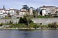 Ramparts.
 -
 Former doorway to the Castle.
 -
 North face
 -
 Tower of the Burgundians.
 -
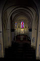 Nave.
Nave. -
 Baptismal Fonts
 -
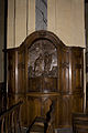
 Altar and altarpiece.
 -
 Pieta.
 -
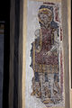
 St. Peter.
 -
 St. Michael.


See also
References
- ^ "Répertoire national des élus: les maires". data.gouv.fr, Plateforme ouverte des données publiques françaises (in French). 2 December 2020.
- ^ "Populations légales 2021" (in French). The National Institute of Statistics and Economic Studies. 28 December 2023.
- ^ Des villages de Cassini aux communes d'aujourd'hui: Commune data sheet Aurec-sur-Loire, EHESS (in French).
- ^ Population en historique depuis 1968, INSEE
Wikimedia Commons has media related to Aurec-sur-Loire.
- v
- t
- e
Communes of the Haute-Loire department 

- Agnat
- Aiguilhe
- Allègre
- Alleyrac
- Alleyras
- Ally
- Araules
- Arlempdes
- Arlet
- Arsac-en-Velay
- Aubazat
- Aurec-sur-Loire
- Autrac
- Auvers
- Auzon
- Azérat
- Bains
- Barges
- Bas-en-Basset
- Beaulieu
- Beaumont
- Beaune-sur-Arzon
- Beaux
- Beauzac
- Bellevue-la-Montagne
- Berbezit
- Bessamorel
- La Besseyre-Saint-Mary
- Blanzac
- Blassac
- Blavozy
- Blesle
- Boisset
- Bonneval
- Borne
- Le Bouchet-Saint-Nicolas
- Bournoncle-Saint-Pierre
- Le Brignon
- Brioudesubpr
- Brives-Charensac
- Cayres
- Céaux-d'Allègre
- Cerzat
- Ceyssac
- Chadrac
- Chadron
- La Chaise-Dieu
- Chamalières-sur-Loire
- Chambezon
- Le Chambon-sur-Lignon
- Champagnac-le-Vieux
- Champclause
- Chanaleilles
- Chaniat
- Chanteuges
- La Chapelle-Bertin
- La Chapelle-d'Aurec
- La Chapelle-Geneste
- Charraix
- Chaspinhac
- Chaspuzac
- Chassagnes
- Chassignolles
- Chastel
- Chaudeyrolles
- Chavaniac-Lafayette
- Chazelles
- Chenereilles
- Chilhac
- Chomelix
- La Chomette
- Cistrières
- Cohade
- Collat
- Connangles
- Costaros
- Coubon
- Couteuges
- Craponne-sur-Arzon
- Cronce
- Cubelles
- Cussac-sur-Loire
- Desges
- Domeyrat
- Dunières
- Espalem
- Espaly-Saint-Marcel
- Esplantas-Vazeilles
- Les Estables
- Fay-sur-Lignon
- Félines
- Ferrussac
- Fix-Saint-Geneys
- Fontannes
- Freycenet-la-Cuche
- Freycenet-la-Tour
- Frugerès-les-Mines
- Frugières-le-Pin
- Goudet
- Grazac
- Grenier-Montgon
- Grèzes
- Javaugues
- Jax
- Josat
- Jullianges
- Lafarre
- Lamothe
- Landos
- Langeac
- Lantriac
- Lapte
- Laussonne
- Laval-sur-Doulon
- Lavaudieu
- Lavoûte-Chilhac
- Lavoûte-sur-Loire
- Lempdes-sur-Allagnon
- Léotoing
- Lissac
- Lorlanges
- Loudes
- Lubilhac
- Malrevers
- Malvalette
- Malvières
- Le Mas-de-Tence
- Mazerat-Aurouze
- Mazet-Saint-Voy
- Mazeyrat-d'Allier
- Mercœur
- Mézères
- Le Monastier-sur-Gazeille
- Monistrol-d'Allier
- Monistrol-sur-Loire
- Monlet
- Montclard
- Le Monteil
- Montfaucon-en-Velay
- Montregard
- Montusclat
- Moudeyres
- Ouides
- Paulhac
- Paulhaguet
- Pébrac
- Le Pertuis
- Pinols
- Polignac
- Pont-Salomon
- Pradelles
- Prades
- Présailles
- Le Puy-en-Velaypref
- Queyrières
- Raucoules
- Rauret
- Retournac
- Riotord
- Roche-en-Régnier
- Rosières
- Saint-André-de-Chalencon
- Saint-Arcons-d'Allier
- Saint-Arcons-de-Barges
- Saint-Austremoine
- Saint-Beauzire
- Saint-Bérain
- Saint-Bonnet-le-Froid
- Saint-Christophe-d'Allier
- Saint-Christophe-sur-Dolaison
- Saint-Cirgues
- Saint-Didier-en-Velay
- Saint-Didier-sur-Doulon
- Sainte-Eugénie-de-Villeneuve
- Sainte-Florine
- Sainte-Marguerite
- Sainte-Sigolène
- Saint-Étienne-du-Vigan
- Saint-Étienne-Lardeyrol
- Saint-Étienne-sur-Blesle
- Saint-Ferréol-d'Auroure
- Saint-Front
- Saint-Geneys-près-Saint-Paulien
- Saint-Georges-d'Aurac
- Saint-Georges-Lagricol
- Saint-Germain-Laprade
- Saint-Géron
- Saint-Haon
- Saint-Hilaire
- Saint-Hostien
- Saint-Ilpize
- Saint-Jean-d'Aubrigoux
- Saint-Jean-de-Nay
- Saint-Jean-Lachalm
- Saint-Jeures
- Saint-Julien-Chapteuil
- Saint-Julien-d'Ance
- Saint-Julien-des-Chazes
- Saint-Julien-du-Pinet
- Saint-Julien-Molhesabate
- Saint-Just-Malmont
- Saint-Just-près-Brioude
- Saint-Laurent-Chabreuges
- Saint-Martin-de-Fugères
- Saint-Maurice-de-Lignon
- Saint-Pal-de-Chalencon
- Saint-Pal-de-Mons
- Saint-Pal-de-Senouire
- Saint-Paul-de-Tartas
- Saint-Paulien
- Saint-Pierre-du-Champ
- Saint-Pierre-Eynac
- Saint-Préjet-Armandon
- Saint-Préjet-d'Allier
- Saint-Privat-d'Allier
- Saint-Privat-du-Dragon
- Saint-Romain-Lachalm
- Saint-Vénérand
- Saint-Vert
- Saint-Victor-Malescours
- Saint-Victor-sur-Arlanc
- Saint-Vidal
- Saint-Vincent
- Salettes
- Salzuit
- Sanssac-l'Église
- Saugues
- La Séauve-sur-Semène
- Sembadel
- Séneujols
- Siaugues-Sainte-Marie
- Solignac-sous-Roche
- Solignac-sur-Loire
- Tailhac
- Tence
- Thoras
- Tiranges
- Torsiac
- Valprivas
- Vals-le-Chastel
- Vals-près-le-Puy
- Varennes-Saint-Honorat
- Les Vastres
- Vazeilles-Limandre
- Venteuges
- Vergezac
- Vergongheon
- Vernassal
- Le Vernet
- Vézézoux
- Vieille-Brioude
- Vielprat
- Villeneuve-d'Allier
- Les Villettes
- Vissac-Auteyrac
- Vorey
- Yssingeauxsubpr
- pref: prefecture
- subpr: subprefecture
Authority control databases | |
|---|---|
| International |
|
| National |
|
 | This Haute-Loire geographical article is a stub. You can help Wikipedia by expanding it. |
- v
- t
- e


