BR-080 (Brazil highway)
 | |
|---|---|
 | |
 BR-080 in Goiás | |
| Route information | |
| Length | 623.8 km (387.6 mi) |
| Major junctions | |
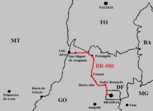
| North end | São Miguel do Araguaia, Goiás |
| South end | Brasília, Distrito Federal |
| Location | |
| Country | Brazil |
| Highway system | |
BR-080 is a federal highway of Brazil.[1] The road was originally planned to connect Brasilia to São Gabriel da Cachoeira in Amazonas state near the Colombian border, an extent of 3,250 km (2,020 mi). Currently, however, it only reaches about 569 km (354 mi) to Luiz Alves, in the city of São Miguel do Araguaia in Goiás, on the border with Mato Grosso.[2]
References
- v
- t
- e

- 010 (Rodovia Engenheiro Bernardo Sayão)
- 020
- 030
- 040
- 050
- 060
- 070
- 080
- 090
- 101 (Translitorânea/Rodovia Governador Mário Covas)
- 104
- 110
- 116 (Rodovia Presidente Dutra)
- 120
- 122
- 135
- 146
- 153 (Rodovia Transbrasiliana)
- 154
- 156
- 158
- 163
- 174
- 210
- 222
- 226
- 230
- 232
- 235
- 242
- 251
- 259
- 262
- 265
- 267
- 272
- 277
- 280
- 282
- 283
- 285
- 287 (Rodovia da Integração)
- 290 (Rodovia Osvaldo Aranha)
- 293
- 304
- 307
- 308
- 316
- 317
- 319
- 324
- 330
- 342
- 343
- 349
- 352
- 354
- 356
- 359
- 361
- 363
- 364
- 365
- 367
- 369
- 373
- 374
- 376
- 377
- 381 (Rodovia Fernão Dias)
- 383
- 386
- 392
- 393
- 401
- 402
- 403
- 404
- 405
- 406
- 407
- 408
- 409
- 410
- 411
- 412
- 413
- 414
- 415
- 416
- 417
- 418
- 419
- 420
- 421
- 422
- 423
- 424
- 425
- 426
- 427
- 428
- 429
- 430
- 431
- 432
- 433
- 434
- 437
- 448
- 450
- 451
- 452
- 453 (Rota do Sol)
- 454
- 455
- 456
- 457
- 458
- 459
- 460
- 461
- 462
- 463
- 464
- 465
- 466
- 467
- 468
- 469
- 470
- 471
- 472
- 473
- 474
- 475
- 476
- 477
- 478
- 479
- 480
- 481
- 482
- 483
- 484
- 485
- 486
- 487
- 488
- 489
- 490
- 491
- 492
- 493
- 494
- 495
- 496
- 497
- 498
- 499
- 600
- 610
  | This article about the roads and road transport of Brazil is a stub. You can help Wikipedia by expanding it. |
- v
- t
- e


