Central Gardens Nature Reserve
33°49′52″S 150°57′45″E / 33.83111°S 150.96250°E / -33.83111; 150.96250
- Adventure playgrounds
- Animal enclosures
- Educational bush trails
- Ponds and water features
- Amphitheatre
- Tennis court
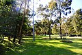
- Large open space grass areas
- BBQ and picnic areas
The Central Gardens Nature Reserve, also called Central Gardens, is a protected nature reserve located in the western suburbs of Sydney, New South Wales, Australia. Established in 1976, the 12-hectare (30-acre) reserve, garden and fauna and wildlife park is situated in the suburb of Merrylands and is managed by Cumberland Council. The park is regionally important and it attracts visitors outside the Cumberland local government area. The bushland contains remnants of Cumberland Plain Woodland and is approximately 3.5 hectares (8.6 acres).[1][2]
History
Before opening, the area was first used for clay extraction pits and kilns for brick making in the 1970s. The design of the park began at that time, with the tennis courts and grass area developed. The reserve was officially opened on 12 April 1976 by The Hon Tom Uren, the Deputy Leader of the Opposition at that time. Many trees were lost in the park as a result of a severe storm in February 2002. The boardwalk and deck structure was built in 1993, which was designed to allow disabled persons to access the edge of the main lake.[3]
Geography

The reserve is located between Merrylands Road, Paton Street and the Cumberland Highway in Merrylands. The park's landform is made up of two main topographic regions — The northern half slopes gently from Merrylands Road towards the system of lakes in the centre of the park, whilst the section of park's south of the lakes is largely flat, with a small localised rise in elevation opposite of Paton St.
Water is pumped from the main lake to an outlet near the Cumberland Highway. The quality of the lake is rather poor. Factors include silt laden runoff entering from adjacent areas, shallow waters, presence of marine animals and lack of reliable water supply to fill the lakes up during dry periods.[4]
Flora
The vegetation of the gardens generally consist of a mixture of remnant indigenous vegetation and planted trees. The most significant area of remnant vegetation, known as Central Gardens Woodland, is located in the northwest corner of the park adjacent to the Cumberland Highway. The Woodland of the park is isolated from other significant areas of vegetation in the region.
A total of 78 native plant species have been observed in the reserve. The Reserve has vegetation species such as Bursaria spinosa, Eucalyptus moluccana, Melaleuca decora, Exocarpos cupressiformis, Lomandra filiformis, Grey Box, Eucalyptus crebra (Narrow-leafed Ironbark), Eucalyptus tereticornis (Forest Red Gum), Bursaria spinosa (Blackthorn), Dillwynia juniperina (Prickly Parrot-pea), Casuarina glauca (Swamp Oak) and Themeda australis. Exotic species include Ulmus parvifolia (Chinese Elm) and Liquidambar styraciflua (Sweet Gum).[5]
Fauna
Some of the animals in the park include kangaroos and wallabies, Australian white ibis, emus, waterfowl, wombats, and native birds, including cockatoos and cockatiels. Carps are found in the ponds, and also duck species such as the Pacific black duck, black swan, Emden goose, dusky moorhen and the Australian wood duck. The main habitat area within the gardens is the tree canopy, which is used by a range of bird species.[6]
Features
The natural bushland features walking tracks, boardwalk, kiosk, amphitheatre, fountains, ornamental lake system, bird and animal enclosures (fauna and aviary), also sports ground such as tennis courts and open fields. The reserve is a popular venue for wedding photos and company picnics. Yarrabee and Pinaroo areas may be hired for those large family or company picnics. Other features include hot water tank, sink, toilets, BBQs, picnic tables and dozens of shady trees. Concrete paths meander throughout the park.
The lake's water jets help with water aeration, whilst also providing a visual and auditory perspective. A major attribute of the reserve is the exposed sandstone rock face, formed during quarrying operations, when the site was used for brick making. Part of this cliff is used for a large (artificial) waterfall and is a conspicuous attraction in the park.[7]
Demographics
The 1989 survey indicated that the most popular form of recreation in the park was picnicking and barbequing (62%), with relaxing also a favoured activity (55%). 83% of visitors to the park arrive by car and 15% of visitors by foot. Peak times for visitation occurred between 12 noon and 2pm. The survey found that 56.7% of park users were not residents of the Cumberland local government area.[8]
Access
Bookings, which go through Cumberland Council, are required in order to access the tennis courts. Entry is free. Wheelchair access is available. Restricted access areas include the fenced woodland area, the animal enclosures and the works depot. The park is closed on Christmas Day and Good Friday.
Gallery
-
 The aviary cage
 -
 The fauna reserve with wallabies
 -
 Grass and wood area
 -
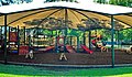 The park's playground
 -
 Dusky moorhens in a lake


See also
 New South Wales portal
 Environment portal


- Auburn Botanical Gardens
- List of parks in Sydney
- Nurragingy Reserve
- Prospect Nature Reserve
- Protected areas of New South Wales
- Western Sydney Parklands
- Wetherill Park Nature Reserve
References
- ^ a b "Central Gardens Nature Reserve". Your facilities. Cumberland Council. n.d. Retrieved 12 January 2020.
- ^ "Finlaysons Creek Corridor, Cumberland Plain Corridor: Existing Conditions and Opportunities". Green Corridors Management Strategy Part 5: Green Corridors Inventory. Upper Parramatta River Catchment Trust. Archived from the original on 21 June 2014. Retrieved 19 September 2014.
- ^ "Central Gardens Merrylands West: Regeneration and Interpretation Project" (PDF). Greener Corridors: An Action Plan and Report Card on the Green Corridors Implementation Program (PDF). Upper Parramatta River Catchment Trust. Archived from the original (PDF) on 21 June 2014. Retrieved 19 September 2014.
- ^ Benson, D.; McDougall, L. (1991). Rare Bushland Plants of Western Sydney. Royal Botanic Gardens, Sydney.
- ^ Robinson, L. (1991). Field Guide to the Native Plants of Sydney. Sydney: Kangaroo Press.
- ^ James, T. A. (1994). The Botanical Significance of the Lower Canal, Greystanes (Unpublished ed.). Royal Botanical Gardens, Sydney.
- ^ "FT8 - Central Gardens" (PDF) (PDF). OZ green. September 2002. Archived from the original (PDF) on 16 March 2015. Retrieved 7 November 2014.
- ^ A. Bernhard & Associates (1995). Greystanes Creek Reserves Plan of Management.
{{cite book}}:|work=ignored (help)
- v
- t
- e
Sydney landmarks
- Admiralty House
- Archibald Fountain
- Australia Square
- Bankstown Reservoir
- Boothtown Aqueduct
- Cadmans Cottage
- Campbell's Stores
- The Cenotaph
- Central station
- Chifley Tower
- Citigroup Centre
- International Convention Centre
- Deutsche Bank Place
- Dr Chau Chak Wing Building
- El Alamein Fountain
- Finger Wharf
- General Post Office (No. 1 Martin Place)
- Government House
- Governor Phillip Tower
- Hong Kong House
- Hyde Park Barracks
- King Street Wharf
- Kirribilli House
- Long Bay
- Macquarie Lighthouse
- Mint
- Observatory
- Old Government House
- Old Mining Museum Building
- Opera House
- Overseas Passenger Terminal
- Parliament House
- Parramatta Gaol
- Regimental Square
- The Ribbon
- Queen Victoria Building
- St Andrew's Cathedral
- St Mary's Cathedral
- Sydney Airport
- Sydney Tower
- The Toaster
- Town Hall
- War Memorial
- Warragamba Dam
- White Bay Cruise Terminal
- World Square
- World Tower
- Auburn Botanic Gardens
- Balaka Falls
- Balls Head Reserve
- Bents Basin
- Berowra Valley National Park
- Bicentennial Park
- Bland Oak
- Blue Mountains National Park
- Brenan Park
- Centennial Parklands
- Central Gardens Nature Reserve
- Chinese Garden of Friendship
- Chipping Norton Lake
- Cronulla sand dunes
- Fairfield Park Precinct
- Farm Cove
- Featherdale Wildlife Park
- Field of Mars Reserve
- Fred Hollows Reserve
- Garigal National Park
- Garawarra Conservation Area
- Georges River National Park
- Heathcote National Park
- Hyde Park
- Kamay Botany Bay National Park
- Ku-ring-gai Chase
- Lake Parramatta
- Lane Cove National Park
- Macquarie Place
- Mrs Macquarie's Chair
- Paddington Reservoir
- Parramatta Park
- Prospect dolerite intrusion
- Prospect Hill
- Prospect Nature Reserve
- Rosford Street Reserve
- Royal Botanic Garden
- Royal National Park
- Sydney Harbour National Park
- Sydney Park
- The Domain
- Western Sydney Parklands
- Western Sydney Regional Park
- Wetherill Park Nature Reserve
- Art Gallery of New South Wales
- Australian Museum
- Australian National Maritime Museum
- Chau Chak Wing Museum
- Harry's Cafe de Wheels
- Manly Art Gallery and Museum
- Museum of Contemporary Art
- Museum of Sydney
- Justice and Police Museum
- Powerhouse Museum
- Sea Life Sydney Aquarium
- State Library
- Sydney Conservatorium of Music
- Sydney Zoo
- Taronga Zoo
- Australian Golf Club
- Canterbury Park Racecourse
- Dunc Gray Velodrome
- Lakes Golf Club
- Macquarie Ice Rink
- Randwick Racecourse
- Rosehill Gardens Racecourse
- Royal Sydney Golf Club
- Stadium Australia
- State Sports Centre
- Sydney Cricket Ground
- Sydney Football Stadium
- Sydney International Regatta Centre
- Sydney Motorsport Park
- Sydney Olympic Park
- Sydney Olympic Park Athletic Centre
- Sydney Olympic Park Aquatic Centre
- Sydney Olympic Park Hockey Centre
- Sydney Olympic Park Tennis Centre
- Sydney Showground Stadium
- Warwick Farm Racecourse
- Wentworth Park
- Western Sydney International Dragway
- Western Sydney Stadium
- Bare
- Clark
- Cockatoo
- Fort Denison
- Garden
- Goat
- Rodd
- Shark
- Snapper
- Spectacle


