Drwinka
You can help expand this article with text translated from the corresponding article in Polish. (October 2011) Click [show] for important translation instructions.
- View a machine-translated version of the Polish article.
- Machine translation, like DeepL or Google Translate, is a useful starting point for translations, but translators must revise errors as necessary and confirm that the translation is accurate, rather than simply copy-pasting machine-translated text into the English Wikipedia.
- Do not translate text that appears unreliable or low-quality. If possible, verify the text with references provided in the foreign-language article.
- You must provide copyright attribution in the edit summary accompanying your translation by providing an interlanguage link to the source of your translation. A model attribution edit summary is
Content in this edit is translated from the existing Polish Wikipedia article at [[:pl:Drwinka]]; see its history for attribution. - You may also add the template
{{Translated|pl|Drwinka}}to the talk page. - For more guidance, see Wikipedia:Translation.
River in Poland

• location
• coordinates
• elevation
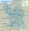
Drwinka is a river, the right bank tributary of the Vistula[3] with a length of 31.05 km (19 mi).[2]
Drwinka flows in the Wieliczka and Bochnia Counties of Lesser Poland Voivodeship from sources near Niepołomice to the mouth in Świniary, 133.5 km (83 km) into the Vistula River. Among its tributaries are streams and ditches from Niepołomice Forest, Wilczy Forest and from near Gawłówek.
The southeastern part of its catchment basin is situated in the sandy area of the Vistula valley, filled mainly with quaternary river sediments covered with loess and sandstones of a dozen or so feet. Here the river passes through the Niepołomice Forest, dividing it into two different flora complexes.
The overall quality assessment of the Drwinka river waters at its estuary in physico-chemical, hydrobiological and bacteriological terms corresponds to Class I or Class II standards.[4] Water in Drwinka does not show signs of eutrophication.[4]
See also
References
- ^ General Geodesic Office of Poland. "Drwinka on the Polish Infrastructure Information map portal". Retrieved 2017-09-01.
- ^ a b National Water Management Board. "Drwinka on the map portal of the National Water Management Board (search result)". Archived from the original on 2017-09-01. Retrieved 2017-09-01.
- ^ General Geodesic Office. "Geographical nomenclature of Poland. Volume 1. Hydronyms. Part 1. Flowing water, springs, waterfalls" (PDF) (in Polish). p. 58. Archived from the original (PDF) on 2019-11-03. Retrieved 2017-09-01.
- ^ a b Regional Conservation Authority in Krakow. "Surface waters assessment of 2015" (PDF) (in Polish). p. 10. Retrieved 20 March 2018.
- v
- t
- e
Tributaries of the Vistula River
- Biała Wisełka
- Czarna Wisełka
- Krajka
- Pszczynka
- Gostynia
- Przemsza
- Chech
- Rudno
- Sanka
- Rudawa
- Prądnik
- Dłubnia
- Roporek
- Szreniawa
- Nidzica
- Nida
- Strumień
- Czarna
- Koprzywianka
- Opatówka
- Kamienna
- Krępianka
- Iłżanka
- Zwoleńka
- Plewka
- Zagożdżonka
- Radomka
- Pilica
- Czarna
- Jeziorka
- Bzura
- Skrwa Lewa
- Zgłowiączka
- Tążyna
- Zielona
- Brda
- Wda
- Wierzyca
- Brennica
- Iłownica
- Biała
- Soła
- Skawa
- Skawinka
- Wilga (Krakow)
- Drwinka
- Raba
- Gróbka
- Uszwica
- Kisielina
- Dunajec
- Breń
- Brnik
- Wisłoka
- Babulówka
- Trześniówka
- Łęg
- San
- Sanna
- Wyżnica
- Chodelka
- Bystra
- Kurówka
- Wieprz
- Okrzejka
- Promnik
- Wilga (Garwolin)
- Świder
- Kanał Żerański
- Narew
- Mołtawa
- Słupianka
- Rosica
- Brzeźnica
- Skrwa Prawa
- Mień
- Drwęca
- Bacha
- Struga
- Osa
- Liwa
- Mała Wisełka (Polska Wisła)
- Nogat
- Leniwka
- Szkarpawa
- Vistula Lagoon
- Śmiała Wisła
- Martwa Wisła
- Przekop Canal
This article related to a river in Poland is a stub. You can help Wikipedia by expanding it. |
- v
- t
- e


