Dry Fork, West Virginia
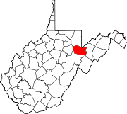
Dry Fork is an unincorporated community in Randolph and Tucker counties, West Virginia, United States. It is located along West Virginia Route 32, 3.5 miles (5.6 km) north-northeast of Harman. Dry Fork has a post office with ZIP code 26263.[3]
The community takes its name from nearby Dry Fork Cheat River.[4] It is near the Dolly Sods Wilderness.
Demographics
2010 census
At the 2010 census there were 781 people, 333 households, and 260 families living in the town. The population density was 6 inhabitants per square mile (2.3/km2). The racial makup of the town was 100% White.[5]
Of the 333 households 34.8% had children under the age of 18 living with them, 65.2% were married couples living together, 6.0% had a female householder with no husband present, 0% had a male householder with no wife present, and 2.4% were non-families. 19.5% of households were one person.
16.9% of residents were under the age of 18; 4.99% were between the ages of 18 and 21; 19.5% were from 22 to 39; 33.5% were from 40 to 64; and 25.1% were 65 or older.
References
- ^ a b U.S. Geological Survey Geographic Names Information System: Dry Fork, West Virginia
- ^ "Population by County Subdivision in ZIP Code 26260". Statistical Atlas. Retrieved March 9, 2021.
- ^ ZIP Code Lookup Archived June 15, 2011, at the Wayback Machine
- ^ Kenny, Hamill (1945). West Virginia Place Names: Their Origin and Meaning, Including the Nomenclature of the Streams and Mountains. Piedmont, WV: The Place Name Press. p. 215.
- ^ "Overview of Dry Fork, Tucker County, West Virginia (District)". Statistical Atlas. Retrieved March 9, 2021.
- v
- t
- e

- Beverly
- Harman
- Huttonsville
- Mill Creek
- Montrose
- Womelsdorf (Coalton)
communities
- Adolph
- Aggregates
- Alpena
- Arnold Hill
- Bemis
- Blue Spring
- Brady Gate
- Bruxton
- Canfield
- Cassity
- Cheat Bridge
- Cubana
- Crystal Springs
- Czar
- Dry Fork
- Elkwater
- Ellamore‡
- Evenwood
- Fairview (near Elkins)
- Fairview (near Helvetia)
- Faulkner
- Flint
- Glady
- Harding
- Hazelwood
- Horton
- Jimtown
- Job
- Kerens
- Lee Bell
- Little Italy
- Loda
- Mabie
- Mingo
- Monterville
- Newlonton
- Pumpkintown
- Read
- Silica
- Spangler
- Sullivan
- Sully
- Suncrest
- Tigheville
- Upper Mingo
- Weaver
- Weese
- Whyte
- Wymer
towns
- West Virginia portal
- United States portal
 | This article about a location in Randolph County, West Virginia is a stub. You can help Wikipedia by expanding it. |
- v
- t
- e


