Gerendás
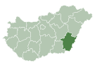
Place in Békés, Hungary

Coat of arms
 Hungary
 (2023)
5925
Gerendás is a village in Békés County, in the Southern Great Plain region of south-east Hungary. The nearest city is Csorvás.[1]
It covers an area of 40.78 km2 and has a population of 1576 people (2002).
- v
- t
- e
- Békéscsaba (county seat)
- Almáskamarás
- Biharugra
- Bucsa
- Békéssámson
- Bélmegyer
- Csabaszabadi
- Csanádapáca
- Csárdaszállás
- Dombiratos
- Ecsegfalva
- Gerendás
- Geszt
- Hunya
- Kamut
- Kardos
- Kardoskút
- Kaszaper
- Kertészsziget
- Kisdombegyház
- Kondoros
- Kunágota
- Kétsoprony
- Körösnagyharsány
- Köröstarcsa
- Körösújfalu
- Kötegyán
- Lőkösháza
- Magyarbánhegyes
- Magyardombegyház
- Medgyesbodzás
- Mezőgyán
- Murony
- Méhkerék
- Nagybánhegyes
- Nagykamarás
- Okány
- Pusztaföldvár
- Pusztaottlaka
- Sarkadkeresztúr
- Szabadkígyós
- Tarhos
- Telekgerendás
- Végegyháza
- Zsadány
- Örménykút
- Újszalonta
- History
- Geography
- Government
- Economy
- Culture
- Tourism
Authority control databases | |
|---|---|
| International |
|
| National |
|
References
- ^ Latitude.to. "GPS coordinates of Gerendás, Hungary. Latitude: 46.5970 Longitude: 20.8600". Latitude.to, maps, geolocated articles, latitude longitude coordinate conversion. Retrieved 2020-09-15.
 | This Békés County location article is a stub. You can help Wikipedia by expanding it. |
- v
- t
- e


