Grade II* listed buildings in South Derbyshire
Map all coordinates using OpenStreetMap
Download coordinates as:
- KML
- GPX (all coordinates)
- GPX (primary coordinates)
- GPX (secondary coordinates)
There are over 20,000 Grade II* listed buildings in England. This page is a list of these buildings in the district of South Derbyshire in Derbyshire.
List of buildings
| Name | Location | Type | Completed [note 1] | Date designated | Grid ref.[note 2] Geo-coordinates | Entry number [note 3] | Image |
|---|---|---|---|---|---|---|---|
| Aston Hall | Aston-on-Trent | Country House | Early 18th century | 10 November 1967 | SK4149829170 52°51′30″N 1°23′06″W / 52.858428°N 1.385118°W / 52.858428; -1.385118 (Aston Hall) | 1096430 | 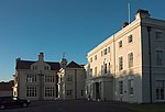 More images |
| Barton Hall | Barton Blount | Country House | 15th century | 2 September 1952 | SK2081934658 52°54′32″N 1°41′31″W / 52.908953°N 1.691885°W / 52.908953; -1.691885 (Barton Hall) | 1096544 |  Upload Photo |
| Bretby Hall | Bretby Park, Bretby | Country House | Early 17th century | 31 October 1985 | SK3001122547 52°47′59″N 1°33′23″W / 52.799653°N 1.556322°W / 52.799653; -1.556322 (Bretby Hall) | 1334588 |  More images |
| Brizlincote Hall Farmhouse | Bretby | Farmhouse | 1707 | 19 January 1967 | SK2727022027 52°47′42″N 1°35′49″W / 52.795124°N 1.597018°W / 52.795124; -1.597018 (Brizlincote Hall Farmhouse) | 1096480 |  More images |
| Deercote west of the Church of St Giles | Calke Park, Calke | Wall | Late 18th century | 6 January 1987 | SK3670922280 52°47′49″N 1°27′25″W / 52.79684°N 1.457013°W / 52.79684; -1.457013 (Deercote west of the Church of St Giles) | 1031806 |  More images |
| Stables and Riding School | Calke Park, Calke | Courtyard | Mid–late 18th century | 19 January 1967 | SK3668322666 52°48′01″N 1°27′26″W / 52.800312°N 1.457355°W / 52.800312; -1.457355 (Stables and Riding School) | 1096488 | 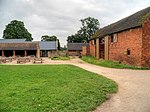 More images |
| Catton Hall | Catton | Country House | 1741 | 2 September 1952 | SK2061315359 52°44′08″N 1°41′46″W / 52.735476°N 1.696159°W / 52.735476; -1.696159 (Catton Hall) | 1334609 | 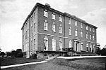 More images |
| Cauldwell Hall | Cauldwell | Country House | Early 18th century | 2 September 1952 | SK2551417173 52°45′06″N 1°37′24″W / 52.751575°N 1.623436°W / 52.751575; -1.623436 (Cauldwell Hall) | 1334612 | Upload Photo |
| Church of All Saints | Dalbury Lees | Parish Church | 13th century | 19 January 1967 | SK2635434282 52°54′19″N 1°36′35″W / 52.905331°N 1.609616°W / 52.905331; -1.609616 (Church of All Saints) | 1334550 | 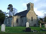 More images |
| Footbridge on former Eggington Estate at SK264277 | Egginton | Footbridge | 1812 | 19 April 1990 | SK2640027700 52°50′46″N 1°36′34″W / 52.846163°N 1.609464°W / 52.846163; -1.609464 (Footbridge on former Eggington Estate at SK264277) | 1140125 | Upload Photo |
| Elvaston Castle | Elvaston | Country House | 1633 | 2 September 1952 | SK4078533004 52°53′35″N 1°23′43″W / 52.892945°N 1.395228°W / 52.892945; -1.395228 (Elvaston Castle) | 1334604 | 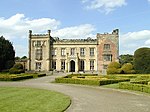 More images |
| Gates, gatepiers, and railings to south of the Etwall Almshouses | Etwall | Gate | Early 18th century | 22 August 1985 | SK2688232038 52°53′06″N 1°36′07″W / 52.885134°N 1.601951°W / 52.885134; -1.601951 (Gates, gatepiers, and railings to south of the Etwall Almshouses) | 1334552 |  |
| Sir John Port Almshouses | Etwall | Almshouse | circa 1690 | 2 September 1952 | SK2687832064 52°53′07″N 1°36′07″W / 52.885368°N 1.602008°W / 52.885368; -1.602008 (Sir John Port Almshouses) | 1096567 |  More images |
| Two sets of gatepiers and walls enclosing churchyard of St Saviours Church | Foremark | Gate | Early 18th century | 19 January 1967 | SK3297426488 52°50′06″N 1°30′43″W / 52.834907°N 1.51198°W / 52.834907; -1.51198 (Two sets of gatepiers and walls enclosing churchyard of St Saviours Church) | 1334572 |  |
| The Manor House | Hartshorne | House | 20th century | 2 September 1952 | SK3269020767 52°47′01″N 1°31′00″W / 52.783497°N 1.516766°W / 52.783497; -1.516766 (The Manor House) | 1281804 |  |
| Ingleby Toft | Ingleby | House | Early 18th century | 19 January 1967 | SK3550526504 52°50′06″N 1°28′28″W / 52.83489°N 1.474411°W / 52.83489; -1.474411 (Ingleby Toft) | 1370039 |  |
| Church of All Saints | Lullington | Parish Church | Late 14th century | 19 January 1967 | SK2498712944 52°42′49″N 1°37′54″W / 52.713583°N 1.631564°W / 52.713583; -1.631564 (Church of All Saints) | 1159003 |  More images |
| Grotto to south-east of the Old Mill in Melbourne Hall gardens | Melbourne | Shell Grotto | Early 19th century | 10 November 1967 | SK3910424843 52°49′11″N 1°25′16″W / 52.819711°N 1.421189°W / 52.819711; -1.421189 (Grotto to south-east of the Old Mill in Melbourne Hall gardens) | 1334617 | Upload Photo |
| Hall Cottages and Stables at Melbourne Hall | Melbourne | House | 16th century | 10 November 1967 | SK3894525025 52°49′17″N 1°25′25″W / 52.821359°N 1.423526°W / 52.821359; -1.423526 (Hall Cottages and Stables at Melbourne Hall) | 1096408 | Upload Photo |
| Melbourne Hall | Melbourne | Country House | circa 1630 | 2 September 1952 | SK3897625010 52°49′16″N 1°25′23″W / 52.821222°N 1.423068°W / 52.821222; -1.423068 (Melbourne Hall) | 1204079 |  More images |
| Pair of curved benches to either side of Grand Basin in Melbourne Hall gardens | Melbourne | Garden Seat | Early 18th century | 11 March 1987 | SK3916424944 52°49′14″N 1°25′13″W / 52.820615°N 1.420286°W / 52.820615; -1.420286 (Pair of curved benches to either side of Grand Basin in Melbourne Hall gardens) | 1096373 | Upload Photo |
| Pair of garden walls flanking top terrace of Melbourne Hall gardens | Melbourne | Garden Wall | circa 1704 | 11 March 1987 | SK3903724949 52°49′14″N 1°25′20″W / 52.820669°N 1.42217°W / 52.820669; -1.42217 (Pair of garden walls flanking top terrace of Melbourne Hall gardens) | 1096410 | Upload Photo |
| Tithe Barn | Melbourne | Malt Kiln | 17th century | 2 September 1952 | SK3887324981 52°49′15″N 1°25′29″W / 52.820969°N 1.4246°W / 52.820969; -1.4246 (Tithe Barn) | 1204539 | Upload Photo |
| Water channel and three bridges in Melbourne Hall gardens | Melbourne | Bridge | Early 18th century | 11 March 1987 | SK3912624926 52°49′14″N 1°25′15″W / 52.820456°N 1.420852°W / 52.820456; -1.420852 (Water channel and three bridges in Melbourne Hall gardens) | 1204519 | Upload Photo |
| Church of St Peter | Netherseal | Parish Church | 13th century | 10 January 1967 | SK2887712890 52°42′46″N 1°34′26″W / 52.712905°N 1.573988°W / 52.712905; -1.573988 (Church of St Peter) | 1334597 | 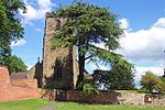 More images |
| Netherseal Old Hall and attached outbuildings and garden walls | Netherseal | House | 1642 | 2 September 1952 | SK2899712892 52°42′47″N 1°34′20″W / 52.712917°N 1.572212°W / 52.712917; -1.572212 (Netherseal Old Hall and attached outbuildings and garden walls) | 1096414 |  |
| Pigeoncote at Old Hall Cottages | Netherseal | Dovecote | 1689 | 19 January 1967 | SK2898512819 52°42′44″N 1°34′21″W / 52.712261°N 1.572396°W / 52.712261; -1.572396 (Pigeoncote at Old Hall Cottages) | 1096418 | Upload Photo |
| Bladon Castle | Newton Solney | Motte | 1801-2 | 19 January 1967 | SK2698925079 52°49′21″N 1°36′03″W / 52.822573°N 1.600934°W / 52.822573; -1.600934 (Bladon Castle) | 1096466 | Upload Photo |
| Church of St Mary the Virgin | Newton Solney | Parish Church | circa 1300 | 19 January 1967 | SK2792425770 52°49′43″N 1°35′13″W / 52.828737°N 1.587001°W / 52.828737; -1.587001 (Church of St Mary the Virgin) | 1334576 | 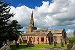 More images |
| Overseal House | Overseal | House | Late 18th century | 19 January 1967 | SK2963714953 52°43′53″N 1°33′45″W / 52.731409°N 1.562553°W / 52.731409; -1.562553 (Overseal House) | 1311162 |  |
| The Grange | Repton | House | 1703 | 2 September 1952 | SK3069326437 52°50′04″N 1°32′45″W / 52.834583°N 1.545843°W / 52.834583; -1.545843 (The Grange) | 1096501 | Upload Photo |
| Church of St Mary | Rosliston | Parish Church | 14th century | 19 January 1967 | SK2433716815 52°44′54″N 1°38′27″W / 52.748411°N 1.6409°W / 52.748411; -1.6409 (Church of St Mary) | 1159242 | 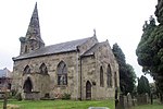 More images |
| Shardlow Hall with attached garden seat to north-east corner, steps c.14m from north-west front and steps c.7m west of south-west corner | Shardlow | Country House | 1684 | 11 March 1987 | SK4384830478 52°52′12″N 1°21′00″W / 52.869999°N 1.350043°W / 52.869999; -1.350043 (Shardlow Hall with attached garden seat to north-east corner, steps c.14m from north-west front and steps c.7m west of south-west corner) | 1088368 |  More images |
| The Lock Up (Round House) | Smisby | Lock Up | Late 18th century | 19 January 1967 | SK3486919083 52°46′06″N 1°29′05″W / 52.768224°N 1.48464°W / 52.768224; -1.48464 (The Lock Up (Round House)) | 1281737 | 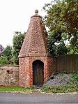 More images |
| Church of St Michael | Sutton on the Hill | Statue | 20th century | 19 January 1967 | SK2374434239 52°54′18″N 1°38′54″W / 52.905066°N 1.648424°W / 52.905066; -1.648424 (Church of St Michael) | 1096581 | 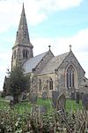 More images |
| Sutton Hall and attached outbuildings | Sutton on the Hill | House | 1952 | 2 September 1952 | SK2363333815 52°54′05″N 1°39′00″W / 52.901259°N 1.650105°W / 52.901259; -1.650105 (Sutton Hall and attached outbuildings) | 1334519 |  |
| Church of St James | Swarkestone | Parish Church | 12th century | 10 November 1967 | SK3719628595 52°51′13″N 1°26′57″W / 52.853573°N 1.449073°W / 52.853573; -1.449073 (Church of St James) | 1088344 |  More images |
| Swarkestone Hall Farmhouse | Swarkestone | Farmhouse | Early 17th century | 2 September 1952 | SK3745528406 52°51′07″N 1°26′43″W / 52.851856°N 1.445249°W / 52.851856; -1.445249 (Swarkestone Hall Farmhouse) | 1088346 |  More images |
| Swarkestone Old Hall and attached walls | Swarkestone | House | 18th century | 10 November 1967 | SK3734328500 52°51′10″N 1°26′49″W / 52.852709°N 1.446901°W / 52.852709; -1.446901 (Swarkestone Old Hall and attached walls) | 1280604 | Upload Photo |
| The Lock-up | Ticknall | Lock Up | Late 18th century | 19 January 1967 | SK3515323908 52°48′42″N 1°28′48″W / 52.811578°N 1.479914°W / 52.811578; -1.479914 (The Lock-up) | 1096445 |  More images |
| The Middle Lodge | Calke Park, Ticknall | Gate Lodge | circa 1805 | 19 January 1967 | SK3573223168 52°48′18″N 1°28′17″W / 52.804888°N 1.471405°W / 52.804888; -1.471405 (The Middle Lodge) | 1203338 |  More images |
| All Saints Church | Trusley | Parish Church | 1713 | 19 January 1967 | SK2535735533 52°55′00″N 1°37′28″W / 52.916625°N 1.624342°W / 52.916625; -1.624342 (All Saints Church) | 1281370 | 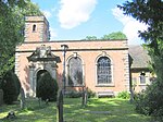 More images |
| Old Hall Cottage | Twyford | House | 16th century | 19 January 1967 | SK3291128928 52°51′25″N 1°30′46″W / 52.856844°N 1.51267°W / 52.856844; -1.51267 (Old Hall Cottage) | 1096517 |  |
| Church of St Laurence | Walton-on-Trent | Statue | 20th century | 19 January 1967 | SK2158918230 52°45′40″N 1°40′53″W / 52.761247°N 1.681517°W / 52.761247; -1.681517 (Church of St Laurence) | 1159347 |  More images |
| Walton Hall and attached stable range and garden wall | Walton-on-Trent | Country House | Early 18th century | 2 September 1952 | SK2145917882 52°45′29″N 1°41′00″W / 52.758124°N 1.683466°W / 52.758124; -1.683466 (Walton Hall and attached stable range and garden wall) | 1159300 | 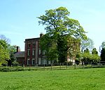 More images |
| Weston Hall | Weston-on-Trent | Country House | Early 17th century | 2 September 1952 | SK4032628350 52°51′04″N 1°24′09″W / 52.851146°N 1.402625°W / 52.851146; -1.402625 (Weston Hall) | 1088352 |  More images |
| Four bottle kilns at Greens Pottery | Church Gresley | Bottle kiln | 18th century | 29 October 1974 | SK3055818744 52°45′56″N 1°32′55″W / 52.765437°N 1.548563°W / 52.765437; -1.548563 (Four bottle kilns at Greens Pottery) | 1280950 |  More images |
| Parish Church of St Mary and Saint George | Church Gresley | Church | 15th century | 14 October 1981 | SK2932718108 52°45′35″N 1°34′01″W / 52.759787°N 1.566863°W / 52.759787; -1.566863 (Parish Church of St Mary and Saint George) | 1204963 |  More images |
See also
- Grade I listed buildings in Derbyshire
- Grade II* listed buildings in Amber Valley
- Grade II* listed buildings in Bolsover (district)
- Grade II* listed buildings in Chesterfield
- Grade II* listed buildings in Derby
- Grade II* listed buildings in Derbyshire Dales
- Grade II* listed buildings in Erewash
- Grade II* listed buildings in High Peak
- Grade II* listed buildings in North East Derbyshire
Notes
- ^ The date given is the date used by Historic England as significant for the initial building or that of an important part in the structure's description.
- ^ Sometimes known as OSGB36, the grid reference is based on the British national grid reference system used by the Ordnance Survey.
- ^ The "List Entry Number" is a unique number assigned to each listed building and scheduled monument by Historic England.
External links
- v
- t
- e
- Bedfordshire
- Berkshire
- Bristol
- Buckinghamshire
- Cambridgeshire
- Cheshire
- Cornwall
- Cumbria
- Derbyshire
- Devon
- Dorset
- Durham
- East Sussex
- East Riding of Yorkshire
- Essex
- Gloucestershire
- Greater London
- Greater Manchester
- Hampshire
- Herefordshire
- Hertfordshire
- Isle of Wight
- Kent
- Lancashire
- Leicestershire
- Lincolnshire
- Merseyside
- Norfolk
- North Yorkshire
- Northamptonshire
- Northumberland
- Nottinghamshire
- Oxfordshire
- Rutland
- Shropshire
- Somerset
- South Yorkshire
- Staffordshire
- Suffolk
- Surrey
- Tyne and Wear
- Warwickshire
- West Midlands
- West Sussex
- West Yorkshire
- Wiltshire
- Worcestershire
- Allerdale
- Amber Valley
- Ashford
- Babergh
- Barrow-in-Furness
- Basildon
- Basingstoke and Deane
- Bath and North East Somerset
- Bolsover
- Boston
- Bournemouth
- Bradford
- Braintree
- Breckland
- Brentwood
- Brighton and Hove
- Bristol
- Broadland
- Calderdale
- Cambridge
- Camden
- Canterbury
- Carlisle
- Castle Point
- Chelmsford
- Cheltenham
- Cherwell
- Cheshire East
- Cheshire West and Chester
- Chesterfield
- Chiltern
- Christchurch
- Colchester
- Copeland
- Corby
- Cotswold
- Dartford
- Daventry
- Dover
- East Cambridgeshire
- Exeter
- Mendip
- North Somerset
- North Yorkshire (district)
- Poole
- Sedgemoor
- South Somerset
- Stoke-on-Trent
- Taunton Deane
- West Somerset
- York


