Harrisville, New Jersey
Populated place in Burlington County, New Jersey, US
Unincorporated community in New Jersey, United States
39°39′41″N 74°31′19″W / 39.66139°N 74.52194°W / 39.66139; -74.52194 United States
 New Jersey
Harrisville (also called Harrisia or McCartyville[1]) is an unincorporated community and ghost town located about 6 miles (9.7 km) northwest of New Gretna within Bass River Township in Burlington County, in the U.S. state of New Jersey, in the New Jersey Pine Barrens.[2][3]
The first industry at the site of Harrisville appears to have been a sawmill built by Evi Belangee no later than 1760. Near the mouth of the Oswego River, where its floodplain narrowed, he built a dam with 5 or 6 feet of head to run his mill.[4]: 1918 The dam was enlarged in 1795, when a slitting mill, for cutting iron sheet into strips for nailmaking, was built at the site by Isaac Potts.[4]: 1918 [5]: 71 Potts had recently built Martha Furnace upstream, and when he sold the latter in 1796, he noted that its pig iron would have a natural market at the slitting mill.[5]: 85 This business was not very successful, and about 1815 it was converted to a paper plant,[1] powered by water brought by a canal from a dam on the Oswego,[5] a tributary of the Wading River. The town which was built around the factory was originally called McCartyville after the factory owner; when the Harris family bought the factory in 1855, the name was changed to Harrisville. Under the Harris family, Harrisville was a company town, with a grist mill, post office, company store, and free tenant homes for the workers of the paper mill. In 1914, a fire started in Harrisville and destroyed the entire town, leaving only ruins. Only the decayed ruins of this town exist today.[1]
-
 Remains of Harrisville, early 1970s
 -
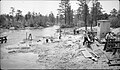 June 1939 WPA construction project on the Oswego River at the CR 679 overpass near Harrisville, just southwest of Harrisville Lake and Harrisville Dam
 -
 View of the August 20, 1939, Oswego River flood at Harrisville, as seen from where Chatsworth Road/County Route 679 crosses the river. The 1939 flood occurred despite the Harrisville Dam being in place since 1932.


References
- ^ a b c d e Beck, Henry Charlton (1961) [first published 1936 by E. P. Dutton]. Forgotten Towns of Southern New Jersey (2 ed.). Rutgers University Press. Chapter 23.
- ^ a b c U.S. Geological Survey Geographic Names Information System: Harrisville
- ^ Locality Search, State of New Jersey. Accessed December 28, 2014.
- ^ a b Braddock-Rogers, K. (1931). "Fragments of early industries in South Jersey". Journal of Chemical Education. 8 (10): 1914–1823. doi:10.1021/ed008p1914.
- ^ a b c Pierce, Arthur D. (1957). Iron in the pines: The story of New Jersey's ghost towns and bog iron. Rutgers University Press. p. 67–83. ISBN 9780813505145.
Further reading
- Dellomo, Angelo. Harrisville. Angelo Publishing Company, 1977
- v
- t
- e
Municipalities and communities of Burlington County, New Jersey, United States
County seat: Mount Holly

- Bass River
- Bordentown
- Burlington
- Chesterfield
- Cinnaminson
- Delanco
- Delran
- Eastampton
- Edgewater Park
- Evesham
- Florence
- Hainesport
- Lumberton
- Mansfield
- Maple Shade
- Medford
- Moorestown
- Mount Holly
- Mount Laurel
- New Hanover
- North Hanover
- Pemberton
- Riverside
- Shamong
- Southampton
- Springfield
- Tabernacle
- Washington
- Westampton
- Willingboro
- Woodland
unincorporated
communities
- Arneys Mount
- Arneytown
- Atsion
- Batsto
- Beaverville
- Birmingham
- Bridgeboro
- Browns Mills Junction
- Buddtown
- Bullock
- Burrs Mill
- Chairville
- Chambers Corner
- Chatsworth
- Chesterfield
- Christopher Mills
- Clermont
- Columbus
- Comical Corner
- Cropwell
- Crossroads
- Davisville
- Eayrestown
- Ewansville
- Fellowship
- Fostertown
- Georgetown
- Green Bank
- Hartford
- Hedding
- Indian Mills
- Jacksonville
- Jacobstown
- Kinkora
- Masonville
- Mount Pleasant
- New Albany
- New Lisbon
- Rancocas
- Rancocas Woods
- Red Lion
- Retreat
- Sooy Place
- Timbuctoo
- Harrisville
- High Crossing
- Ong's Hat
- New Jersey portal
- United States portal
Authority control databases | |
|---|---|
| International |
|
| National |
|


