Hils
Hill range in Germany
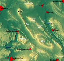
The Hils is a range of hills in Germany's Central Uplands that is up to 480.4 m high.[1] It is located in the districts of Holzminden, Hildesheim and Northeim, in the state of Lower Saxony.
Geography
The heavily forested massif of the Hils, which is part of the Leine Uplands and Weser-Leine Uplands, is immediately southeast of the knife edge ridge known as the Ith. It is located roughly northwest of Einbeck between Holzen to the west and Delligsen to the east.
The highest elevation in the Hils is the 480.4 m high Bloße Zelle, the second highest the nearby Großer Sohl (472 m), on which a monument to the poet, Wilhelm Raabe, has been erected next to the Wilhelm Raabe Tower named after him.
Numerous walking trails run through the Hils, which is accessible from the B 3, B 64 and B 240 federal highways.
Towns and villages in and around the Hils
The towns and villages which lie immediately in and around the Hils are:
Coppengrave, Delligsen, Duingen, Eschershausen, Fölziehausen, Grünenplan, Hohenbüchen, Hohe Warte, Holzen, Kaierde, Varrigsen.
References
- ^ Lower Saxony Geodata Viewer (Geodatenviewer Niedersachsen)
- v
- t
- e
Central Uplands of Germany
- Anterior Bavarian Forest Einödriegel
- Black Forest Feldberg
- Bohemian Forest Großer Arber (Bavarian Forest Großer Arber)
- Deister Bröhn
- Ebbe Mountains Nordhelle
- Egge Mountains (Prussian) Velmerstot
- Eifel Hohe Acht (Volcanic Eifel Ernstberg)
- Elbe Sandstone Mountains Großer Zschirnstein
- Elm Eilumer Horn
- Elster Mountains Kapellenberg
- Fichtel Mountains Schneeberg (Steinwald Platte, Kohlwald Sieben-Linden-Berg)
- Franconian Forest Döbraberg
- Franconian Jura Dürrenberg
- Gladenbach Uplands Angelburg
- Goshawk Forest Hohes Gras
- Harz Brocken (Blocksberg)
- Hildesheim Forest Griesberg
- Hils Bloße Zelle
- Hoher Meißner Kasseler Kuppe
- Hunsrück Erbeskopf (Soonwald Ellerspring)
- Ith Lauensteiner Kopf
- Kaiserstuhl Totenkopf
- Kaufungen Forest Hirschberg
- Kellerwald Wüstegarten
- Knüll Eisenberg
- Kyffhäuser Kulpenberg
- Lenne Mountains Homert
- Lippe Uplands Köterberg
- North Palatine Uplands Donnersberg
- Odenwald Katzenbuckel
- Ore Mountains Fichtelberg
- Palatine Forest Kalmit
- Rhön Wasserkuppe
- Rothaar Mountains Langenberg
- Saalhausen Hills Himberg
- Siebengebirge Großer Ölberg
- Solling Große Blöße
- Spessart Geiersberg (Breitsol)
- Sudetes Lausche (Luž) (Lusatian Mountains Lausche (Luž) (Zittau Mountains Lausche (Luž)))
- Süntel Hohe Egge
- Swabian Jura Lemberg (Randen Hoher Randen)
- Taunus Großer Feldberg
- Teutoburg Forest (Osning) Barnacken
- Thuringian Forest Großer Beerberg
- Thuringian Slate Mountains Großer Farmdenkopf
- Upper Palatine Forest Kreuzfelsen
- Vogelsberg Taufstein
- Weser Hills Paschenburg Mountain
- Westerwald Fuchskaute
- Wiehen Hills Heidbrink

| Authority control databases |
|
|---|
51°56′N 9°45′E / 51.933°N 9.750°E / 51.933; 9.750
 | This Lower Saxony location article is a stub. You can help Wikipedia by expanding it. |
- v
- t
- e


