Kingittorsuaq Island
Island of Greenland
72°57′55″N 56°12′45″W / 72.96528°N 56.21250°W / 72.96528; -56.21250Greenland
Kingittorsuaq Island (old spelling: Kingigtorssuaq) is a small, uninhabited island in the Avannaata municipality in northwestern Greenland. It is a small island in the southern part of the Upernavik Archipelago, located on the southwestern shores of Upernavik Icefjord, near the mouth of the latter where it opens into Baffin Bay.[1] The name of the island means "a large protruding rock" in the Greenlandic language.
History
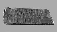
The Kingittorsuaq runestone (old spelling: Kingigtorssuaq runestone) dating from the Middle Ages[2] was found in 1824 on the highest point of the island, in a group of three cairns forming an equilateral triangle. The stone is now located at the National Museum of Denmark in Copenhagen.
References
- v
- t
- e
- Alison
- Baffin
- Inussulik
- Melville
- Qeqertaussap Iterlaa
- Sugar Loaf
- Tasiusaq
- Eqalugaarsuit
- Kangerluarsuk
- Kangerlussuaq (Kangeq Peninsula)
- Kangerlussuaq Icefjord
- Nasaussap Saqqaa
- Nuussuup Kangia
- Saqqarsuaq
- Sullua
- Upernavik Icefjord
- Alanngorsuup Sermia
- Cornell
- Giesecke
- Hayes
- Illullip Sermia
- Kjer
- Nunatakassaup Sermia
- Nunatakassaup Sermia (Tasiusaq Bay)
- Upernavik
| Melville Bay | |
|---|---|
| Inussulik Bay | |
| Sugar Loaf Bay |
|
| Tasiusaq Bay |
|
| Baffin Bay |
|
- Akullikassaq
- Anoritooq
- Devil's Thumb
- Inalugartuut
- Inngik
- Iviannernat
- Kangerluarsuup Qaqqarsua
- Kingittoq
- Kissavaussaq
- Kunngutip Qaqqaa
- Naajannguaq
- Naalungiussaq
- Najaarsuit Qaqqat
- Niaqornarsuaq
- Nunatakassak
- Nunatarsuaq
- Nunatarsuaq (Tasiusaq Bay)
- Nuniaat Qaqqarsua
- Orsugissap Qaqqarsua
- Paatuup Qaqqaa
- Qaqqasunnarsuaq
- Qassersuit
- Saattup Akia
- Sandersons Hope
- Toornaarsuttoq
- Tunullersuaq
- Tuttulikassak
- Umiasussuk
- Wandel Land


