Kings Tableland
Plateau in New South Wales, Australia

Kings Tableland
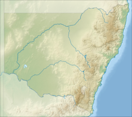
The Kings Tableland is a plateau located in the Blue Mountains in Wollondilly Shire, New South Wales, Australia.
Geography
The ridge is an eroded remnant of a sandstone layer that is approximately 1,000 metres (3,300 ft) AMSL, situated immediately south of Wentworth Falls. The Tableland is the major southerly spur of the main spine of the Blue Mountains Range and forms the beginning of the Southern Escarpment, an unbroken series of tall sandstone cliffs which fringes the Jamison, Megalong, Kanimbla, and Hartley Valleys.[2]
Situated to the west of the Blue Labyrinth area, Kings Tableland extends from Bodington Hill south to McMahons Lookout, with views over Lake Burragorang, and further about 4.8 kilometres (3.0 mi). The plateau was named by Governor Macquarie after King George III.[1]
It extends southwards from Wentworth Falls and is the eastern boundary of the Jamison Valley. There are also views from several points along the ridge, accessed via paths breaking off the main fire trail. The ridgetop fire trail itself is accessible to 4WD and AWD vehicles in good weather conditions, and is used as a mountain biking (MTB) route.
Along the way is Battleship Tops,[3] an aboriginal meeting place where ochre paintings could be seen, though these have been damaged by vandalism. A 2007 survey of the area found four rock shelters with paintings and several other sites.[4]
Indigenous significance
A portion of the Kings Tablelands has been gazetted as a camping and meeting place of significance for the Aboriginal Gandangara people. The conserved area includes a sandstone rock platform with extensive grinding and other grooves, a shelter with rock art that has been recorded as being the oldest Aboriginal site in the Blue Mountains region and containing unique vertically engraved depictions of kangaroo and bird tracks.[5][6]
Modern developments
A road from Wentworth Falls runs north and south along the plateau to the current lookout area of McMahons Point. Before the construction of Warragamba Dam the track continued down the escarpment along a track all the way to the Cox's River area in the Burragorang Valley.[7] There is a track descending from the western edge down into the Jamison Valley, originally leading to the old (now abandoned) sewerage works below the cliffs at Katoomba. The abandoned Queen Victoria Hospital is also located on Kings Tableland.
Gallery
-
 Aerial View Queen Victoria Sanitorium Kings Tableland, 2017
 -
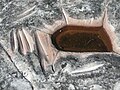 Grinding grooves, Aboriginal site, 2009.
 -
 Allocasuarina nana, commonly known as the Dwarf She-Oak, found on Kings Tablelands, 2011.


See also
 New South Wales portal
 Mountains portal


References
- ^ a b "Kings Tableland". Geographical Names Register (GNR) of NSW. Geographical Names Board of New South Wales. Retrieved 1 July 2013.

- ^ "Report on Kings Tableland, Wentworth Falls". City Planning Branch. City of Blue Mountains. November 2006. p. 3. Archived from the original on 23 June 2014. Retrieved 1 July 2013.
- ^ "Photo of Battleship Tops". Panoramio. 5 April 2010. Archived from the original on 16 May 2017. Retrieved 14 February 2012.
- ^ "August 2007 Update from the World Heritage Unit" (PDF). Archived (PDF) from the original on 4 March 2016. Retrieved 14 February 2012.
- ^ "Atlas of Aboriginal Places: Kings Tableland". Office of Environment & Heritage. Government of New South Wales. 21 May 2013. Archived from the original on 26 December 2013. Retrieved 1 July 2013.
- ^ "The Greater Blue Mountains Area: World Heritage Nomination" (PDF). prepared by the NSW National Parks & Wildlife Service in association with Environment Australia. Commonwealth of Australia. 1998. p. 49. Archived (PDF) from the original on 5 October 2013. Retrieved 1 July 2013.
- ^ "Heritage listing of Old Road". Archived from the original on 15 March 2016. Retrieved 15 March 2016.
Bibliography
- Smith, Jim (2009). "New insights into Gundungurra place naming". In Koch, Harold (ed.). Aboriginal Placenames: Naming and Re-Naming the Australian Landscape (PDF). Canberra: Australian National University. pp. 87–114. ISBN 9781921666087.
External links
- Blue Mountains, NSW, Australia Aerial video of the Jamison Valley and Kings Tableland.
- v
- t
- e
Blue Mountains topics
and localities
- Bell
- Berambing
- Bilpin
- Blaxland
- Blackheath
- Bullaburra
- Clarence
- Faulconbridge
- Glenbrook
- Hartley Vale
- Hazelbrook
- Katoomba
- Kings Tableland
- Lapstone
- Lawson
- Leura
- Linden
- Little Hartley
- Medlow Bath
- Megalong
- Mount Irvine
- Mount Riverview
- Mount Tomah
- Mount Victoria
- Mount Wilson
- North Katoomba
- Shipley
- Springwood
- Sun Valley
- Valley Heights
- Warrimoo
- Wentworth Falls
- Winmalee
- Woodford
- Yellow Rock
- Yosemite
- Banks
- Bindo
- Boyce
- Hay
- Irvine
- Narrow Neck Plateau
- Kings Tableland
- Piddington
- Solitary
- Trickett
- Wilson
- York
- Govetts Leap
- Kanangra
- Katoomba Falls
- Wentworth
- 1813 crossing of the Blue Mountains
- Clarence Tunnel
- Glenbrook rail deviations
- 1892
- 1913
- Glenbrook tunnels
- 1892
- 1913
- Lapstone Zig Zag
- Lennox Bridge, Glenbrook
- Lithgow Zig Zag
- Bargo
- Bedford
- Capertee
- Colo
- Coxs
- Du Faur
- Erskine
- Grose
- Hollanders
- Jenolan
- Jooriland
- Kedumba
- Kowmung
- Little (Oberon)
- Little (Wollondilly)
- Macdonald
- Nattai
- Nepean
- Tonalli
- Wingecarribee
- Wolgan
- Wollangambe
- Wollondilly
- Blaxland High
- Blue Mountains Grammar
- Springwood High
- Winmalee High
- Warrimoo Public
- 1999 Glenbrook rail accident
- 2001 Black Christmas / Warragamba bushfires
- 2013 New South Wales Bushfires


