Ladder of Tyre
Geographical feature of Lebanon and the Phoenician Coast


Ladder of Tyre
Ladder of Tyre (Aramaic: Sûlama de Ṣôr), (Greek: Ἡ κλίμαξ Τύρου), also known as the Ladder of the Tyrians and the Promontory of Tyre, is a geographical feature mentioned in Greek and Hebrew sources, distinguished by a littoral mountainous range, the highest point of which is distant 18.5 kilometres (11.5 mi) north of Acre in northern Israel. The range stretches beyond Tyre in southern Lebanon. Along its Mediterranean coastline, the Ladder of Tyre skirts an area of about five miles wide at its greatest width, and is distinguished by capes that jut westward into the sea from the ridge which runs parallel to the general line of the coast. These capes project more than a mile into the sea, and rise precipitously at a mean elevation of 250 feet (76 m) above sea level. The Ladder of Tyre is mentioned in the Babylonian Talmud,[1] in the Jerusalem Talmud,[2] in the First Book of Maccabees (11:59), and in the writings of Josephus.[3]

According to the Babylonian Talmud, the waters of the region were formerly known for the marine mollusk (Murex), harvested for its blue-dye.[4][5] The 1st-century historian Josephus puts 100 stadia (c. 11½ mi.; 18½ km.) from the north of Acre to the highest point (massif) in the promontory known as the Ladder of Tyre.[6] This high place is now associated with Rosh HaNikra grottoes (Scala Tyriorum), and which marked the southern pass into Phoenicia proper, and formed the boundary between that country and the kingdom of Israel. [7][8][9] According to Josephus, a place nearby was also known for its fine, crystalline sand used in glass making.
Adolf Neubauer and Henry Baker Tristram thought that the Ladder of Tyre was to be identified with Cape Blanco (Ras el-Abyad), about 9.6 kilometres (6.0 mi) north of Rās en-Nakūrah and belonging to the same mountain range.[10][11] According to historical geographer Joseph Schwarz, where the Mount Amana range terminates at the rock cliffs of Rās en-Nakūrah, "on this rock is a narrow ascent, shaped somewhat like steps, by which its summit can be reached; hence it is called in the Talmud the Ladder of Tyre."[12] Claude Reignier Conder was of the same opinion, that the promontory of Nakūrah was the same as the ancient Ladder of Tyre.[13] Historical geographer, Isaac Goldhor, places the Ladder of Tyre at a distance of 3 biblical miles from Achziv.[14]
Gallery
-
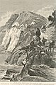
 1836
1836 -
 1839
1839 -
 1881
1881 -
 1900
1900 -
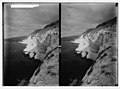
 1900
1900 -
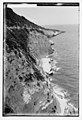
 1918
1918 -
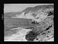
 1918
1918 -
 1920
1920


References
- ^ Shabbat 26a; Betza 25b
- ^ Baba Kama, ch. IV; Abod. Zar. 1:9
- ^ Rodgers, Zuleika; et al. (2009), p. 194
- ^ Babylonian Talmud (Shabbat 26a), which reads: "Said R. Jose: [What is meant by], 'And Nebuzaradan the captain of the guard left certain of the poor of the land for kormim and for yogvim?' (Jeremiah 52:16). Kormim, these are they who harvest the balsam from Ein Gedi to Ramatha; Yogvim, these are they that harvest the marine mollusk from the Ladder of Tyre to Haifa."
- ^ Jensen (1963), p. 106; Cf. Safrai, et al. (1976), p. 676
- ^ Josephus, De Bello Judaico (The Jewish War) 2.10.2
- ^ Kitto (1865), p. 769
- ^ Conder, C.R. (1881), pp. 191–192
- ^ Guérin, V. (1880), pp. 167–168
- ^ Neubauer, A. (1868), p. 39
- ^ Tristram, H.B. (1865), p. 61
- ^ Schwarz, Joseph (1969), p. 55
- ^ Conder (1878), p. 270
- ^ Goldhor (1913), p. 86
Bibliography
- Conder, C.R. (1878). Tent Work in Palestine. A Record of Discovery and Adventure. Vol. 1. London: Richard Bentley & Son (published for the Committee of the PEF). OCLC 23589738.
- Conder, C.R.; Kitchener, H.H. (1881). The Survey of Western Palestine: Memoirs of the Topography, Orography, Hydrography, and Archaeology. Vol. 1. London: Committee of the Palestine Exploration Fund.
- Goldhor, Isaac [in Hebrew] (1913). Adamat Kodesh, being the Land of Israel (in Hebrew). Vol. 2. Jerusalem: Yiddish Literature. OCLC 233044063.
- Guérin, V. (1880). Description Géographique Historique et Archéologique de la Palestine (in French). Vol. 3: Galilee, pt. 2. Paris: L'Imprimerie Nationale.
- Jensen, Lloyd B. (1963). "Royal Purple of Tyre". Journal of Near Eastern Studies. 22 (2). Chicago: The University of Chicago Press: 104–118. doi:10.1086/371717. JSTOR 543305. S2CID 161424526.
- Josephus. De Bello Judaico (Wars of the Jews). Perseus Books Group.
- Kitto, J. (1865). A Cyclopedia of Biblical Literature. Vol. 2 (3rd edition). Philadelphia: J.B. Lippincott and Co.
- Neubauer, A. (1868). La géographie du Talmud : mémoire couronné par l'Académie des inscriptions et belles-lettres (in French). Paris: Lévy. OCLC 474727878.
- Rodgers, Zuleika; Daly-Denton, Margaret; Fitzpatrick-McKinley, Anne, eds. (2009). A Wandering Galilean: Essays in Honour of Seán Freyne. Leiden: Brill. ISBN 9789004173552. OCLC 297406369.
- Safrai, S.; Flusser, D. (1976). The Jewish People in the First Century (Historical Geography, Political History). Vol. 2. Amsterdam: Van Gorcum, Assen.ISBN 90-232-1436-6
- Schwarz, Joseph [in Hebrew] (1969). A Descriptive Geography and Brief Historical Sketch of Palestine. Translated by Isaac Leeser. New York: Hermon Press. OCLC 255586852. (reprinted A. Hart: Philadelphia 1850)
- Tristram, H.B. (1865). Land of Israel, A Journal of travel in Palestine, undertaken with special reference to its physical character. London: Society for Promoting Christian Knowledge.
External links
- Ladder of Tyre, Library of Congress
- Survey of Western Palestine, Map 3: IAA, Wikimedia commons
- v
- t
- e

Capital: Tyre
- Aabbassiyeh
- Aalma ech Chaab
- Ain Baal
- Aitit
- Barish
- Bayyad
- Bazourieh
- Bedias
- Boustane
- Borj Ech Chemali
- Borj Rahal
- Chamaa
- Chaitiyeh
- Chehabiyeh
- Chehour
- Chihine
- Debaal
- Deir Aames
- Deir Kifa
- Deir Qanoun En Nahr
- Halloussiyeh
- Hanaouay
- Jennata
- Jibbain
- Jwaya
- Kneisseh
- Maarakeh
- Maaroub
- Mansouri
- Majadel
- Majdel Zoun
- Mahrouna
- Marwahin
- Naqoura
- Qana
- Qlaileh
- Ras al-Ain
- Rechknanay
- Selaa
- Siddikine
- Srifa
- Tayr Debba
- Tayr Falsay
- Tayr Harfa
- Toura
- Yarine
- Zalloutieh
- Zibqin


