List of National Natural Landmarks in Missouri
Map all coordinates using OpenStreetMap
Download coordinates as:
- KML
- GPX (all coordinates)
- GPX (primary coordinates)
- GPX (secondary coordinates)
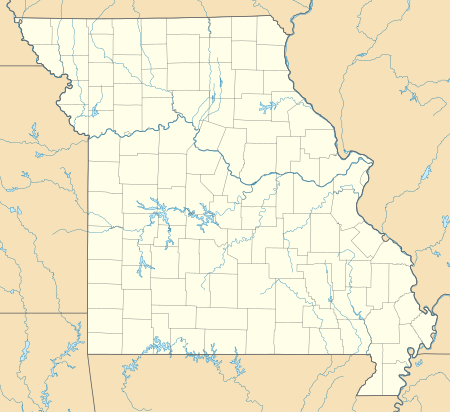
From List of National Natural Landmarks, these are the National Natural Landmarks in Missouri. There are 16 in total.

Golden Prairie
Grand Gulf State Park
Greer Spring
Maramec Spring
Mark Twain Cave
Marvel Cave
class=notpageimage|
Missouri National Natural Landmarks (clickable map)| Name | Image | Date | Location | County | Ownership | Description | |
|---|---|---|---|---|---|---|---|
| 1 | Big Oak Tree State Park | 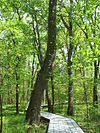 | May 1986 | East Prairie 36°39′18″N 89°19′42″W / 36.655°N 89.32833°W / 36.655; -89.32833 (Big Oak Tree State Park) | Mississippi | state | A rare untouched wet-mesic bottomland hardwood forest in the Mississippi Alluvial Plain, it is the home of several state and national champion trees |
| 2 | Carroll Cave | 1977 | Camden | private | Contains a dendritic system of subsurface karst streams and tributaries. | ||
| 3 | Cupola Pond | 1974 | Ripley | federal | One of the most ancient sinkhole ponds in the Ozark plateaus. Located in Mark Twain National Forest. | ||
| 4 | Golden Prairie |  | 1975 | Golden City 37°21′45″N 94°09′01″W / 37.36261°N 94.15019°W / 37.36261; -94.15019 (Golden Prairie) | Barton | private | An unplowed remnant of the tall grass prairie ecosystem. |
| 5 | Grand Gulf State Park |  | June 1971 | Thayer 36°31′27″N 91°32′38″W / 36.52427°N 91.54389°W / 36.52427; -91.54389 (Grand Gulf State Park) | Oregon | state | An excellent example of karst topography, this canyon is a collapsed dolomite cave with a 200 feet (61 m) natural bridge. Water in this canyon emerges 9 miles (14 km) away in Mammoth Spring, Arkansas. |
| 6 | Greer Spring |  | 1980 | 36°47′12″N 91°20′51″W / 36.786667°N 91.3475°W / 36.786667; -91.3475 (Greer Spring) | Oregon | private | Spring in the Ozarks that discharges into a high quality, cascading stream. |
| 7 | Maple Woods Natural Area | 1980 | Clay | state | Contains a nearly virgin sugar maple and mockernut hickory forest. | ||
| 8 | Maramec Spring | 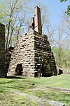 | October 1971 | St. James 37°57′19″N 91°32′11″W / 37.95526°N 91.53632°W / 37.95526; -91.53632 (Maramec Spring) | Phelps | private | A natural spring, the fifth largest in the state. It has a notable trout park and a historic iron works in a privately owned park. |
| 9 | Mark Twain and Cameron Caves |  | 1972 | 39°41′19″N 91°19′54″W / 39.68864°N 91.33153°W / 39.68864; -91.33153 (Mark Twain Cave) | Marion | private | Exceptionally good examples of the maze type of cavern development. |
| 10 | Marvel Cave | 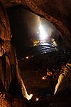 | 1972 | 36°40′03″N 93°20′23″W / 36.6675°N 93.3397°W / 36.6675; -93.3397 (Marvel Cave) | Stone | private | Includes one of the greatest dripstone units of all the Ozark caves. |
| 11 | Onondaga Cave State Park |  | 1980 | 38°03′39″N 91°13′38″W / 38.060833°N 91.227222°W / 38.060833; -91.227222 (Onondaga Cave State Park) | Crawford | state | Contains an unusually large and varied number of speleothems. |
| 12 | Pickle Springs | 1975 | Ste. Genevieve | state | Contains one of the finest Pleistocene relict habitats in Missouri. | ||
| 13 | Taberville Prairie Conservation Area |  | 1975 | St. Clair | state | One of the largest remaining virgin tall grass prairies. | |
| 14 | Tucker Prairie | 1975 | Callaway | private | A virgin tall grass prairie occurring within the transition zone between the oak-hickory forest and typical tall grass prairie. | ||
| 15 | Tumbling Creek Cave | 1980 | Taney | private | Contains the most diverse fauna known for any cave west of the Mississippi River. | ||
| 16 | Wegener Woods | 1975 | Warren | private | An essentially virgin oak-hickory-dominated forest in a condition of gradual change to a sugar maple-dominated forest. |
See also
- v
- t
- e
National Natural Landmarks in the United States
- Alabama
- Alaska
- Arizona
- Arkansas
- California
- Colorado
- Connecticut
- Delaware
- Florida
- Georgia
- Hawaii
- Idaho
- Illinois
- Indiana
- Iowa
- Kansas
- Kentucky
- Louisiana
- Maine
- Maryland
- Massachusetts
- Michigan
- Minnesota
- Mississippi
- Missouri
- Montana
- Nebraska
- Nevada
- New Hampshire
- New Jersey
- New Mexico
- New York
- North Carolina
- North Dakota
- Ohio
- Oklahoma
- Oregon
- Pennsylvania
- Rhode Island
- South Carolina
- South Dakota
- Tennessee
- Texas
- Utah
- Vermont
- Virginia
- Washington
- West Virginia
- Wisconsin
- Wyoming


