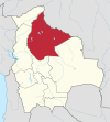
Magdalena, Beni
You can help expand this article with text translated from the corresponding article in German. (December 2010) Click [show] for important translation instructions.
- View a machine-translated version of the German article.
- Machine translation, like DeepL or Google Translate, is a useful starting point for translations, but translators must revise errors as necessary and confirm that the translation is accurate, rather than simply copy-pasting machine-translated text into the English Wikipedia.
- Do not translate text that appears unreliable or low-quality. If possible, verify the text with references provided in the foreign-language article.
- You must provide copyright attribution in the edit summary accompanying your translation by providing an interlanguage link to the source of your translation. A model attribution edit summary is
Content in this edit is translated from the existing German Wikipedia article at [[:de:Magdalena (Beni)]]; see its history for attribution. - You may also add the template
{{Translated|de|Magdalena (Beni)}}to the talk page. - For more guidance, see Wikipedia:Translation.
Town in Beni Department, Bolivia
13°15′38″S 64°03′10″W / 13.26056°S 64.05278°W / -13.26056; -64.05278 Bolivia
 Beni Department
 (2001)
Magdalena is a town on the Itonomas River in the Beni Department in northern Bolivia, capital of the Iténez Province and the Magdalena Municipality.[1]
It is served by Magdalena Airport.
History
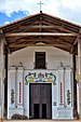
The Jesuit mission of Santa María Magdalena (or Santa Magdalena) was founded in 1720.[2] Itonama Indians resided at the mission.[3]
Climate
The yearly precipitation of the region is 1,600 mm, with a distinct dry season from May to September. Monthly average temperatures vary from 24 °C und 29 °C over the year. According to the Köppen classification system Magdalenas has a Tropical savanna climate, abbreviated "Aw".
| Climate data for Magdalenas | |||||||||||||
|---|---|---|---|---|---|---|---|---|---|---|---|---|---|
| Month | Jan | Feb | Mar | Apr | May | Jun | Jul | Aug | Sep | Oct | Nov | Dec | Year |
| Mean daily maximum °C (°F) | 33 (92) | 34 (93) | 34 (94) | 33 (92) | 31 (88) | 34 (93) | 34 (93) | 35 (95) | 36 (97) | 36 (96) | 33 (92) | 33 (91) | 34 (93) |
| Mean daily minimum °C (°F) | 22 (72) | 22 (72) | 22 (72) | 22 (72) | 18 (65) | 19 (67) | 18 (65) | 18 (64) | 20 (68) | 21 (70) | 22 (71) | 23 (73) | 21 (69) |
| Average precipitation mm (inches) | 259.2 (10.20) | 249.7 (9.83) | 225.4 (8.87) | 119.7 (4.71) | 73.2 (2.88) | 18.8 (0.74) | 14.9 (0.59) | 28.9 (1.14) | 70.4 (2.77) | 122.3 (4.81) | 189.0 (7.44) | 218.8 (8.61) | 1,590.4 (62.61) |
| Source: Senamhi [4] | |||||||||||||
References
- ^ Municipalities of Bolivia at www.editorialox.com
- ^ Block, David (1994). Mission culture on the upper Amazon: native tradition, Jesuit enterprise, and secular policy in Moxos, 1660-1880. Lincoln: University of Nebraska Press. ISBN 0-8032-1232-1..
- ^ Meireles, Denise Maldi. 1989. Guardiães da fronteira: Rio Guaporé, século XVIII. Petrópolis: Vozes. ISBN 85-326-0017-4.
- ^ "SISMET". SENAMHI. 2021. Retrieved on December 19, 2021.
- www.ine.gov.bo
- v
- t
- e

Capital: La Santísima Trinidad
and seats
- Baures (Baures)
- Exaltación (Exaltación)
- Guayaramerín (Guayaramerín)
- Huacaraje (Huacaraje)
- Loreto (Loreto)
- Magdalena (Magdalena)
- Puerto Siles (Puerto Siles)
- Reyes (Reyes)
- Riberalta (Riberalta)
- Rurrenabaque (Rurrenabaque)
- San Andrés (San Andrés)
- San Borja (San Borja)
- San Ignacio (San Ignacio)
- San Javier (San Javier)
- San Joaquín (San Joaquín)
- San Ramón (San Ramón)
- Santa Ana (Santa Ana del Yacuma)
- Santa Rosa (Santa Rosa)
- Trinidad (Trinidad)
| |||
|---|---|---|---|
| Missions |
|  | |
| Peoples | |||
| Languages |
| ||
| Geography | |||
This Beni Department location article is a stub. You can help Wikipedia by expanding it. |
- v
- t
- e


