Morgenröthe-Rautenkranz
Ortsteil of Muldenhammer in Saxony, Germany

Coat of arms
Location of Morgenröthe-Rautenkranz

50°27′N 12°31′E / 50.450°N 12.517°E / 50.450; 12.517
(2006-12-31)
08262
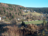
Morgenröthe-Rautenkranz is a village and a former municipality in the Vogtlandkreis district, in Saxony, Germany. Since 1 October 2009, along with Tannenbergsthal and Hammerbrücke, it is part of the municipality Muldenhammer.
Personalities
- Sigmund Jähn (1937-2019), first German cosmonaut
Gallery
-
 Morgenröthe
 -
 Vogtlandsee


References
External links
![]() Media related to Morgenröthe-Rautenkranz at Wikimedia Commons
Media related to Morgenröthe-Rautenkranz at Wikimedia Commons
- Morgenröthe-Rautenkranz in the Digital Historic Index of Places in Saxony (Digitales Historisches Ortsverzeichnis von Sachsen)
- Morgenröthe in the Digital Historic Index of Places in Saxony (Digitales Historisches Ortsverzeichnis von Sachsen)
- Rautenkranz in the Digital Historic Index of Places in Saxony (Digitales Historisches Ortsverzeichnis von Sachsen)
Authority control databases | |
|---|---|
| International |
|
| National |
|
- v
- t
- e


