National Register of Historic Places listings in eastern Worcester, Massachusetts
There are 98 properties and historic districts on the National Register of Historic Places in Worcester, Massachusetts, east of I-190 and the north-south section of I-290, which are listed below. Two listings overlap into other parts of Worcester: one of the 1767 Milestones is located in northwestern Worcester, and the Blackstone Canal Historic District traverses all three sections of the city.
Map all coordinates using OpenStreetMap
Download coordinates as:
- KML
- GPX (all coordinates)
- GPX (primary coordinates)
- GPX (secondary coordinates)
The locations of National Register properties and districts (at least for all showing latitude and longitude coordinates below) may be seen in an online map by clicking on "Map of all coordinates".[1]
This National Park Service list is complete through NPS recent listings posted May 10, 2024.[2]
Current listings
| [3] | Name on the Register | Image | Date listed[4] | Location | Description |
|---|---|---|---|---|---|
| 1 | 1767 Milestones |  | April 7, 1971 (#71000084) | Various locations between Springfield and Boston 42°16′41″N 71°47′40″W / 42.2781°N 71.7944°W / 42.2781; -71.7944 (1767 Milestones) | Milestone 47 is in eastern Worcester; Milestone 48 is in northwestern Worcester. |
| 2 | Arad Alexander House |  | March 5, 1980 (#80000544) | 53 Waverly St. 42°15′24″N 71°47′33″W / 42.2567°N 71.7925°W / 42.2567; -71.7925 (Arad Alexander House) | |
| 3 | Ludwig Anderson Three-Decker |  | February 9, 1990 (#89002355) | 4 Fairbanks St. 42°14′41″N 71°47′42″W / 42.2447°N 71.795°W / 42.2447; -71.795 (Ludwig Anderson Three-Decker) | |
| 4 | Peter Baker Three-Decker |  | February 9, 1990 (#89002445) | 90 Vernon St. 42°14′54″N 71°47′42″W / 42.2483°N 71.7951°W / 42.2483; -71.7951 (Peter Baker Three-Decker) | |
| 5 | Richard Barker Octagon House |  | March 5, 1980 (#80000592) | 312 Plantation St. 42°16′11″N 71°46′16″W / 42.2697°N 71.7711°W / 42.2697; -71.7711 (Richard Barker Octagon House) | |
| 6 | George Bentley House |  | March 5, 1980 (#80000560) | 9 Earle St. 42°16′16″N 71°47′29″W / 42.2711°N 71.7914°W / 42.2711; -71.7914 (George Bentley House) | |
| 7 | Blackstone Canal Historic District |  | August 15, 1995 (#95001004) | Sites along the historic route of the Blackstone Canal 42°13′24″N 71°47′15″W / 42.2234°N 71.7876°W / 42.2234; -71.7876 (Blackstone Canal Historic District) | Listing extends into other parts of Worcester, as well as Sutton, Grafton, Millbury, Northbridge, Uxbridge, Millville, Blackstone; the Rhode Island section of the canal is the subject of a separate listing (#91001536). |
| 8 | Lydia Blodgett Three-Decker |  | February 9, 1990 (#89002417) | 167 Eastern Ave. 42°16′29″N 71°47′18″W / 42.2747°N 71.7883°W / 42.2747; -71.7883 (Lydia Blodgett Three-Decker) | |
| 9 | Bloomingdale Firehouse | 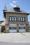 | March 5, 1980 (#80000593) | 676 Franklin St. 42°16′02″N 71°46′27″W / 42.2672°N 71.7742°W / 42.2672; -71.7742 (Bloomingdale Firehouse) | |
| 10 | Bloomingdale School | 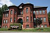 | March 5, 1980 (#80000562) | 327 Plantation St. 42°16′15″N 71°46′15″W / 42.2708°N 71.7709°W / 42.2708; -71.7709 (Bloomingdale School) | |
| 11 | Borden-Pond House | 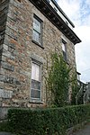 | March 5, 1980 (#80000590) | 40 Laurel St. 42°16′08″N 71°47′34″W / 42.2689°N 71.7928°W / 42.2689; -71.7928 (Borden-Pond House) | |
| 12 | Eric Bostrom Three-Decker | 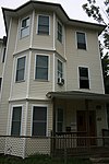 | February 9, 1990 (#89002414) | 152 Eastern Ave. 42°16′26″N 71°47′21″W / 42.2739°N 71.7892°W / 42.2739; -71.7892 (Eric Bostrom Three-Decker) | |
| 13 | Boulevard Diner | 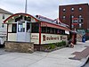 | November 22, 2000 (#00001394) | 155 Shrewsbury St. 42°15′53″N 71°47′14″W / 42.2647°N 71.7872°W / 42.2647; -71.7872 (Boulevard Diner) | |
| 14 | Henry Bousquet Three-Decker |  | February 9, 1990 (#89002360) | 8-10 Fairmont Ave. 42°15′39″N 71°46′48″W / 42.2607°N 71.7801°W / 42.2607; -71.7801 (Henry Bousquet Three-Decker) | |
| 15 | Eric Carlson Three-Decker |  | February 9, 1990 (#89002415) | 154 Eastern Ave. 42°16′27″N 71°47′20″W / 42.2742°N 71.7889°W / 42.2742; -71.7889 (Eric Carlson Three-Decker) | |
| 16 | Chadwick-Brittan House |  | March 5, 1980 (#80000518) | 309 Lincoln St. 42°17′11″N 71°47′25″W / 42.2864°N 71.7903°W / 42.2864; -71.7903 (Chadwick-Brittan House) | |
| 17 | Frederick Daniels House |  | March 5, 1980 (#80000526) | 148 Lincoln St. 42°16′43″N 71°47′39″W / 42.2786°N 71.7942°W / 42.2786; -71.7942 (Frederick Daniels House) | |
| 18 | Dartmouth Street School |  | March 5, 1980 (#80000546) | 13 Dartmouth St. 42°15′28″N 71°46′53″W / 42.2578°N 71.7814°W / 42.2578; -71.7814 (Dartmouth Street School) | |
| 19 | Rodney Davis Three-Decker |  | February 9, 1990 (#89002398) | 62 Catharine St. 42°16′27″N 71°47′16″W / 42.2741°N 71.7878°W / 42.2741; -71.7878 (Rodney Davis Three-Decker) | |
| 20 | Mary Dean Three-Decker |  | February 9, 1990 (#89002390) | 130 Belmont St. 42°16′19″N 71°47′29″W / 42.2719°N 71.7914°W / 42.2719; -71.7914 (Mary Dean Three-Decker) | Demolished. |
| 21 | Louis Delsignore Three-Decker |  | February 9, 1990 (#89002396) | 12 Imperial Rd. 42°16′18″N 71°46′37″W / 42.2716°N 71.7769°W / 42.2716; -71.7769 (Louis Delsignore Three-Decker) | |
| 22 | Philip Duke Three-Decker |  | February 9, 1990 (#89002425) | 7 Maxwell St. 42°14′25″N 71°47′59″W / 42.2403°N 71.7997°W / 42.2403; -71.7997 (Philip Duke Three-Decker) | |
| 23 | David Dworman Three-Decker |  | February 9, 1990 (#89002430) | 159 Providence St. 42°14′41″N 71°47′30″W / 42.2447°N 71.7917°W / 42.2447; -71.7917 (David Dworman Three-Decker) | |
| 24 | East Worcester School-Norcross Factory |  | March 5, 1980 (#80000618) | 10 E. Worcester St. 42°15′45″N 71°47′26″W / 42.2625°N 71.7906°W / 42.2625; -71.7906 (East Worcester School-Norcross Factory) | |
| 25 | Elizabeth Street School | 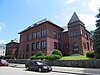 | March 5, 1980 (#80000589) | 31 Elizabeth St. 42°16′12″N 71°47′29″W / 42.27°N 71.7914°W / 42.27; -71.7914 (Elizabeth Street School) | |
| 26 | Knut Erikson Three-Decker | 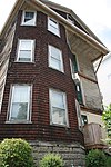 | February 9, 1990 (#89002438) | 19 Stanton St. 42°16′24″N 71°47′09″W / 42.2733°N 71.7858°W / 42.2733; -71.7858 (Knut Erikson Three-Decker) | |
| 27 | Euclid Avenue-Montrose Street Historic District |  | February 9, 1990 (#89002357) | Along Euclid Ave. and Montrose St., between Vernon St. and Perry Ave. 42°14′46″N 71°47′52″W / 42.2461°N 71.7978°W / 42.2461; -71.7978 (Euclid Avenue-Montrose Street Historic District) | |
| 28 | Fay Street Historic District | 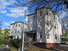 | February 9, 1990 (#89002372) | 4-6 Fay St. 42°15′25″N 71°47′16″W / 42.2569°N 71.7878°W / 42.2569; -71.7878 (Fay Street Historic District) | |
| 29 | Amos Flagg House | 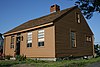 | March 5, 1980 (#80000515) | 246 Burncoat St. 42°18′11″N 71°47′24″W / 42.3031°N 71.79°W / 42.3031; -71.79 (Amos Flagg House) | |
| 30 | Benjamin Flagg House |  | March 5, 1980 (#80000620) | 136 Plantation St. 42°15′35″N 71°46′52″W / 42.2597°N 71.7811°W / 42.2597; -71.7811 (Benjamin Flagg House) | |
| 31 | George Fontaine Three-Decker |  | February 9, 1990 (#89002447) | 141 Vernon St. 42°14′40″N 71°47′47″W / 42.2444°N 71.7964°W / 42.2444; -71.7964 (George Fontaine Three-Decker) | |
| 32 | Forest Hill Cottage |  | March 5, 1980 (#80000529) | 22 Windsor St. 42°16′40″N 71°47′27″W / 42.2778°N 71.7908°W / 42.2778; -71.7908 (Forest Hill Cottage) | |
| 33 | Andrew Friberg Three-Decker |  | February 9, 1990 (#89002387) | 26 Ames St. 42°14′33″N 71°47′43″W / 42.2425°N 71.7953°W / 42.2425; -71.7953 (Andrew Friberg Three-Decker) | |
| 34 | George Gale House |  | March 5, 1980 (#80000561) | 15 Elizabeth St. 42°16′15″N 71°47′27″W / 42.2708°N 71.7908°W / 42.2708; -71.7908 (George Gale House) | |
| 35 | Thomas Giguere Three-Decker |  | February 9, 1990 (#89002356) | 18 Fairhaven Rd. 42°18′32″N 71°47′52″W / 42.3089°N 71.7978°W / 42.3089; -71.7978 (Thomas Giguere Three-Decker) | |
| 36 | Goddard House |  | March 5, 1980 (#80000555) | 12 Catharine St. 42°16′31″N 71°47′39″W / 42.2753°N 71.7942°W / 42.2753; -71.7942 (Goddard House) | House demolished.[5] Now a parking lot for an Oak Ave. business. |
| 37 | Goldberg Building |  | November 19, 2007 (#07001202) | 97-103 Water St. 42°15′23″N 71°47′46″W / 42.2563°N 71.796°W / 42.2563; -71.796 (Goldberg Building) | |
| 38 | Grafton Street School |  | March 5, 1980 (#80000545) | 311 Grafton St. 42°15′23″N 71°47′15″W / 42.2564°N 71.7875°W / 42.2564; -71.7875 (Grafton Street School) | |
| 39 | Green Hill Park Shelter |  | March 5, 1980 (#80000522) | Green Hill Parkway 42°16′54″N 71°46′58″W / 42.2817°N 71.7828°W / 42.2817; -71.7828 (Green Hill Park Shelter) | |
| 40 | Greendale Branch Library |  | March 5, 1980 (#80000511) | 470 W. Boylston St. 42°18′26″N 71°47′59″W / 42.3072°N 71.7997°W / 42.3072; -71.7997 (Greendale Branch Library) | |
| 41 | Greendale Village Improvement Society Building |  | November 7, 1976 (#76000949) | 480 W. Boylston St. 42°18′27″N 71°47′59″W / 42.3075°N 71.7997°W / 42.3075; -71.7997 (Greendale Village Improvement Society Building) | |
| 42 | Evert Gullberg Three-Decker |  | February 9, 1990 (#89002388) | 18 Ashton St. 42°16′58″N 71°47′27″W / 42.2828°N 71.7908°W / 42.2828; -71.7908 (Evert Gullberg Three-Decker) | |
| 43 | Higgins Armory Museum |  | March 5, 1980 (#80000514) | 100 Barber Ave. 42°17′50″N 71°47′57″W / 42.2972°N 71.7992°W / 42.2972; -71.7992 (Higgins Armory Museum) | |
| 44 | College of the Holy Cross |  | March 5, 1980 (#80000491) | Holy Cross College Campus 42°14′21″N 71°48′30″W / 42.2392°N 71.8083°W / 42.2392; -71.8083 (College of the Holy Cross) | This listing encompasses only Fenwick and O'Kane Halls. |
| 45 | Houghton Street Historic District |  | February 9, 1990 (#89002371) | Houghton St. between Palm and Dorchester Sts. 42°15′10″N 71°47′08″W / 42.2528°N 71.7856°W / 42.2528; -71.7856 (Houghton Street Historic District) | |
| 46 | David Hunt Three-Decker |  | February 9, 1990 (#89002412) | 26 Louise St. 42°14′28″N 71°47′46″W / 42.2411°N 71.7961°W / 42.2411; -71.7961 (David Hunt Three-Decker) | |
| 47 | Ingleside Avenue Historic District |  | February 9, 1990 (#89002369) | 218-220 and 226-228 Ingleside Ave. 42°15′05″N 71°46′48″W / 42.2515°N 71.7801°W / 42.2515; -71.7801 (Ingleside Avenue Historic District) | |
| 48 | John and Edward Johnson Three-Decker |  | February 9, 1990 (#89002416) | 31 Louise St. 42°14′29″N 71°47′46″W / 42.2415°N 71.7961°W / 42.2415; -71.7961 (John and Edward Johnson Three-Decker) | |
| 49 | John Johnson Three-Decker |  | February 9, 1990 (#89002408) | 140 Eastern St. 42°16′23″N 71°47′22″W / 42.2731°N 71.7894°W / 42.2731; -71.7894 (John Johnson Three-Decker) | |
| 50 | Paul Johnson Three-Decker |  | February 9, 1990 (#89002437) | 7 Stanton St. 42°16′23″N 71°47′10″W / 42.2731°N 71.7861°W / 42.2731; -71.7861 (Paul Johnson Three-Decker) | |
| 51 | Erick Kaller Three-Decker |  | February 9, 1990 (#89002413) | 146 Eastern Ave. 42°16′24″N 71°47′22″W / 42.2733°N 71.7894°W / 42.2733; -71.7894 (Erick Kaller Three-Decker) | |
| 52 | Erick Kaller Three-Decker |  | February 9, 1990 (#89002411) | 148 Eastern Ave. 42°16′25″N 71°47′22″W / 42.2736°N 71.7894°W / 42.2736; -71.7894 (Erick Kaller Three-Decker) | |
| 53 | Larchmont |  | March 5, 1980 (#80000492) | 36 Butler St. 42°14′06″N 71°47′58″W / 42.235°N 71.7994°W / 42.235; -71.7994 (Larchmont) | |
| 54 | Swan Larson Three-Decker |  | February 9, 1990 (#89002443) | 12 Summerhill Ave. 42°18′20″N 71°47′56″W / 42.3056°N 71.7989°W / 42.3056; -71.7989 (Swan Larson Three-Decker) | |
| 55 | Morris Levenson Three-Decker |  | February 9, 1990 (#89002446) | 38 Plantation St. 42°15′12″N 71°46′56″W / 42.2533°N 71.7822°W / 42.2533; -71.7822 (Morris Levenson Three-Decker) | |
| 56 | Charles Lundberg Three-Decker |  | February 9, 1990 (#89002399) | 67 Catharine St. 42°16′27″N 71°47′16″W / 42.2742°N 71.7878°W / 42.2742; -71.7878 (Charles Lundberg Three-Decker) | |
| 57 | Charles Magnuson Three-Decker |  | February 9, 1990 (#89002434) | 56/58 Olga Ave. 42°16′27″N 71°47′03″W / 42.2742°N 71.7842°W / 42.2742; -71.7842 (Charles Magnuson Three-Decker) | |
| 58 | Malvern Road School |  | October 4, 1984 (#84000096) | Malvern Rd. and Southbridge St. 42°14′07″N 71°49′01″W / 42.2353°N 71.8169°W / 42.2353; -71.8169 (Malvern Road School) | |
| 59 | Anthony Massad Three-Decker |  | February 9, 1990 (#89002380) | 14 Harlow St. 42°17′01″N 71°47′39″W / 42.2836°N 71.7942°W / 42.2836; -71.7942 (Anthony Massad Three-Decker) | |
| 60 | Patrick McGrath Three-Decker |  | February 9, 1990 (#89002407) | 40 Dorchester St. 42°15′05″N 71°47′40″W / 42.2514°N 71.7944°W / 42.2514; -71.7944 (Patrick McGrath Three-Decker) | |
| 61 | Patrick McGuinness Three-Decker |  | February 9, 1990 (#89002439) | 25 Suffield St. 42°14′59″N 71°47′50″W / 42.2497°N 71.7972°W / 42.2497; -71.7972 (Patrick McGuinness Three-Decker) | |
| 62 | Frank McPartland Three-Decker |  | February 9, 1990 (#89002436) | 61 Paine St. 42°16′54″N 71°47′40″W / 42.2817°N 71.7944°W / 42.2817; -71.7944 (Frank McPartland Three-Decker) | |
| 63 | Charles Miles House |  | March 5, 1980 (#80000527) | 13 Lincoln St. 42°16′41″N 71°47′39″W / 42.2781°N 71.7942°W / 42.2781; -71.7942 (Charles Miles House) | |
| 64 | Jesse Moore House |  | March 5, 1980 (#80000557) | 25 Catharine St. 42°16′32″N 71°47′32″W / 42.2756°N 71.7922°W / 42.2756; -71.7922 (Jesse Moore House) | |
| 65 | Sarah Munroe Three-Decker |  | February 9, 1990 (#89002432) | 11 Rodney St. 42°16′23″N 71°47′15″W / 42.2731°N 71.7875°W / 42.2731; -71.7875 (Sarah Munroe Three-Decker) | Also spelled "Monroe". |
| 66 | Patrick Murphy Three-Decker |  | February 9, 1990 (#89002404) | 31 Jefferson St. 42°15′13″N 71°47′38″W / 42.2536°N 71.7939°W / 42.2536; -71.7939 (Patrick Murphy Three-Decker) | |
| 67 | Christina Nelson Three-Decker |  | February 9, 1990 (#89002391) | 45 Butler St. 42°14′03″N 71°48′00″W / 42.2342°N 71.8°W / 42.2342; -71.8 (Christina Nelson Three-Decker) | |
| 68 | Richard O'Brien Three-Decker |  | February 9, 1990 (#89002441) | 43 Suffolk St. 42°15′30″N 71°47′15″W / 42.2583°N 71.7875°W / 42.2583; -71.7875 (Richard O'Brien Three-Decker) | |
| 69 | Odd Fellows' Home |  | March 5, 1980 (#80000513) | 40 Randolph Rd. 42°17′56″N 71°47′51″W / 42.2989°N 71.7975°W / 42.2989; -71.7975 (Odd Fellows' Home) | Building was torn down to make way for construction of an alzheimer's/dementia facility. |
| 70 | Timothy Paine House |  | April 30, 1976 (#76000948) | 140 Lincoln St. 42°16′41″N 71°47′42″W / 42.2781°N 71.795°W / 42.2781; -71.795 (Timothy Paine House) | |
| 71 | Perry Avenue Historic District |  | February 9, 1990 (#89002367) | 45-55 Perry Ave. 42°14′53″N 71°47′54″W / 42.2481°N 71.7983°W / 42.2481; -71.7983 (Perry Avenue Historic District) | |
| 72 | Lars Petterson-Adolph Carlson Three-Decker |  | February 9, 1990 (#89002358) | 76 Fairhaven Rd. 42°18′32″N 71°47′43″W / 42.3089°N 71.7953°W / 42.3089; -71.7953 (Lars Petterson-Adolph Carlson Three-Decker) | |
| 73 | Lars Petterson-Fred Gurney Three-Decker |  | February 9, 1990 (#89002368) | 2 Harlow St. 42°17′00″N 71°47′33″W / 42.2833°N 71.7925°W / 42.2833; -71.7925 (Lars Petterson-Fred Gurney Three-Decker) | |
| 74 | Lars Petterson-Silas Archer Three-Decker |  | February 9, 1990 (#89002359) | 80 Fairhaven Rd. 42°18′32″N 71°47′40″W / 42.3089°N 71.7944°W / 42.3089; -71.7944 (Lars Petterson-Silas Archer Three-Decker) | |
| 75 | Lars Petterson-James Reidy Three-Decker |  | February 9, 1990 (#89002376) | 4 Harlow St. 42°17′00″N 71°47′35″W / 42.2833°N 71.7931°W / 42.2833; -71.7931 (Lars Petterson-James Reidy Three-Decker) | |
| 76 | Addison Prentiss House |  | March 5, 1980 (#80000558) | 3 Channing Way 42°16′26″N 71°47′32″W / 42.274°N 71.7923°W / 42.274; -71.7923 (Addison Prentiss House) | |
| 77 | Providence Street Firehouse |  | March 5, 1980 (#80000553) | 98 Providence St. 42°15′04″N 71°47′36″W / 42.2511°N 71.7933°W / 42.2511; -71.7933 (Providence Street Firehouse) | |
| 78 | Providence Street Historic District |  | February 9, 1990 (#89002381) | 127-145 Providence St. 42°14′47″N 71°47′32″W / 42.2464°N 71.7922°W / 42.2464; -71.7922 (Providence Street Historic District) | |
| 79 | Arthur Provost Three-Decker |  | February 9, 1990 (#89002444) | 30 Thorne St. 42°15′27″N 71°47′04″W / 42.2575°N 71.7844°W / 42.2575; -71.7844 (Arthur Provost Three-Decker) | |
| 80 | Quinsigamond Branch Library |  | March 5, 1980 (#80000494) | 812 Millbury St. 42°14′03″N 71°47′47″W / 42.2342°N 71.7964°W / 42.2342; -71.7964 (Quinsigamond Branch Library) | |
| 81 | Quinsigamond Firehouse | 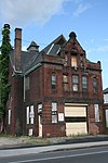 | March 5, 1980 (#80000495) | 15 Blackstone River Rd. 42°14′01″N 71°47′44″W / 42.2336°N 71.7956°W / 42.2336; -71.7956 (Quinsigamond Firehouse) | |
| 82 | Ezra Rice House |  | March 5, 1980 (#80000507) | 1133 W. Boylston St. 42°20′04″N 71°47′24″W / 42.3344°N 71.79°W / 42.3344; -71.79 (Ezra Rice House) | |
| 83 | Catharine Roynane Three-Decker | 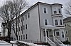 | February 9, 1990 (#89002397) | 18 Ingalls St. 42°15′15″N 71°47′44″W / 42.2541°N 71.7956°W / 42.2541; -71.7956 (Catharine Roynane Three-Decker) | Also spelled "Ronayne". |
| 84 | Draper Ruggles House |  | March 5, 1980 (#80000556) | 21 Catharine St. 42°16′32″N 71°47′35″W / 42.2756°N 71.7931°W / 42.2756; -71.7931 (Draper Ruggles House) | |
| 85 | Shaarai Torah Synagogue |  | May 7, 1990 (#90000729) | 32 Providence St. 42°15′21″N 71°47′38″W / 42.2558°N 71.7939°W / 42.2558; -71.7939 (Shaarai Torah Synagogue) | |
| 86 | Bridget Shea Three-Decker |  | February 9, 1990 (#89002400) | 21 Jefferson St. 42°15′13″N 71°47′43″W / 42.2536°N 71.7953°W / 42.2536; -71.7953 (Bridget Shea Three-Decker) | |
| 87 | Soho Cottage |  | March 5, 1980 (#80000528) | 21 Windsor St. 42°16′40″N 71°47′28″W / 42.2778°N 71.7912°W / 42.2778; -71.7912 (Soho Cottage) | |
| 88 | Edna Stoliker Three-Decker |  | February 9, 1990 (#89002449) | 41 Plantation St. 42°15′13″N 71°46′57″W / 42.2536°N 71.7825°W / 42.2536; -71.7825 (Edna Stoliker Three-Decker) | |
| 89 | Leonard Sturtevant House |  | March 5, 1980 (#80000591) | 84 Mulberry St. 42°16′02″N 71°47′32″W / 42.2671°N 71.7923°W / 42.2671; -71.7923 (Leonard Sturtevant House) | |
| 90 | D. Wheeler Swift House | 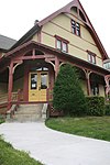 | March 5, 1980 (#80000559) | 22 Oak Ave. 42°16′23″N 71°47′37″W / 42.2731°N 71.7936°W / 42.2731; -71.7936 (D. Wheeler Swift House) | |
| 91 | Upsala Street School |  | March 5, 1980 (#80000493) | 36 Upsala St. 42°14′30″N 71°47′44″W / 42.2417°N 71.7956°W / 42.2417; -71.7956 (Upsala Street School) | |
| 92 | View Street Historic District | 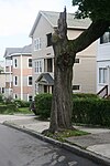 | February 9, 1990 (#89002361) | 7-17 and 8-16 View St. 42°14′49″N 71°47′50″W / 42.2469°N 71.7972°W / 42.2469; -71.7972 (View Street Historic District) | |
| 93 | Ward Street School-Millbury Street |  | March 5, 1980 (#80000488) | 389 Millbury St. 42°14′43″N 71°48′06″W / 42.2453°N 71.8017°W / 42.2453; -71.8017 (Ward Street School-Millbury Street) | |
| 94 | Woodford Street Historic District |  | February 9, 1990 (#89002365) | 34-39 and 38-40 Woodford St. 42°14′36″N 71°47′26″W / 42.2433°N 71.7906°W / 42.2433; -71.7906 (Woodford Street Historic District) | |
| 95 | Worcester Academy Historic District |  | March 5, 1980 (#80000478) | Worcester Academy Campus 42°15′10″N 71°47′30″W / 42.2528°N 71.7917°W / 42.2528; -71.7917 (Worcester Academy Historic District) | District includes Walker Hall, the Megaron, Adams Hall, Dexter Hall, Kingsley Laboratories, and Daniels Gymnasium. |
| 96 | Worcester Asylum and related buildings |  | March 5, 1980 (#80000530) | 305 Belmont St. 42°16′39″N 71°46′25″W / 42.2775°N 71.7736°W / 42.2775; -71.7736 (Worcester Asylum and related buildings) | Now known as the Worcester State Hospital. |
| 97 | Worcester State Hospital Farmhouse |  | July 3, 2017 (#100001262) | 361 Plantation St. 42°16′32″N 71°46′02″W / 42.275439°N 71.767231°W / 42.275439; -71.767231 (Worcester State Hospital Farmhouse) | |
| 98 | Anthony Zemaitis Three-Decker |  | February 9, 1990 (#89002401) | 35 Dartmouth St. 42°15′28″N 71°46′46″W / 42.2578°N 71.7794°W / 42.2578; -71.7794 (Anthony Zemaitis Three-Decker) |
See also
- National Register of Historic Places listings in Worcester, Massachusetts
- National Register of Historic Places listings in northwestern Worcester, Massachusetts
- National Register of Historic Places listings in southwestern Worcester, Massachusetts
- National Register of Historic Places listings in Worcester County, Massachusetts
References
- ^ The latitude and longitude information provided in this table was derived originally from the National Register Information System, which has been found to be fairly accurate for about 99% of listings. Some locations in this table may have been corrected to current GPS standards.
- ^ National Park Service, United States Department of the Interior, "National Register of Historic Places: Weekly List Actions", retrieved May 10, 2024.
- ^ Numbers represent an alphabetical ordering by significant words. Various colorings, defined here, differentiate National Historic Landmarks and historic districts from other NRHP buildings, structures, sites or objects.
- ^ The eight-digit number below each date is the number assigned to each location in the National Register Information System database, which can be viewed by clicking the number.
- ^ "MACRIS Inventory Record for Goddard House". Commonwealth of Massachusetts. Retrieved 2013-03-11.
- v
- t
- e

Nickname(s): The City of the Seven Hills, The Heart of the Commonwealth, Wormtown, Woo-town, The Woo

- Former
- Worcester Blades
- Worcester IceCats
- Worcester Sharks
- Worcester Tornadoes
- Worcester Warriors
| |||||||||||||||||
|---|---|---|---|---|---|---|---|---|---|---|---|---|---|---|---|---|---|
| Topics |  | ||||||||||||||||
| Lists by county | |||||||||||||||||
| Lists by city |
| ||||||||||||||||
| Other lists | |||||||||||||||||
| |||||||||||||||||


