Nordhastedt
Municipality in Schleswig-Holstein, Germany
Flag

Coat of arms
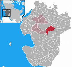
Location of Nordhastedt within Dithmarschen district
54°10′20″N 9°11′03″E / 54.17222°N 9.18417°E / 54.17222; 9.18417
(2022-12-31)[1]
25785
land.de
Nordhastedt is a municipality in the district of Dithmarschen, in Schleswig-Holstein, Germany.
-
 Katharinenkirche
 -
 "Ole Schriewerie"
 -
 Maria-Jessen-School
 -
 Train station
 -
 Town entrance sign


Notable people
- Friedrich Wiese (1892-1975) German Wehrmacht general during World War II
References
- ^ "Bevölkerung der Gemeinden in Schleswig-Holstein 4. Quartal 2022" (XLS) (in German). Statistisches Amt für Hamburg und Schleswig-Holstein.
Wikimedia Commons has media related to Nordhastedt.
- v
- t
- e
Towns and municipalities of Dithmarschen
- Albersdorf
- Arkebek
- Averlak
- Bargenstedt
- Barkenholm
- Barlt
- Bergewöhrden
- Brickeln
- Brunsbüttel
- Buchholz
- Bunsoh
- Burg
- Busenwurth
- Büsum
- Büsumer Deichhausen
- Dellstedt
- Delve
- Diekhusen-Fahrstedt
- Dingen
- Dörpling
- Eddelak
- Eggstedt
- Elpersbüttel
- Epenwöhrden
- Fedderingen
- Frestedt
- Friedrichsgabekoog
- Friedrichskoog
- Gaushorn
- Glüsing
- Großenrade
- Groven
- Gudendorf
- Hedwigenkoog
- Heide
- Hellschen-Heringsand-Unterschaar
- Helse
- Hemme
- Hemmingstedt
- Hennstedt
- Hillgroven
- Hochdonn
- Hollingstedt
- Hövede
- Immenstedt
- Kaiser-Wilhelm-Koog
- Karolinenkoog
- Kleve
- Krempel
- Kronprinzenkoog
- Krumstedt
- Kuden
- Lehe
- Lieth
- Linden
- Lohe-Rickelshof
- Lunden
- Marnerdeich
- Marne
- Meldorf
- Neuenkirchen
- Neufeld
- Neufelderkoog
- Nindorf
- Norddeich
- Norderheistedt
- Nordermeldorf
- Norderwöhrden
- Nordhastedt
- Odderade
- Oesterdeichstrich
- Oesterwurth
- Offenbüttel
- Osterrade
- Ostrohe
- Pahlen
- Quickborn
- Ramhusen
- Rehm-Flehde-Bargen
- Reinsbüttel
- Sankt Annen
- Sankt Michaelisdonn
- Sarzbüttel
- Schafstedt
- Schalkholz
- Schlichting
- Schmedeswurth
- Schrum
- Schülp
- Stelle-Wittenwurth
- Strübbel
- Süderdeich
- Süderdorf
- Süderhastedt
- Süderheistedt
- Tellingstedt
- Tensbüttel-Röst
- Tielenhemme
- Trennewurth
- Volsemenhusen
- Wallen
- Warwerort
- Weddingstedt
- Welmbüttel
- Wennbüttel
- Wesselburen
- Wesselburener Deichhausen
- Wesselburenerkoog
- Wesseln
- Westerborstel
- Westerdeichstrich
- Wiemerstedt
- Windbergen
- Wöhrden
- Wolmersdorf
- Wrohm

Authority control databases | |
|---|---|
| International |
|
| National |
|
 | This Dithmarschen location article is a stub. You can help Wikipedia by expanding it. |
- v
- t
- e


