Novovolynsk
City in Volyn Oblast, Ukraine
City of regional significance in Volyn Oblast, Ukraine
Novovolynsk Нововолинськ | |
|---|---|
City of regional significance | |
 | |
 Flag  Coat of arms | |
50°44′00″N 24°10′00″E / 50.73333°N 24.16667°E / 50.73333; 24.16667 | |
| Country |  Ukraine Ukraine |
| Oblast | Volyn Oblast |
| Raion | Volodymyr Raion |
| Hromada | Novovolynsk urban hromada |
| Founded | 1951 |
| City status | 1957 |
| Government | |
| • Mayor | Borys Karpus |
| Area | |
| • Total | 17 km2 (7 sq mi) |
| Population (2022) | |
| • Total | 49,772 |
| Postal code | 45400 |
| Area code | +380-3344 |
| Website | http://nvip.com.ua/ http://forum.novovolynsk.com.ua/ http://newvol.com.ua/ |
Novovolynsk (Ukrainian: Нововолинськ) is a city in Volyn Oblast, Ukraine. Novovolynsk, together with the rural settlement of Blahodatne and six villages, is incorporated into Novovolynsk urban hromada. Population: 49,772 (2022 estimate).[1]
Located within the Lviv-Volyn coal basin until recently, Novovolynsk was a major coal mining center of the region. The city has a few factories: a ferroconcrete plant, brickworks, a plant for mining equipment maintenance, a meatpacking and bread factory, and a woodworking plant.
History
Novovolynsk was built in 1950 as a mining town in the USSR. It obtained city status in 1957. The word "Novovolynsk" is a morphological blend, meaning "a new town in the Volyn Oblast".
There is a monument to a famous Ukrainian poet and artist Taras Shevchenko in Novovolynsk. Prominent civil society activist Anna Garmash is also from Novovolynsk, as well as footballer Artem Fedetskyi.
The town is twinned with Hartlepool, England and Echirolles, France.
Geography
Novovolynsk is situated in the southwest of Volyn Oblast in the far north-west of Ukraine. The city area is about 17 square kilometers. The state border to Poland runs 15 km to the West from the city; 92 km to the North from Novovolynsk there is the state border to Belarus.
The city is well-situated. The distance to the national highway H22 Ustyluh – Lutsk – Rivne is only 18 km. The distance to the international highway E373 (coincides with national M07) Warsaw – Lublin – Kovel – Sarny – Korosten – Kyiv is only 76 km.
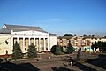
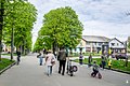
Gallery


References
- ^ Чисельність наявного населення України на 1 січня 2022 [Number of Present Population of Ukraine, as of January 1, 2022] (PDF) (in Ukrainian and English). Kyiv: State Statistics Service of Ukraine. Archived (PDF) from the original on 4 July 2022.
Sources
- (in Ukrainian) Олександр Цинкаловський. Стара Волинь і Волинське Полісся. Краєзнавчий словник — від найдавніших часів до 1914 року. – V. 1.
External links
- Novovolynsk ads
- Information portal of Novovolynsk
- Novovolynsk, Google maps


| Authority control databases: National |
|
|---|
50°44′N 24°10′E / 50.733°N 24.167°E / 50.733; 24.167


