Olmeneta
Comune in Lombardy, Italy
Olmeneta Ulmenéeda (Lombard) | |
|---|---|
Comune | |
| Comune di Olmeneta | |
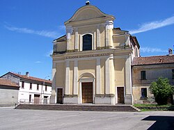 San Giovanni Battista, Olmeneta | |
Location of Olmeneta  | |
45°14′N 10°1′E / 45.233°N 10.017°E / 45.233; 10.017 | |
| Country | Italy |
| Region | Lombardy |
| Province | Cremona (CR) |
| Government | |
| • Mayor | Renzo Felisari |
| Area | |
| • Total | 9.2 km2 (3.6 sq mi) |
| Elevation | 55 m (180 ft) |
| Population (28 February 2017)[2] | |
| • Total | 947 |
| • Density | 100/km2 (270/sq mi) |
| Time zone | UTC+1 (CET) |
| • Summer (DST) | UTC+2 (CEST) |
| Postal code | 26010 |
| Dialing code | 0372 |
Olmeneta (Cremunés: Ulmenéeda) is a comune (municipality) in the Province of Cremona in the Italian region Lombardy, located about 70 kilometres (43 mi) southeast of Milan and about 11 kilometres (7 mi) north of Cremona.
Olmeneta borders the following municipalities: Casalbuttano ed Uniti, Castelverde, Corte de' Cortesi con Cignone, Pozzaglio ed Uniti, Robecco d'Oglio.
San Giovanni Battista is the Roman Catholic parish church of the town.
Transportation
Olmeneta has a railway station which is a junction of the lines Brescia–Cremona and Treviglio–Cremona.
References
- v
- t
- e
- Acquanegra Cremonese
- Agnadello
- Annicco
- Azzanello
- Bagnolo Cremasco
- Bonemerse
- Bordolano
- Ca' d'Andrea
- Calvatone
- Camisano
- Campagnola Cremasca
- Capergnanica
- Cappella Cantone
- Cappella de' Picenardi
- Capralba
- Casalbuttano ed Uniti
- Casale Cremasco-Vidolasco
- Casaletto Ceredano
- Casaletto Vaprio
- Casaletto di Sopra
- Casalmaggiore
- Casalmorano
- Castel Gabbiano
- Casteldidone
- Castelleone
- Castelverde
- Castelvisconti
- Cella Dati
- Chieve
- Cicognolo
- Cingia de' Botti
- Corte de' Cortesi con Cignone
- Corte de' Frati
- Credera Rubbiano
- Crema
- Cremona
- Cremosano
- Crotta d'Adda
- Cumignano sul Naviglio
- Derovere
- Dovera
- Drizzona
- Fiesco
- Formigara
- Gabbioneta-Binanuova
- Gadesco-Pieve Delmona
- Genivolta
- Gerre de' Caprioli
- Gombito
- Grontardo
- Grumello Cremonese ed Uniti
- Gussola
- Isola Dovarese
- Izano
- Madignano
- Malagnino
- Martignana di Po
- Monte Cremasco
- Montodine
- Moscazzano
- Motta Baluffi
- Offanengo
- Olmeneta
- Ostiano
- Paderno Ponchielli
- Palazzo Pignano
- Pandino
- Persico Dosimo
- Pescarolo ed Uniti
- Pessina Cremonese
- Piadena
- Pianengo
- Pieranica
- Pieve San Giacomo
- Pieve d'Olmi
- Pizzighettone
- Pozzaglio ed Uniti
- Quintano
- Ricengo
- Ripalta Arpina
- Ripalta Cremasca
- Ripalta Guerina
- Rivarolo del Re ed Uniti
- Rivolta d'Adda
- Robecco d'Oglio
- Romanengo
- Salvirola
- San Bassano
- San Daniele Po
- San Giovanni in Croce
- San Martino del Lago
- Scandolara Ravara
- Scandolara Ripa d'Oglio
- Sergnano
- Sesto ed Uniti
- Solarolo Rainerio
- Soresina
- Sospiro
- Soncino
- Spinadesco
- Spineda
- Spino d'Adda
- Stagno Lombardo
- Ticengo
- Torlino Vimercati
- Tornata
- Torre de' Picenardi
- Torricella del Pizzo
- Trescore Cremasco
- Trigolo
- Vaiano Cremasco
- Vailate
- Vescovato
- Volongo
- Voltido
 | This article on a location in the Province of Cremona is a stub. You can help Wikipedia by expanding it. |
- v
- t
- e


