Rabo de Junco

Rabo de Junco
western Sal
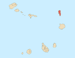
Rabo de Junco (also: Monte Leão) is a hill on the west coast of the island of Sal in Cape Verde. It is situated at the northern end of the Baía da Murdeira, 8 kilometres (5.0 mi) southwest of the island capital Espargos. Its steep eroded south face towards the bay is an important nesting area for birds. Rabo de Junco and the surrounding 154 hectares (380 acres) are protected as a nature reserve.[3][2] It was mentioned as Rabadyunk in the 1747 map by Jacques-Nicolas Bellin.[4] To its west lies the uninhabited islet Ilhéu Rabo de Junco.
See also
References
- v
- t
- e
The island of Sal, Cape Verde
- Espargos
- Murdeira
- Palmeira
- Pedra de Lume
- Santa Maria
- Terra Boa
- Morrinho de Açúcar
- Cagarral
- Monte Curral
- Monte Grande
- Rabo de Junco
- Serra Negra
- Ponta da Fragata
- Ponta do Leme Velho
- Ponta Norte
- Ponta Preta (Northern Sal)
- Ponta Preta (Southern Sal)
- Ponta do Sinó
- Ponta de Vera Cruz
 | This Cape Verdean location article is a stub. You can help Wikipedia by expanding it. |
- v
- t
- e


