Rodrigues Alves, Acre
07°44′31″S 72°38′49″W / 7.74194°S 72.64694°W / -7.74194; -72.64694
Place in Acre, Brazil

Flag
Seal
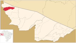
Location of municipality in Acre State


Rodrigues Alves, Acre
Location in Brazil
 Brazil
 (2020 est [1])
Rodrigues Alves (Portuguese pronunciation: [ʁoˈdɾiɡiz ˈawvis]) is a municipality located in the west of the Brazilian state of Acre. Its population is 19,351 according to the 2020 estimates.

The municipality contains 13.45% of the 846,633 hectares (2,092,080 acres) Serra do Divisor National Park, created in 1989.[2]
Population

References
External links
- Rodrigues Alves' municipal government
- v
- t
- e

Capital: Rio Branco
- Assis Brasil
- Brasiléia
- Epitaciolândia
- Xapuri

- Acrelândia
- Bujari
- Capixaba
- Plácido de Castro
- Porto Acre
- Rio Branco
- Senador Guiomard
- Cruzeiro do Sul
- Mâncio Lima
- Marechal Thaumaturgo
- Porto Walter
- Rodrigues Alves
 | This Acre, Brazil location article is a stub. You can help Wikipedia by expanding it. |
- v
- t
- e


