Sáric Municipality
You can help expand this article with text translated from the corresponding article in Spanish. (August 2012) Click [show] for important translation instructions.
- View a machine-translated version of the Spanish article.
- Machine translation, like DeepL or Google Translate, is a useful starting point for translations, but translators must revise errors as necessary and confirm that the translation is accurate, rather than simply copy-pasting machine-translated text into the English Wikipedia.
- Do not translate text that appears unreliable or low-quality. If possible, verify the text with references provided in the foreign-language article.
- You must provide copyright attribution in the edit summary accompanying your translation by providing an interlanguage link to the source of your translation. A model attribution edit summary is
Content in this edit is translated from the existing Spanish Wikipedia article at [[:es:Sáric (municipio)]]; see its history for attribution. - You may also add the template
{{Translated|es|Sáric (municipio)}}to the talk page. - For more guidance, see Wikipedia:Translation.
Municipality in Sonora, Mexico
Seal
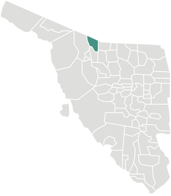
Location of the municipality in Sonora.
 Mexico
 (2005)
Sáric Municipality is a municipality in the Mexican state of Sonora in north-western Mexico.[1] Its northern boundary is the U.S. state of Arizona. The population of the municipality (urban and rural areas) was 2,703 in 2010 living in an area of 1,676.23 square kilometers. The elevation is around 800 meters. At the municipal seat it is 780 meters.
Name
The Spanish name of the town derives from the O'odham name, Ṣaʼalk, which means "mountain pass".[2]
Geography
Boundaries are with Pima County and Santa Cruz County in the U.S. state of Arizona to the north; Nogales, Sonora, to the east; Tubutama to the south; Altar to the west; and Magdalena de Kino to the southeast.
The only settlements of over 100 population were Sáric (892) 31°06′11″N 111°22′40″W / 31.10306°N 111.37778°W / 31.10306; -111.37778, El Sásabe (1,295) 31°28′19″N 111°32′39″W / 31.47194°N 111.54417°W / 31.47194; -111.54417, and Cierro Prieto (353) 31°01′13″N 111°23′43″W / 31.02028°N 111.39528°W / 31.02028; -111.39528, as enumerated in the 2010 census. There is an international border crossing leading to Sasabe, Arizona.
The land is high desert with extreme temperatures in the summer months. The Altar River has its source north of the municipality in the Arizona mountains and flows south.
Economy
The desert lands are poor and agriculture can only be practiced in the Altar River valley where wheat, corn, alfalfa, sorghum, and rye grass are grown. Extensive cattle raising is carried out.
References
- 2010 census tables: INEGI
External links
- Sáric, Ayuntamiento Digital (Official Website of Sáric, Sonora)
Places adjacent to Sáric Municipality | |
|---|---|


- v
- t
- e
 State of Sonora
Hermosillo (capital)

and
(municipal seats)
- Aconchi (Aconchi)
- Agua Prieta (Agua Prieta)
- Álamos (Álamos)
- Altar (Altar)
- Arivechi (Arivechi)
- Arizpe (Arizpe)
- Atil (Atil)
- Bacadéhuachi (Bacadéhuachi)
- Bacanora (Bacanora)
- Bacerac (Bacerac)
- Bacoachi (Bacoachi)
- Bácum (Bácum)
- Banámichi (Banámichi)
- Baviácora (Baviácora)
- Bavispe (Bavispe)
- Benito Juárez (Villa Juárez)
- Benjamín Hill (Benjamín Hill)
- Caborca (Heroica Caborca)
- Cajeme (Ciudad Obregón)
- Cananea (Cananea)
- Carbó (Carbó)
- Cucurpe (Cucurpe)
- Cumpas (Cumpas)
- Divisaderos (Divisaderos)
- Empalme (Empalme)
- Etchojoa (Etchojoa)
- Fronteras (Fronteras)
- Granados (Granados)
- Guaymas (Guaymas)
- Hermosillo (Hermosillo)
- Huachinera (Huachinera)
- Huásabas (Huásabas)
- Huatabampo (Huatabampo)
- Huépac (Huépac)
- Imuris (Imuris)
- La Colorada (La Colorada)
- Magdalena de Kino (Magdalena de Kino)
- Mazatán (Mazatán)
- Moctezuma (Moctezuma)
- Naco (Naco)
- Nácori Chico (Nácori Chico)
- Nacozari de García (Nacozari de García)
- Navojoa (Navojoa)
- Nogales (Nogales)
- Onavas (Onavas)
- Opodepe (Opodepe)
- Oquitoa (Oquitoa)
- Pitiquito (Pitiquito)
- Puerto Peñasco (Puerto Peñasco)
- Plutarco Elías Calles (Sonoyta)
- Quiriego (Quiriego)
- Rayón (Rayón)
- Rosario de Tesopaco (Rosario de Tesopaco)
- Sahuaripa (Sahuaripa)
- San Felipe de Jesús (San Felipe de Jesús)
- San Ignacio Río Muerto (San Ignacio Río Muerto)
- San Javier (San Javier)
- San Luis Río Colorado (San Luis Río Colorado)
- San Miguel de Horcasitas (San Miguel de Horcasitas)
- San Pedro de la Cueva (San Pedro de la Cueva)
- Santa Ana (Santa Ana)
- Santa Cruz (Santa Cruz)
- Sáric (Sáric)
- Soyopa (Soyopa)
- Suaqui Grande (Suaqui Grande)
- Tepache (Tepache)
- Trincheras (Trincheras)
- Tubutama (Tubutama)
- Ures (Ures)
- Villa Hidalgo (Villa Hidalgo)
- Villa Pesqueira (Villa Pesqueira)
- Yécora (Yécora)
31°13′57″N 111°25′42″W / 31.2326°N 111.4283°W / 31.2326; -111.4283


