Saint-Étienne-de-Crossey
You can help expand this article with text translated from the corresponding article in French. (December 2009) Click [show] for important translation instructions.
- View a machine-translated version of the French article.
- Machine translation, like DeepL or Google Translate, is a useful starting point for translations, but translators must revise errors as necessary and confirm that the translation is accurate, rather than simply copy-pasting machine-translated text into the English Wikipedia.
- Do not translate text that appears unreliable or low-quality. If possible, verify the text with references provided in the foreign-language article.
- You must provide copyright attribution in the edit summary accompanying your translation by providing an interlanguage link to the source of your translation. A model attribution edit summary is
Content in this edit is translated from the existing French Wikipedia article at [[:fr:Saint-Étienne-de-Crossey]]; see its history for attribution. - You may also add the template
{{Translated|fr|Saint-Étienne-de-Crossey}}to the talk page. - For more guidance, see Wikipedia:Translation.
Commune in Auvergne-Rhône-Alpes, France
Saint-Étienne-de-Crossey | ||
|---|---|---|
Commune | ||
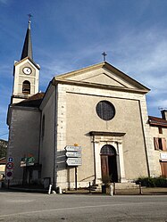 The church of Saint-Étienne-de-Crossey | ||
Location of Saint-Étienne-de-Crossey  | ||
(2020–2026) Ghislaine Peylin[1] | | |
| Area 1 | 12.84 km2 (4.96 sq mi) | |
| Population (2021)[2] | 2,587 | |
| • Density | 200/km2 (520/sq mi) | |
| Time zone | UTC+01:00 (CET) | |
| • Summer (DST) | UTC+02:00 (CEST) | |
| INSEE/Postal code | 38383 /38960 | |
| Elevation | 370–883 m (1,214–2,897 ft) (avg. 451 m or 1,480 ft) | |
| 1 French Land Register data, which excludes lakes, ponds, glaciers > 1 km2 (0.386 sq mi or 247 acres) and river estuaries. | ||
Saint-Étienne-de-Crossey (French pronunciation: [sɛ̃.t‿etjɛn də kʁɔsɛ]) is a commune in the Isère department in southeastern France.[3]
Population
|
| ||||||||||||||||||||||||||||||||||||||||||||||||||||||
| Source: EHESS[4] and INSEE (1968-2017)[5] | |||||||||||||||||||||||||||||||||||||||||||||||||||||||
See also
References
Wikimedia Commons has media related to Saint-Étienne-de-Crossey.
- ^ "Répertoire national des élus: les maires". data.gouv.fr, Plateforme ouverte des données publiques françaises (in French). 9 August 2021.
- ^ "Populations légales 2021". The National Institute of Statistics and Economic Studies. 28 December 2023.
- ^ INSEE commune file
- ^ Des villages de Cassini aux communes d'aujourd'hui: Commune data sheet Saint-Étienne-de-Crossey, EHESS (in French).
- ^ Population en historique depuis 1968, INSEE
- v
- t
- e

- Les Abrets en Dauphiné
- Les Adrets
- Agnin
- L'Albenc
- Allemond
- Allevard
- Ambel
- Anjou
- Annoisin-Chatelans
- Anthon
- Aoste
- Apprieu
- Arandon-Passins
- Artas
- Assieu
- Auberives-en-Royans
- Auberives-sur-Varèze
- Auris
- Autrans-Méaudre-en-Vercors
- Les Avenières-Veyrins-Thuellin
- Avignonet
- La Balme-les-Grottes
- Barraux
- La Bâtie-Montgascon
- Beaucroissant
- Beaufin
- Beaufort
- Beaulieu
- Beaurepaire
- Beauvoir-de-Marc
- Beauvoir-en-Royans
- Bellegarde-Poussieu
- Belmont
- Bernin
- Besse
- Bessins
- Bévenais
- Bilieu
- Biol
- Biviers
- Bizonnes
- Blandin
- Bonnefamille
- Bossieu
- Le Bouchage
- Bougé-Chambalud
- Le Bourg-d'Oisans
- Bourgoin-Jallieu
- Bouvesse-Quirieu
- Brangues
- Bressieux
- Bresson
- Brézins
- Brié-et-Angonnes
- Brion
- La Buisse
- La Buissière
- Burcin
- Cessieu
- Châbons
- Chalon
- Chamagnieu
- Champagnier
- Champier
- Le Champ-près-Froges
- Champ-sur-Drac
- Chamrousse
- Chanas
- Chantepérier
- Chantesse
- Chapareillan
- La Chapelle-de-la-Tour
- La Chapelle-de-Surieu
- La Chapelle-du-Bard
- Charancieu
- Charantonnay
- Charavines
- Charette
- Charnècles
- Charvieu-Chavagneux
- Chasse-sur-Rhône
- Chasselay
- Chassignieu
- Château-Bernard
- Châteauvilain
- Châtel-en-Trièves
- Châtelus
- Châtenay
- Châtonnay
- Chatte
- Chavanoz
- Chélieu
- Chevrières
- Le Cheylas
- Cheyssieu
- Chèzeneuve
- Chichilianne
- Chimilin
- Chirens
- Cholonge
- Chonas-l'Amballan
- Choranche
- Chozeau
- Chuzelles
- Claix
- Clavans-en-Haut-Oisans
- Clelles
- Clonas-sur-Varèze
- Cognet
- Cognin-les-Gorges
- Colombe
- La Combe-de-Lancey
- Corbelin
- Corenc
- Cornillon-en-Trièves
- Corps
- Corrençon-en-Vercors
- La Côte-Saint-André
- Les Côtes-d'Arey
- Les Côtes-de-Corps
- Coublevie
- Cour-et-Buis
- Courtenay
- Crachier
- Cras
- Crémieu
- Crêts en Belledonne
- Creys-Mépieu
- Crolles
- Culin
- Les Deux Alpes
- Diémoz
- Dizimieu
- Doissin
- Dolomieu
- Domarin
- Domène
- Échirolles
- Eclose-Badinières
- Engins
- Entraigues
- Entre-deux-Guiers
- Les Éparres
- Estrablin
- Eybens
- Eydoche
- Eyzin-Pinet
- Faramans
- Faverges-de-la-Tour
- La Flachère
- Flachères
- Fontaine
- Fontanil-Cornillon
- La Forteresse
- Four
- Le Freney-d'Oisans
- La Frette
- Froges
- Frontonas
- La Garde
- Gières
- Gillonnay
- Goncelin
- Le Grand-Lemps
- Granieu
- Grenay
- Grenoblepref
- Gresse-en-Vercors
- Le Gua
- Le Haut-Bréda
- Herbeys
- Heyrieux
- Hières-sur-Amby
- Huez
- Hurtières
- L'Isle-d'Abeau
- Izeaux
- Izeron
- Janneyrias
- Jarcieu
- Jardin
- Jarrie
- Laffrey
- Lalley
- Lans-en-Vercors
- Lavaldens
- Laval-en-Belledonne
- Lavars
- Lentiol
- Leyrieu
- Lieudieu
- Livet-et-Gavet
- Longechenal
- Lumbin
- Luzinay
- Malleval-en-Vercors
- Marcieu
- Marcilloles
- Marcollin
- Marnans
- Massieu
- Maubec
- Mayres-Savel
- Mens
- Merlas
- Meylan
- Meyrié
- Meyrieu-les-Étangs
- Meyssiez
- Miribel-Lanchâtre
- Miribel-les-Échelles
- Mizoën
- Moidieu-Détourbe
- Moirans
- Moissieu-sur-Dolon
- Monestier-d'Ambel
- Monestier-de-Clermont
- Monestier-du-Percy
- Monsteroux-Milieu
- Montagne
- Montagnieu
- Montalieu-Vercieu
- Montaud
- Montbonnot-Saint-Martin
- Montcarra
- Montchaboud
- Monteynard
- Montfalcon
- Montferrat
- Montrevel
- Mont-Saint-Martin
- Montseveroux
- Moras
- Morestel
- Morette
- La Morte
- La Motte-d'Aveillans
- La Motte-Saint-Martin
- Mottier
- Le Moutaret
- La Mure
- La Murette
- Murianette
- Murinais
- Nantes-en-Ratier
- Nivolas-Vermelle
- Notre-Dame-de-Commiers
- Notre-Dame-de-l'Osier
- Notre-Dame-de-Mésage
- Notre-Dame-de-Vaulx
- Noyarey
- Optevoz
- Oris-en-Rattier
- Ornacieux-Balbins
- Ornon
- Oulles
- Oyeu
- Oytier-Saint-Oblas
- Oz
- Pact
- Pajay
- Panossas
- Parmilieu
- Le Passage
- Le Péage-de-Roussillon
- Pellafol
- Penol
- Le Percy
- La Pierre
- Pierre-Châtel
- Pisieu
- Plan
- Plateau-des-Petites-Roches
- Poisat
- Poliénas
- Pommier-de-Beaurepaire
- Ponsonnas
- Pontcharra
- Le Pont-de-Beauvoisin
- Pont-de-Chéruy
- Le Pont-de-Claix
- Pont-en-Royans
- Pont-Évêque
- Porcieu-Amblagnieu
- Porte-des-Bonnevaux
- Prébois
- Presles
- Pressins
- Primarette
- Proveysieux
- Prunières
- Quaix-en-Chartreuse
- Quet-en-Beaumont
- Quincieu
- Réaumont
- Renage
- Rencurel
- Revel
- Revel-Tourdan
- Reventin-Vaugris
- Rives
- La Rivière
- Roche
- Les Roches-de-Condrieu
- Rochetoirin
- Roissard
- Romagnieu
- Roussillon
- Rovon
- Royas
- Roybon
- Ruy-Montceau
- Sablons
- Saint-Agnin-sur-Bion
- Saint-Alban-de-Roche
- Saint-Alban-du-Rhône
- Saint-Albin-de-Vaulserre
- Saint-Andéol
- Saint-André-en-Royans
- Saint-André-le-Gaz
- Saint Antoine l'Abbaye
- Saint-Appolinard
- Saint-Arey
- Saint-Aupre
- Saint-Barthélemy
- Saint-Barthélemy-de-Séchilienne
- Saint-Baudille-de-la-Tour
- Saint-Baudille-et-Pipet
- Saint-Blaise-du-Buis
- Saint-Bonnet-de-Chavagne
- Saint-Bueil
- Saint-Cassien
- Saint-Chef
- Saint-Christophe-en-Oisans
- Saint-Christophe-sur-Guiers
- Saint-Clair-de-la-Tour
- Saint-Clair-du-Rhône
- Saint-Clair-sur-Galaure
- Saint-Didier-de-Bizonnes
- Saint-Didier-de-la-Tour
- Sainte-Agnès
- Sainte-Anne-sur-Gervonde
- Sainte-Blandine
- Saint-Égrève
- Sainte-Luce
- Sainte-Marie-d'Alloix
- Sainte-Marie-du-Mont
- Saint-Étienne-de-Crossey
- Saint-Étienne-de-Saint-Geoirs
- Saint-Geoire-en-Valdaine
- Saint-Geoirs
- Saint-Georges-de-Commiers
- Saint-Georges-d'Espéranche
- Saint-Gervais
- Saint-Guillaume
- Saint-Hilaire-de-Brens
- Saint-Hilaire-de-la-Côte
- Saint-Hilaire-du-Rosier
- Saint-Honoré
- Saint-Ismier
- Saint-Jean-d'Avelanne
- Saint-Jean-de-Bournay
- Saint-Jean-de-Moirans
- Saint-Jean-de-Soudain
- Saint-Jean-de-Vaulx
- Saint-Jean-d'Hérans
- Saint-Jean-le-Vieux
- Saint-Joseph-de-Rivière
- Saint-Julien-de-l'Herms
- Saint-Just-Chaleyssin
- Saint-Just-de-Claix
- Saint-Lattier
- Saint-Laurent-du-Pont
- Saint-Laurent-en-Beaumont
- Saint-Marcel-Bel-Accueil
- Saint-Marcellin
- Saint-Martin-de-Clelles
- Saint-Martin-de-la-Cluze
- Saint-Martin-de-Vaulserre
- Saint-Martin-d'Hères
- Saint-Martin-d'Uriage
- Saint-Martin-le-Vinoux
- Saint-Maurice-en-Trièves
- Saint-Maurice-l'Exil
- Saint-Maximin
- Saint-Michel-de-Saint-Geoirs
- Saint-Michel-en-Beaumont
- Saint-Michel-les-Portes
- Saint-Mury-Monteymond
- Saint-Nazaire-les-Eymes
- Saint-Nicolas-de-Macherin
- Saint-Nizier-du-Moucherotte
- Saint-Ondras
- Saint-Paul-de-Varces
- Saint-Paul-d'Izeaux
- Saint-Paul-lès-Monestier
- Saint-Pierre-de-Bressieux
- Saint-Pierre-de-Chartreuse
- Saint-Pierre-de-Chérennes
- Saint-Pierre-de-Méaroz
- Saint-Pierre-de-Mésage
- Saint-Pierre-d'Entremont
- Saint-Prim
- Saint-Quentin-Fallavier
- Saint-Quentin-sur-Isère
- Saint-Romain-de-Jalionas
- Saint-Romain-de-Surieu
- Saint-Romans
- Saint-Sauveur
- Saint-Savin
- Saint-Siméon-de-Bressieux
- Saint-Sorlin-de-Morestel
- Saint-Sorlin-de-Vienne
- Saint-Sulpice-des-Rivoires
- Saint-Théoffrey
- Saint-Vérand
- Saint-Victor-de-Cessieu
- Saint-Victor-de-Morestel
- Saint-Vincent-de-Mercuze
- Salagnon
- Salaise-sur-Sanne
- La Salette-Fallavaux
- La Salle-en-Beaumont
- Le Sappey-en-Chartreuse
- Sarcenas
- Sardieu
- Sassenage
- Satolas-et-Bonce
- Savas-Mépin
- Séchilienne
- Septème
- Sérézin-de-la-Tour
- Sermérieu
- Serpaize
- Serre-Nerpol
- Seyssinet-Pariset
- Seyssins
- Seyssuel
- Siccieu-Saint-Julien-et-Carisieu
- Siévoz
- Sillans
- Sinard
- Soleymieu
- La Sône
- Sonnay
- Sousville
- Succieu
- La Sure en Chartreuse
- Susville
- Têche
- Tencin
- La Terrasse
- Theys
- Thodure
- Tignieu-Jameyzieu
- Torchefelon
- La Tour-du-Pinsubpr
- Le Touvet
- Tramolé
- Treffort
- Tréminis
- Trept
- La Tronche
- Tullins
- Valbonnais
- Val-de-Virieu
- Valencin
- Valencogne
- La Valette
- Valjouffrey
- Varacieux
- Varces-Allières-et-Risset
- Vasselin
- Vatilieu
- Vaujany
- Vaulnaveys-le-Bas
- Vaulnaveys-le-Haut
- Vaulx-Milieu
- Velanne
- Vénérieu
- Venon
- Vernas
- Vernioz
- La Verpillière
- Le Versoud
- Vertrieu
- Veurey-Voroize
- Veyssilieu
- Vézeronce-Curtin
- Viennesubpr
- Vif
- Vignieu
- Villages du Lac de Paladru
- Villard-Bonnot
- Villard-de-Lans
- Villard-Notre-Dame
- Villard-Reculas
- Villard-Reymond
- Villard-Saint-Christophe
- Villefontaine
- Villemoirieu
- Villeneuve-de-Marc
- Ville-sous-Anjou
- Villette-d'Anthon
- Villette-de-Vienne
- Vinay
- Viriville
- Vizille
- Voiron
- Voissant
- Voreppe
- Vourey
- pref: prefecture
- subpr: subprefecture
Authority control databases | |
|---|---|
| International |
|
| National |
|
 | This Isère geographical article is a stub. You can help Wikipedia by expanding it. |
- v
- t
- e


