Saint-Stanislas, Mauricie, Quebec
Municipality in Quebec, Canada
46°37′N 72°24′W / 46.617°N 72.400°W / 46.617; -72.400 Canada
 Quebec
 (2011)
 0.4%
0.4% R-159
R-159  R-352
R-352Saint-Stanislas, old name Deux-Rivières (Village), is a municipality part of Les Chenaux Regional County Municipality, in Mauricie, Quebec, Canada.
Geography - Geology
The territory of Saint-Stanislas is set ablaze in gigantic geographical and geological formations: on the Canadian Shield, at the foot of the Laurentian mountain range, on the north shore of the St. Lawrence River, in the Saint-Narcisse moraine, the boreal forest, among other elements.
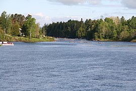
The municipality was established on both sides of the Batiscan River, at the confluence of the Rivière des Envies, about twenty kilometres from the St. Lawrence River, in Batiscanie, the vernacular name of an undefined territory.
Saint-Stanislas is part of this group of parishes that historians describe as the first pioneer front of the Mauricie region in the nineteenth century.[1]'[2]'[3] (Photos)
History
Down the current of Quebec's rivers
In the early 1800s, in Quebec, mainly in the Outaouais, Mauricie and Saguenay–Lac-Saint-Jean regions, attempts to transport wood by water began. In Batiscanie, the parish of Saint-Stanislas has a large reservoir of labour for work in rivers and forests.
The village area of Saint-Stanislas is said to have had 422 inhabitants as early as 1851 and 593 twenty years later. Beginning in 1852, Price Brothers and Company exploited the forest of the Batiscan Valley. Several sawmills were built on the Batiscan and des Envies rivers.
The presence of sawmilling facilities and the development of logging throughout the Saint-Maurice River basin allowed Saint-Stanislas to establish itself as the main basin for labour and forestry subcontracting until about 1870, before being overtaken by that of Saint-Tite, located further north, in the Laurentian mountains.

The timber was transported by floating, down the current of the rivers, which required the work of cages and log drivers (Cajeux - Draveurs). The first types of trees cut were — Pin blanc L. — Pinus strobus. — White pine (eastern white pine)., shipped to Great Britain.
- The cageux, this Ulysses of the St. Lawrence River, and tributarys St-Maurice, Batiscan, Saguenay, Jacques-Cartier, Sainte-Anne (Les Chenaux) as exemples, was responsible for assembling the rafts and piloting the huge wooden train made of squared pine — also called a cage — to a port of embarkation.
- The log driver, a daring tightrope walker of the rivers, was responsible for controlling the free floating of cut tree trunks that were thrown into a watercourse in order to reach a sawmill or a pulp and paper mill.[5]
The settlers who had already established themselves took advantage of the proximity of the construction sites to sell their agricultural production and at the same time provided a workforce for whom working in the forest represented an additional income.[2]'[6]'[7]
Demographics
Population trend:[8]
| Year | Population | Variation (%) |
|---|---|---|
| 2011 | 1,029 | -0,4 % |
| 2006 | 1,033 | -0,4 % |
| 2001 | 1,076 | -8,3 % |
| 1996 | 1,174 | % |
| 1991 | % | |
| 1986 | - |
Others statistics based on 2011 Canadian Census:
Private dwellings occupied by usual residents: 504 (total dwellings: 509)
Mother language of Saint-Stanislas's citizens:
- French as first language: 98.6%
- English as first language: 0.5%
- English and French as first language: 1.0%
- Other as first language: 0%
In 2011 Census, 175 particulars declared themselves as bilingual (English & French), 845 speaking French only and 5 speaking English only. The median age of the population was 52.4 years in 2011. In addition, 89.2% of the population was aged 15 and over.
Photos
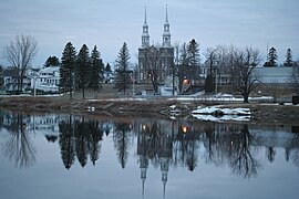
Saint-Stanislas, Mauricie, Quebec, Batiscan River
- Infrastructure and built heritage
-
 Pont sur la Rivière des Envies, rue Principale
 -
 Vieux pont de fer (Quebec Road 159)
 -
 Parish church
 -
 Parish church, presbytery, municipality
 -
 Municipality
 -
![Mill built by the Jesuits in 1781, monument erected by the Historical Society of Saint-Stanislas, road 159[9]](//upload.wikimedia.org/wikipedia/commons/thumb/3/31/Saint_Stanislas_062.jpg/240px-Saint_Stanislas_062.jpg) Mill built by the Jesuits in 1781, monument erected by the Historical Society of Saint-Stanislas, road 159[9]
Mill built by the Jesuits in 1781, monument erected by the Historical Society of Saint-Stanislas, road 159[9]


![Mill built by the Jesuits in 1781, monument erected by the Historical Society of Saint-Stanislas, road 159[9]](http://upload.wikimedia.org/wikipedia/commons/thumb/3/31/Saint_Stanislas_062.jpg/240px-Saint_Stanislas_062.jpg)
- Agricultural and rural areas
-
 Rang de la Rivière Batiscan NE
 -
 Rang de la Rivière Batiscan NE
 -
 Beach, Rang de la Rivière Batiscan NE
 -
 Rang de la Rivière Batiscan NE
 -
 Rang de la Rivière Batiscan NE


See also
- Lordship of Sainte-Anne-de-la-Pérade (Seigneurie de Sainte-Anne-de-la-Pérade)
- Lordship of Batiscan (Seigneurie de Batiscan)
- Rivière des Envies
- Batiscan River
- Batiscanie, Quebec
References
- ^ "Saint-Stanislas". Commission de toponymie Quebec (in French). Government of Quebec. 1976-12-24. Retrieved 2023-12-23.
Saint-Stanislas was part of the seigneury of Batiscan (1639) owned by the Jesuits
- ^ a b Jacques Lefebvre (March 1989). "Création et évolution de l'aire villageoise de Saint-Stanislas de la-rivière des Envies : 1827-1881" (PDF) (in French). Université du Québec à Trois-Rivières. pp. 15 of 147. Retrieved 2023-12-21.
The division of the territory, relations with the Price Company, shorts stories of families and neighbours, maps
- ^ The Canadian Encyclopedia (2021-08-06). "Canadian Shield".
Huge rock formation, stretches from Labrador to the Arctic, covering parts of Saskatchewan, Alberta, and much of Quebec, Ontario, Manitoba and the Northwest Territories
- ^ Elizabeth A. Moffatt, Marie-Claude Corbeil (2007). "The Painting Materials and Techniques of Cornelius Krieghoff (1815-1872)" (PDF). Department of Canadian Heritage and the Art Gallery of Ontario. p. 15. Retrieved 2023-12-21.
Autumn and winter landscapes, portrayals of Aboriginal people and depictions of life in rural Quebec
- ^ "200 years of exploits Cageux et draveurs". On the road to the historic motion of the National Assembly of Quebec: 200 years of exploits: cageux et draveurs (in French). Bibliothèque et Archives nationales du Québec. 2021. p. 380. Retrieved 2023-12-21.
At the time of the great voyages of exploration, the First Peoples provided assistance essential for Europeans to survive and settle in these lands
- ^ Jean Benoit (2005). "PRICE, Sir WILLIAM (1867-1924)". Dictionary of Canadian Biography, vol. 15. University of Toronto/Université Laval. Retrieved 2023-12-21.
Educated first at Bishop's College, in Lennoxville, Que., and later at St Mark's School in Windsor, England
- ^ Maude Roux-Pratte (1909–1978). "The Public Good (1909-1978): a Newspaper, a Publishing House, a Printing House, the success of a Mauricie company through its networks" (PDF) (in French). Université du Québec à Montréal. Retrieved 2023-12-14.
Founded in 1909 by the Bishop of Trois-Rivières, Mgr Reverend F. X. Cloutier
- ^ Statistics Canada: 1986, 1991, 1996, 2001, 2006, 2011 census
- ^ Audrey Leblanc (13 November 2018). "He operates an old-fashioned sawmill" (in French). L'Hebdo journal. Retrieved 2024-01-06.
the force of the moving water that powers the company built in 1860.
External links
- Historical Society, Municipality of Saint-Stanislas, list of publications (French)
- St. Lawrence River, The Canadian Encyclopedia - Historica Canada, January 1922
- Atlas de l'eau, Ministère de l’Environnement, de la Lutte contre les changements climatiques, de la Faune et des Parcs Québec, 2023 (French).
- Plan directeur de l’eau de la rivière Batiscan, Société d’aménagement et de mise en valeur du bassin de la Batiscan (SAMBBA) (2015) (French)..
- L e Coteillage (fr), Trois-Rivières 1981, recherche sur le patrimoine local et régional
- Saint-Stanislas-de-la-Rivière-des-Envies 1787-1919 (fr), Advitam, Bibliothèque et Archives nationales du Québec
- Village du bûcheron de Grandes-Piles, l’univers des bûcherons québécois d’antan (French).
- Menaud maître-draveur, Savard Félix-Antoine (1896-1982), Les Presses de l'Université de Montréal 2004 (French).
- Saint-Stanislas-de-la-Rivière-des-Envies Manuscrit 1787-1919, Bibliothèque et Archives nationales du Québec « BAnQ Trois-Rivières » (French).
- Municipalité Saint-Stanislas-de-Champlain, 1302, rue Principale, Saint-Stanislas-de-Champlain, Québec, G0X 3E0 (French).
- Société d' histoire de Saint-Stanislas, liste et accès aux ouvrages traitant de l'histoire de la municipalité, aux registres d'état civil et autres
 Media related to Saint-Stanislas, Mauricie, Quebec at Wikimedia Commons
Places adjacent to Saint-Stanislas, Mauricie, Quebec | |
|---|---|


| Authority control databases: Geographic |
|
|---|


