Sasunik
40°14′50″N 44°20′17″E / 40.24722°N 44.33806°E / 40.24722; 44.33806
Place in Aragatsotn, Armenia
Sasunik Սասունիկ | |
|---|---|
  Sasunik  Sasunik | |
| Coordinates: 40°14′50″N 44°20′17″E / 40.24722°N 44.33806°E / 40.24722; 44.33806 | |
| Country | Armenia |
| Province | Aragatsotn |
| Municipality | Ashtarak |
| Established | 1955 |
| Population (2012) | |
| • Total | 4,102[1] |
| Time zone | UTC+4 |
Sasunik (Armenian: Սասունիկ) is a village in the Ashtarak Municipality of the Aragatsotn Province of Armenia. It was founded as a collective farm in 1955, and villagers were resettled from the old village of Sasunik in 1960.
Gallery
-
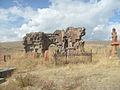 Church ruins, 7th-19th centuries
 -
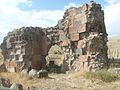 Church ruins, 7th-19th centuries
 -
 Cemetery adjacent to the church


References
- ^ World Gazetteer – Armenia[dead link]
- Sasunik at GEOnet Names Server (as Nor Sasunik)
- World Gazetteer: Armenia[dead link] – World-Gazetteer.com
- Report of the results of the 2001 Armenian Census, Statistical Committee of Armenia
External links
Wikimedia Commons has media related to Cultural heritage monuments in Verin Sasunik, Aragatsotn.
- v
- t
- e
 Aragatsotn Province
Capital: Ashtarak
- Aparan
- Ashtarak
- Talin

 | This article about a location in Aragatsotn Province, Armenia is a stub. You can help Wikipedia by expanding it. |
- v
- t
- e


