Table Mountain National Park

A nature conservation area on the Cape Peninsula in Cape Town, South Africa

Table Mountain National Park is located in South Africa
Table Mountain National Park
Table Mountain National Park (South Africa)

Table Mountain National Park, previously known as the Cape Peninsula National Park, is a national park in Cape Town, South Africa, proclaimed on 29 May 1998, for the purpose of protecting the natural environment of the Table Mountain Chain, and in particular the rare fynbos vegetation. The park is managed by South African National Parks. The property is included as part of the UNESCO Cape Floral Region World Heritage Site.

The park contains two well-known landmarks: Table Mountain, for which the park is named; and the Cape of Good Hope, the most southwestern extremity of Africa.

History

Arguments for a national park on the Cape Peninsula, centred on Table Mountain, began in earnest in the mid-1930s. The Table Mountain Preservation Board was set up in 1952, and in 1957 its recommendation to the National Monuments Board was accepted and Table Mountain was declared a national monument. In the mid 1960s, the Cape Town City Council declared nature reserves on Table Mountain, Lion's Head, Signal Hill, and Silvermine. Following high fire incidence in the 1970s, Douglas Hey was appointed to assess the ecological state of Table Mountain and the southern Peninsula, and he recommended (1978) that all the Peninsula's mountains above 152m should be conserved. This laid the foundations for the Cape Peninsula Protected Natural Environment (CPPNE) area, finally established in 1989. However, environmental management was still bedevilled by the fragmented nature of land ownership on the Peninsula. Following a big fire above the city bowl in 1991, Attorney General Frank Kahn was appointed to reach consensus on a plan for rationalising management of the CPPNE. In 1995, Prof. Brian Huntley recommended that SANParks be appointed to manage the CPPNE, with an agreement signed in April 1998 to transfer around 39,500 acres to SANParks. On 29 May 1998, then-president Nelson Mandela proclaimed the Cape Peninsula National Park. The park was later renamed to the Table Mountain National Park.[1]

Geography

Map showing the Cape Peninsula, illustrating the positions of the Cape Town City Bowl, nestled between Table Mountain, Lion's Head, Devil's Peak and Table Bay, the main mountains and peaks that make up the Peninsula, and the Cape of Good Hope in the far south of the Peninsula. Most of the mountainous areas indicated in light and darker brown, as well as the southern end of the Peninsula, south of the 34° 10'S line of latitude, belong to the Table Mountain National Park.

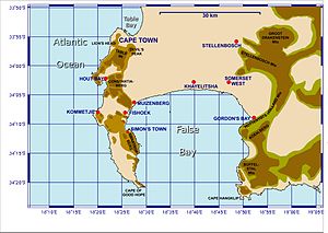
The park runs approximately north–south along the range of mountains that make up the mountainous spine of the Cape Peninsula, from Signal Hill in the north, through Lion's Head, Table Mountain, Constantiaberg, Silvermine, the mountains of the southern Peninsula, terminating at Cape Point.

The park is not a single contiguous area; the undeveloped mountainous areas which make up most of the park are separated by developed urban areas on the shallower terrain. Thus the park is divided into three separate sections, as listed below.

Table Mountain section

This section covers Signal Hill, Lion's Head, Table Mountain proper, including the Back Table (the rear, lower part of the mountain), Devil's Peak, the Twelve Apostles (actually a series of seventeen peaks along the Atlantic seaboard), and Orange Kloof (a specially protected area not open to the public). It borders on central Cape Town in the north, Camps Bay and the Atlantic coast in the west, the Southern Suburbs in the east, and Hout Bay in the south.

This section was formed from the Table Mountain National Monument, Cecilia Park, and Newlands Forest. Kirstenbosch National Botanical Garden is not officially part of the national park, but its higher reaches are maintained as part of the park.

Silvermine-Tokai section

This section runs northwest–southeast across the Peninsula from the Atlantic seaboard to the False Bay coast. It covers Constantiaberg, Steenberg Peak and the Kalk Bay mountains. It borders on Hout Bay in the north-west, the suburbs of Constantia and Tokai in the north-east, Kalk Bay in the south-east, and Fish Hoek and Noordhoek in the south-west.

This section was formed from the Tokai State Forest and the Silvermine Nature Reserve.

Cape Point section

Smitswinkel Bay, between Simon's Town and Cape Point.

This section covers the most southern area of the Cape Peninsula, stretching from Cape Point and the Cape of Good Hope in the south, as far north as Scarborough on the Atlantic coast and Simon's Town on the False Bay coast. It was formed from the Cape of Good Hope Nature Reserve.

Flora

A King Protea growing in Peninsula Sandstone Fynbos in Table Mountain National Park
Silver trees (Leucadendron argenteum) growing in Peninsula Granite Fynbos in Table Mountain National Park

This area forms part of the Cape Floristic Region and as such supports a high diversity of flora, much of which is rare and endemic. Protea, erica, restio and Asteraceae species, as well as geophytes, are all found in abundance. The main indigenous vegetation types are Peninsula Sandstone Fynbos and Cape Granite Fynbos, both of which are endangered and endemic to Cape Town - occurring nowhere else in the world.[2][3]

In addition, some sections of the park are the natural home of deep, indigenous Afro-temperate forests.

A well known local tree is the Silver tree (Leucadendron argenteum), a popularly cultivated species which is found in the wild only on the slopes of Lion's Head and a few scattered locations elsewhere on the Cape Peninsula (a notable area is above Kirstenbosch[4]).

The Park lies in the heart of the Cape Floral Kingdom, which is a bio-diversity hot spot and seen by botanists as a botanical anomaly.[5] In fact, there are more species of plants in Table Mountain National Park (over two thousand) than exist in the whole of the United Kingdom.[6] Much of the unique flora in the area surrounding the park has been lost to agriculture and urban development.

Indigenous plants are being increasingly harvested for traditional medicines, an activity some regard as a form of poaching. Such produce can be found on sale as remedies on the streets of Cape Town's central business district.[7] Indigenous species are also threatened by invasive plants such as Acacia cyclops, three Hakea species, and invasive pines that were planted in commercial timber plantations on the slopes of the mountain also . Today the Table Mountain range has the highest concentration of threatened species of any continental area of equivalent size in the world.[8]

Indigenous afro-montane forest on Table Mountain, with Devil's Peak visible in the distance
Commercial plantation of invasive European Pinus pinaster or "Cluster Pine", on Table Mountain's eastern slopes

Removal of non-indigenous forests

SANParks have been criticised for their programme of removing invasive non-indigenous trees. These alien forests make up only 2% of the park, but cover areas that were previously incredibly rich in biodiversity.

Some of the mature alien invasive trees that pose a threat to the fynbos region are Port Jackson, Rooikrans, Hakea, Pine and Blue Gum.[9]

The invasive trees were originally planted as commercial plantations for timber, once most of the indigenous afro-montane forests had been felled. Unfortunately, the fertile lower slopes that were selected for the plantations are also the areas of the park which host the highest proportion of endemic and threatened species.

The park's current programme is to allow for the re-growth of the indigenous forests, while slowly removing the plantations of invasive trees. This removal has been controversial however, as some of the pine plantations are recreational areas for people living in the wealthy suburbs adjacent to the park.[10][11]

Fauna

Male ostrich at Cape Good Hope

Larger predators that historically roamed the area include the Cape lion, leopard (which persisted as late as the 1920s, and tracks are claimed to still be found today[12]), as well as spotted hyena and black-backed jackal. Large herbivores similarly disappeared at the hands of the European settlers, for example elephant, black rhinoceros, kudu, eland, mountain zebra and bontebok, although the last three species were re-introduced to the Cape Point section of the park.[13]

Smaller mammals are still found in the park: caracal, rock hyrax and a variety of small antelope species, such as the Cape grysbok and notably the recently re-introduced klipspringer.

The population of the alien Himalayan tahr originated from a pair that escaped from the now defunct Zoological Gardens on Groot Schuur Estate below Devil's Peak in 1935. As of 2006, virtually all tahrs have been culled from Table Mountain, thus clearing the way for the re-introduction of the smaller klipspringer, with which the tahr would have competed due to similar niches.[14] However it is still highly likely that a few survived.

Chacma baboons inhabit the southern parts of the park. They are highly visible and popular with tourists, but are capable of becoming extremely dangerous when they become accustomed to human beings and start to associate them with free food. Many residents who live in places close to the park, such as Da Gama Park, Tokai and Scarborough, often clash with baboons which have attempted, and succeeded, in raiding their houses for food and many resort to measures such as reinforcing their security by erecting electric fences, and illegal measures like shooting them with pellet guns, running them over, and setting dogs on them.[15][16] This is ineffective as it can maim the baboons and simply reinforce their penchant for gaining easy food, as it is easier for baboons to raid a dustbin for scraps rather than forage in the mountains with only one hand.[17] Thus it is imperative that visitors to the park are not allowed to feed the baboons at all.

A rare endemic species of amphibian is only found on Table Mountain, the Table Mountain ghost frog. The Park lies in the heart of the Cape Floral Kingdom, which is a bio-diversity hot spot and seen by botanists as a botanical anomaly. In fact, there are more species of plant in Table Mountain National Park (over two thousand) than exist in the whole of the United Kingdom.[18]

Marine Protected Area

The Table Mountain National Park Marine Protected Area is an inshore marine protected area around the Cape Peninsula. It was proclaimed in Government Gazette No. 26431 of 4 June 2004 in terms of the Marine Living Resources Act, 18 of 1998.[19]

The MPA is of value for conservation of a wide range of endemic species, and has considerable economic value as a tourist destination. It encloses a large number of recreational dive sites visited by local residents and tourists from further afield. The shark and whale watching tourist industries are also represented, and there are several popular surf breaks. The MPA is mainly a controlled zone where extractive activities are allowed under permit, with six small no-take zones. The MPA is administrated by the Table Mountain National Park.

The marine ecology is unusually varied for an area of this size, as a result of the meeting of two major oceanic water masses near Cape Point, and the park extends into two coastal marine bioregions. The ecology of the west or "Atlantic Seaboard" side of the park is noticeably different in character and biodiversity to that of the east, or "False Bay" side. Both sides are classified as temperate waters, but there is a significant difference in average temperature, with the Atlantic side being noticeably colder on average.[20]

The MPA contains culturally significant fish traps, historical wrecks and traditional fishing communities, and is also important for commercial fisheries. Part of the West Coast rock lobster industry takes place within the MPA – as well as recreational and subsistence fishers, and an illegal poaching industry mostly targeting abalone, rock lobster and territorial linefish from the no-take zones.[20]

Tourist attractions

View over Cape Point; the lighthouse's white dome is just visible.

See also

References

  1. ^ Pooley, Simon (2014). Burning Table Mountain: an environmental history of the Cape Peninsula. London / Cape Town: Palgrave / UCT Press. pp. 135–161. ISBN 978-1-349-49059-2.
  2. ^ "Peninsula Sandstone Fynbos. Cape Town Biodiversity Factsheets" (PDF). Archived from the original (PDF) on 3 August 2017.
  3. ^ "Cape Granite Fynbos. Cape Town Biodiversity Factsheets" (PDF). Archived from the original (PDF) on 3 August 2017.
  4. ^ "Silver Tree". www.proteaatlas.org.za.
  5. ^ Manning, John (2007). Field Guide to Fynbos. ISBN 978-1-77007-265-7.
  6. ^ "Eight Things You Don't Know About Table Mountain". 20 June 2016.
  7. ^ "Rastafarian wild plant harvesters on Table Mountain". CAPE TREKKING. Archived from the original on 3 June 2016. Retrieved 8 April 2016.
  8. ^ Hannah, Lee; Midgley, Guy; Hughes, Greg; Bomhard, Bastian (March 2005). "The View from the Cape: Extinction Risk, Protected Areas, and Climate Change" (PDF). BioScience. 55 (3): 231–242. doi:10.1641/0006-3568(2005)055[0231:TVFTCE]2.0.CO;2. S2CID 14298619. Archived from the original (PDF) on 5 May 2012. Retrieved 6 August 2012.
  9. ^ "Alien Clearing - South African National Parks". www.sanparks.org. Retrieved 1 June 2022.
  10. ^ "Coolforests". Archived from the original on 16 May 2014. Retrieved 13 October 2006.
  11. ^ "No compromise on pines". Carte Blanche, M-Net. Archived from the original on 26 September 2006.
  12. ^ "Cape Town Table Mountain Fauna, dassie, or hyrax". Archived from the original on 7 August 2009. Retrieved 23 July 2009.
  13. ^ "South African National Parks - SANParks - Official Website - Accommodation, Activities, Prices, Reservations". www.sanparks.org.
  14. ^ "Table Mountain and the Himalayan Tahr". www.panda.org.za. Archived from the original on 10 September 2004. Retrieved 17 January 2022.
  15. ^ "Baboon "Gangs" Run Wild in Suburban South Africa". Archived from the original on 15 August 2009. Retrieved 24 July 2009.
  16. ^ Davids, Niemah (22 July 2009). "South Africa: Two Held for Pit-Bull Attack on Baboon" – via AllAfrica.
  17. ^ "Baboon Matters". www.baboonmatters.org.za. Archived from the original on 4 October 2006. Retrieved 6 June 2022.
  18. ^ "Visit Africa: Table Mountain National Park, South Africa". visitafrica.site. Retrieved 25 September 2020.
  19. ^ "Government Notice 695: Marine Living Resources Act (18/1998): Notice declaring the Table Mountain National Park Marine Protected Area under section 43" (PDF). Government Gazette: 3–9. 4 June 2004.
  20. ^ a b "Table Mountain National Park". MPA Forum South Africa. Retrieved 26 May 2018.
  • McNeely, Jeffrey A., 2001, "Globally significant biodiversity within city limits: the case of South Africa's Cape", Parks, vol. 11 no. 3, pp. 44–46. Retrieved on 18 January 2006.
  • 2000, South African National Map Series 1:50 000 Topographical Sheets 3318CD Cape Town and 3418AB&AD Cape Peninsula. Published by Chief Directorate: Surveys & Mapping.
  • Table Mountain National Park. Retrieved on 18 January 2006.
  • Cool Forests of Cape Town. Retrieved on 13 October 2006.
  • https://web.archive.org/web/20060926193042/http://www.carteblanche.co.za/display/Display.asp?Id=3165 No compromise on pines. Carte Blanche report on the loss of recreational non-indigenous forests. Retrieved on 14 October 2006.

External links

Wikivoyage has a travel guide for Table Mountain National Park.
Wikimedia Commons has media related to Table Mountain National Park.
  • official Table Mountain National Park−TMNP website
  • v
  • t
  • e
Table Mountain National Park
Mountain
ParkMiscellaneous
  • v
  • t
  • e
Natural environment
Bays
Beaches
Hills
Mountains
Islands
Headlands
Rivers and wetlands
Climate and weather
World heritage sites
Biodiversity
of Cape Town
Vegetation
types
Parks and
gardens
Nature reserves
Communities
Atlantic Seaboard
Blaauwberg
Cape Flats
(Klipfontein district)
Khayelitsha
Mitchells Plain
City Bowl
Helderberg
Northern Suburbs
Southern Suburbs
South Peninsula
Neighbourhoods
Built environment
Skyscrapers
Government
National government
Provincial government
City of Cape Town
Fortifications
Monuments and memorials
Lists of heritage sites
Historical buildings
Culture
Cuisine
Performance
art
Events and
festivals
Museums and
art galleries
Iziko Museums
Public art
Religion
Secular
architecture
Media
Companies based
in Cape Town
Hotels and resorts
Shopping areas,
malls and markets
Exhibition centres
Restaurants and cafés
Tourism
Air transport
Maritime transport
Road transport
Rail transport
Soccer
Rugby
Cricket
Other
Cape Town Tigers (basketball)
Sports events
Sports venues
Libraries
Universities
Colleges
Private
schools
Public schools
Alternative schools
Former schools
Art & Music schools
Not yet allocated
Services
Hospitals
Lighthouses
Western Cape
Water Supply System
Electrical power generation
Emergency services
Cape Town Outline
  • v
  • t
  • e
National taxon checklists
Plants
Flowering
plants
Animals
Arthropods
Arachnids
  • Harvestmen
  • Microwhip scorpions
  • Pseudoscorpions
  • Scorpions
  • Shorttailed whipscorpions
  • Solifugae
  • Araneae
  • Ixodida
  • Whip spiders and tailless whip scorpions
Insects
  • Alderflies, dobsonflies and fishflies
  • Beetles
  • Booklice, barklice and barkflies
  • Butterflies and moths
  • Caddisflies
  • Cockroaches and termites
  • Dragonflies and damselflies
  • Earwigs
  • Fleas
  • Flies
  • Jumping bristletails
  • Lice
  • Mantises
  • Mayflies
  • Net-winged insects
  • Notoptera
  • Orthoptera
  • Sawflies, wasps, bees, and ants
  • Scorpionflies
  • Silverfish and firebrats
  • Stick and leaf insects
  • Stoneflies
  • Strepsiptera
  • Termites
  • Thrips
  • True bugs
  • Webspinners
Molluscs
Vertebrates
Seaweeds
Fungi
Related
Regional taxon checklists and other minor lists
Tropical and subtropical
moist broadleaf forests
Tropical and subtropical grasslands,
savannas, and shrublands
Montane grasslands
and shrublands
Mediterranean forests,
woodlands, and scrub
Deserts and xeric shrublands
Tundra
Mangroves
Marine ecoregions
Savanna
  • Andesite Mountain Bushveld
  • Aoub Duneveld
  • Barberton Serpentine Sourveld
  • Bhisho Thornveld
  • Cathedral Mopane Bushveld
  • Central Sandy Bushveld
  • Delagoa Lowveld
  • Dwaalboom Thornveld
  • Dwarsberg-Swartruggens Mountain Bushveld
  • Eastern Valley Bushveld
  • Gabbro Grassy Bushveld
  • Gauteng Shale Mountain Bushveld
  • Ghaap Plateau Vaalbosveld
  • Gold Reef Mountain Bushveld
  • Gordonia Duneveld
  • Gordonia Kameeldoring Bushveld
  • Gordonia Plains Shrubland
  • Granite Lowveld
  • Gravelotte Rocky Bushveld
  • Kaalrug Mountain Bushveld
  • Kathu Bushveld
  • Kimberley Thornveld
  • Koranna-Langeberg Mountain Bushveld
  • Kuruman Mountain Bushveld
  • Kuruman Thornveld
  • Kuruman Vaalbosveld
  • KwaZulu-Natal Hinterland Thornveld
  • KwaZulu-Natal Sandstone Sourveld
  • Lebombo Summit Sourveld
  • Legogote Sour Bushveld
  • Limpopo Ridge Bushveld
  • Limpopo Sweet Bushveld
  • Loskop Mountain Bushveld
  • Loskop Thornveld
  • Lowveld Rugged Mopaneveld
  • Madikwe Dolomite Bushveld
  • Mafikeng Bushveld
  • Makatini Clay Thicket
  • Makhado Sweet Bushveld
  • Makuleke Sandy Bushveld
  • Malelane Mountain Bushveld
  • Mamabolo Mountain Bushveld
  • Marikana Thornveld
  • Molopo Bushveld
  • Moot Plains Bushveld
  • Mopane Basalt Shrubland
  • Mopane Gabbro Shrubland
  • Musina Mopane Bushveld
  • Ngongoni Veld
  • Norite Koppies Bushveld
  • Northern Lebombo Bushveld
  • Northern Zululand Sourveld
  • Nossob Bushveld
  • Nwambyia-Pumbe Sandy Bushveld
  • Ohrigstad Mountain Bushveld
  • Olifantshoek Plains Thornveld
  • Phalaborwa-Timbavati Mopaneveld
  • Pilanesberg Mountain Bushveld
  • Polokwane Plateau Bushveld
  • Postmasburg Thornveld
  • Poung Dolomite Mountain Bushveld
  • Pretoriuskop Sour Bushveld
  • Roodeberg Bushveld
  • Schmidtsdrif Thornveld
  • Schweizer-Reneke Bushveld
  • Sekhukhune Mountain Bushveld
  • Sekhukhune Plains Bushveld
  • South Eastern Coastal Thornveld
  • Southern Lebombo Bushveld
  • Soutpansberg Mountain Bushveld
  • Springbokvlakte Thornveld
  • Stella Bushveld
  • Swaziland Sour Bushveld
  • Tembe Sandy Bushveld
  • Thukela Thornveld
  • Thukela Valley Bushveld
  • Tsende Mopaneveld
  • Tshokwane-Hlane Basalt Lowveld
  • Tzaneen Sour Bushveld
  • Vaalbos Rocky Shrubland
  • VhaVenda Miombo
  • Waterberg Mountain Bushveld
  • Western Maputaland Clay Bushveld
  • Western Maputaland Sandy Bushveld
  • Western Sandy Bushveld
  • Zeerust Thornveld
  • Zululand Coastal Thornveld
  • Zululand Lowveld
Grassland
  • Aliwal North Dry Grassland
  • Amathole Mistbelt Grassland
  • Amathole Montane Grassland
  • Amersfoort Highveld Clay Grassland
  • Barberton Montane Grassland
  • Basotho Montane Shrubland
  • Bedford Dry Grassland
  • Besemkaree Koppies Shrubland
  • Bloemfontein Dry Grassland
  • Bloemfontein Karroid Shrubland
  • Carletonville Dolomite Grassland
  • Central Free State Grassland
  • Drakensberg Afroalpine Heathland
  • Drakensberg Foothill Moist Grassland
  • Drakensberg-Amathole Afromontane Fynbos
  • East Griqualand Grassland
  • Eastern Free State Clay Grassland
  • Eastern Free State Sandy Grassland
  • Eastern Highveld Grassland
  • Egoli Granite Grassland
  • Frankfort Highveld Grassland
  • Income Sandy Grassland
  • Ithala Quartzite Sourveld
  • KaNgwane Montane Grassland
  • Karoo Escarpment Grassland
  • Klerksdorp Thornveld
  • KwaZulu-Natal Highland Thornveld
  • Leolo Summit Sourveld
  • Lesotho Highland Basalt Grassland
  • Low Escarpment Moist Grassland
  • Lydenburg Montane Grassland
  • Lydenburg Thornveld
  • Mabela Sandy Grassland
  • Midlands Mistbelt Grassland
  • Mooi River Highland Grassland
  • Mthatha Moist Grassland
  • Northern Drakensberg Highland Grassland
  • Northern Escarpment Afromontane Fynbos
  • Northern Escarpment Dolomite Grassland
  • Northern Escarpment Quartzite Sourveld
  • Northern Free State Shrubland
  • Northern KwaZulu-Natal Moist Grassland
  • Northern KwaZulu-Natal Shrubland
  • Northern Zululand Mistbelt Grassland
  • Paulpietersburg Moist Grassland
  • Queenstown Thornveld
  • Rand Highveld Grassland
  • Sekhukhune Montane Grassland
  • Senqu Montane Shrubland
  • Southern Drakensberg Highland Grassland
  • Southern KwaZulu-Natal Moist Grassland
  • Soutpansberg Summit Sourveld
  • Soweto Highveld Grassland
  • Steenkampsberg Montane Grassland
  • Stormberg Plateau Grassland
  • Strydpoort Summit Sourveld
  • Tarkastad Montane Shrubland
  • Tsakane Clay Grassland
  • Tsomo Grassland
  • uKhahlamba Basalt Grassland
  • Vaal Reefs Dolomite Sinkhole Woodland
  • Vaal-Vet Sandy Grassland
  • Vredefort Dome Granite Grassland
  • Wakkerstroom Montane Grassland
  • Waterberg-Magaliesberg Summit Sourveld
  • Western Free State Clay Grassland
  • Western Highveld Sandy Grassland
  • Western Lesotho Basalt Shrubland
  • Winburg Grassy Shrubland
  • Wolkberg Dolomite Grassland
  • Woodbush Granite Grassland
  • Xhariep Karroid Grassland
  • Zastron Moist Grassland
Fynbos
  • Agulhas Limestone Fynbos
  • Agulhas Sand Fynbos
  • Albertinia Sand Fynbos
  • Algoa Sandstone Fynbos
  • Atlantis Sand Fynbos
  • Bokkeveld Sandstone Fynbos
  • Boland Granite Fynbos
  • Breede Alluvium Fynbos
  • Breede Quartzite Fynbos
  • Breede Sand Fynbos
  • Breede Shale Fynbos
  • Canca Limestone Fynbos
  • Cape Flats Sand Fynbos
  • Cape Winelands Shale Fynbos
  • Cederberg Sandstone Fynbos
  • Central Coastal Shale Band Vegetation
  • Central Inland Shale Band Vegetation
  • De Hoop Limestone Fynbos
  • Eastern Coastal Shale Band Vegetation
  • Eastern Inland Shale Band Vegetation
  • Elgin Shale Fynbos
  • Elim Ferricrete Fynbos
  • Garden Route Granite Fynbos
  • Garden Route Shale Fynbos
  • Graafwater Sandstone Fynbos
  • Greyton Shale Fynbos
  • Grootrivier Quartzite Fynbos
  • Hangklip Sand Fynbos
  • Hawequas Sandstone Fynbos
  • Hopefield Sand Fynbos
  • Kamiesberg Granite Fynbos
  • Kango Conglomerate Fynbos
  • Knysna Sand Fynbos
  • Kogelberg Sandstone Fynbos
  • Kouebokkeveld Alluvium Fynbos
  • Kouebokkeveld Shale Fynbos
  • Kouga Grassy Sandstone Fynbos
  • Kouga Sandstone Fynbos
  • Leipoldtville Sand Fynbos
  • Loerie Conglomerate Fynbos
  • Lourensford Alluvium Fynbos
  • Matjiesfontein Quartzite Fynbos
  • Matjiesfontein Shale Fynbos
  • Montagu Shale Fynbos
  • Namaqualand Sand Fynbos
  • North Hex Sandstone Fynbos
  • North Kammanassie Sandstone Fynbos
  • North Langeberg Sandstone Fynbos
  • North Outeniqua Sandstone Fynbos
  • North Rooiberg Sandstone Fynbos
  • North Sonderend Sandstone Fynbos
  • North Swartberg Sandstone Fynbos
  • Northern Inland Shale Band Vegetation
  • Olifants Sandstone Fynbos
  • Overberg Sandstone Fynbos
  • Peninsula Granite Fynbos
  • Peninsula Sandstone Fynbos
  • Piketberg Sandstone Fynbos
  • Potberg Ferricrete Fynbos
  • Potberg Sandstone Fynbos
  • Robertson Granite Fynbos
  • South Hex Sandstone Fynbos
  • South Kammanassie Sandstone Fynbos
  • South Langeberg Sandstone Fynbos
  • South Outeniqua Sandstone Fynbos
  • South Rooiberg Sandstone Fynbos
  • South Sonderend Sandstone Fynbos
  • South Swartberg Sandstone Fynbos
  • Southern Cape Dune Fynbos
  • Stinkfonteinberge Quartzite Fynbos
  • Suurberg Quartzite Fynbos
  • Suurberg Shale Fynbos
  • Swartberg Altimontane Sandstone Fynbos
  • Swartberg Shale Fynbos
  • Swartland Alluvium Fynbos
  • Swartruggens Quartzite Fynbos
  • Swellendam Silcrete Fynbos
  • Tsitsikamma Sandstone Fynbos
  • Western Altimontane Sandstone Fynbos
  • Western Coastal Shale Band Vegetation
  • Winterhoek Sandstone Fynbos
Renosterveld
  • Baviaanskloof Shale Renosterveld
  • Breede Alluvium Renosterveld
  • Breede Shale Renosterveld
  • Central Mountain Shale Renosterveld
  • Central Ruêns Shale Renosterveld
  • Ceres Shale Renosterveld
  • Eastern Ruêns Shale Renosterveld
  • Hantam Plateau Dolerite Renosterveld
  • Humansdorp Shale Renosterveld
  • Kango Limestone Renosterveld
  • Langkloof Shale Renosterveld
  • Matjiesfontein Shale Renosterveld
  • Montagu Shale Renosterveld
  • Mossel Bay Shale Renosterveld
  • Namaqualand Granite Renosterveld
  • Nieuwoudtville Shale Renosterveld
  • Nieuwoudtville-Roggeveld Dolerite Renosterveld
  • Peninsula Shale Renosterveld
  • Robertson Granite Renosterveld
  • Roggeveld Shale Renosterveld
  • Ruêns Silcrete Renosterveld
  • Swartberg Shale Renosterveld
  • Swartland Alluvium Renosterveld
  • Swartland Granite Renosterveld
  • Swartland Shale Renosterveld
  • Swartland Silcrete Renosterveld
  • Uniondale Shale Renosterveld
  • Vanrhynsdorp Shale Renosterveld
  • Western Ruêns Shale Renosterveld
Succulent
Karoo
  • Aggeneys Gravel Vygieveld
  • Agter-Sederberg Shrubland
  • Anenous Plateau Shrubland
  • Bushmanland Inselberg Shrubland
  • Central Knersvlakte Vygieveld
  • Central Richtersveld Mountain Shrubland
  • Citrusdal Vygieveld
  • Die Plate Succulent Shrubland
  • Doringrivier Quartzite Karoo
  • Eastern Little Karoo
  • Eenriet Plains Succulent Shrubland
  • Goariep Mountain Succulent Shrubland
  • Hantam Karoo
  • Kamiesberg Mountains Shrubland
  • Klawer Sandy Shrubland
  • Knersvlakte Dolomite Vygieveld
  • Knersvlakte Quartz Vygieveld
  • Knersvlakte Shale Vygieveld
  • Koedoesberge-Moordenaars Karoo
  • Kosiesberg Succulent Shrubland
  • Lekkersing Succulent Shrubland
  • Little Karoo Quartz Vygieveld
  • Namaqualand Arid Grassland
  • Namaqualand Blomveld
  • Namaqualand Coastal Duneveld
  • Namaqualand Heuweltjie Strandveld
  • Namaqualand Heuweltjieveld
  • Namaqualand Inland Duneveld
  • Namaqualand Klipkoppe Shrubland
  • Namaqualand Shale Shrubland
  • Namaqualand Spinescent Grassland
  • Namaqualand Strandveld
  • Northern Knersvlakte Vygieveld
  • Northern Richtersveld Scorpionstailveld
  • Northern Richtersveld Yellow Duneveld
  • Oograbies Plains Sandy Grassland
  • Piketberg Quartz Succulent Shrubland
  • Platbakkies Succulent Shrubland
  • Prince Albert Succulent Karoo
  • Richtersveld Coastal Duneveld
  • Richtersveld Red Duneveld
  • Richtersveld Sandy Coastal Scorpionstailveld
  • Riethuis-Wallekraal Quartz Vygieveld
  • Robertson Karoo
  • Roggeveld Karoo
  • Rooiberg Quartz Vygieveld
  • Rosyntjieberg Succulent Shrubland
  • Southern Namaqualand Quartzite Klipkoppe Shrubland
  • Southern Richtersveld Inselberg Shrubland
  • Southern Richtersveld Scorpionstailveld
  • Southern Richtersveld Yellow Duneveld
  • Steytlerville Karoo
  • Stinkfonteinberge Eastern Apron Shrubland
  • Swartruggens Quartzite Karoo
  • Tanqua Escarpment Shrubland
  • Tanqua Karoo
  • Tatasberg Mountain Succulent Shrubland
  • Umdaus Mountains Succulent Shrubland
  • Upper Annisvlakte Succulent Shrubland
  • Vanrhynsdorp Gannabosveld
  • Vyftienmyl se Berge Succulent Shrubland
  • Western Bushmanland Klipveld
  • Western Gwarrieveld
  • Western Little Karoo
  • Willowmore Gwarrieveld
Albany
Thicket
and
Strandveld
  • Albany Arid Thicket
  • Albany Bontveld
  • Albany Mesic Thicket
  • Albany Valley Thicket
  • Baviaans Valley Thicket
  • Bethelsdorp Bontveld
  • Blombos Strandveld
  • Buffels Mesic Thicket
  • Buffels Valley Thicket
  • Cape Flats Dune Strandveld
  • Crossroads Grassland Thicket
  • Doubledrift Karroid Thicket
  • Eastern Gwarrieveld
  • Elands Forest Thicket
  • Escarpment Arid Thicket
  • Escarpment Mesic Thicket
  • Escarpment Valley Thicket
  • Fish Arid Thicket
  • Fish Mesic Thicket
  • Fish Valley Thicket
  • Gamka Arid Thicket
  • Gamka Valley Thicket
  • Geluk Grassland Thicket
  • Goukamma Dune Thicket
  • Gouritz Valley Thicket
  • Grahamstown Grassland Thicket
  • Grassridge Bontveld
  • Groot Brak Dune Strandveld
  • Hamburg Dune Thicket
  • Hartenbos Dune Thicket
  • Kasouga Dune Thicket
  • Koedoeskloof Karroid Thicket
  • Lambert's Bay Strandveld
  • Langebaan Dune Strandveld
  • Mons Ruber Fynbos Thicket
  • Motherwell Karroid Thicket
  • Nanaga Savanna Thicket
  • Oudshoorn Karroid Thicket
  • Overberg Dune Strandveld
  • Saldanha Flats Strandveld
  • Saldanha Granite Strandveld
  • Saldanha Limestone Strandveld
  • Saltaire Karroid Thicket
  • Sardinia Forest Thicket
  • St Francis Dune Thicket
  • Subtropical Dune Thicket
  • Sundays Arid Thicket
  • Sundays Mesic Thicket
  • Sundays Valley Thicket
  • Thorndale Forest Thicket
  • Umtiza Forest Thicket
  • Vanstadens Forest Thicket
  • Western Gwarrieveld
  • Willowmore Gwarrieveld
Nama
Karoo
and
desert
  • Albany Broken Veld
  • Blouputs Karroid Thornveld
  • Bushmanland Arid Grassland
  • Bushmanland Basin Shrubland
  • Bushmanland Sandy Grassland
  • Eastern Lower Karoo
  • Eastern Upper Karoo
  • Gamka Karoo
  • Kalahari Karroid Shrubland
  • Lower Gariep Broken Veld
  • Lower Karoo Gwarrieveld
  • Northern Upper Karoo
  • Upper Karoo Hardeveld
  • Western Upper Karoo
  • Alexander Bay Coastal Duneveld
  • Eastern Gariep Plains Desert
  • Eastern Gariep Rocky Desert
  • Helskloof Canyon Desert
  • Kahams Mountain Desert
  • Kwaggarug Mountain Desert
  • Namib Lichen Fields
  • Noms Mountain Desert
  • Northern Nababiepsberge Mountain Desert
  • Richtersberg Mountain Desert
  • Richtersveld Sheet Wash Desert
  • Southern Nababiepsberge Mountain Desert
  • Western Gariep Hills Desert
  • Western Gariep Lowland Desert
  • Western Gariep Plains Desert
Azonal
  • Albany Alluvial Vegetation
  • Albany Dune Strandveld
  • Algoa Dune Strandveld
  • Arid Estuarine Salt Marshes
  • Bushmanland Vloere
  • Cape Estuarine Salt Marshes
  • Cape Inland Salt Pans
  • Cape Lowland Alluvial Vegetation
  • Cape Lowland Freshwater Wetlands
  • Cape Seashore Vegetation
  • Cape Vernal Pools
  • Drakensberg Wetlands
  • Eastern Temperate Freshwater Wetlands
  • Fynbos Riparian Vegetation
  • Highveld Alluvial Vegetation
  • Highveld Salt Pans
  • Lesotho Mires
  • Lower Gariep Alluvial Vegetation
  • Muscadel Riviere
  • Namaqualand Riviere
  • Namaqualand Salt Pans
  • Namaqualand Seashore Vegetation
  • Namib Seashore Vegetation
  • Southern Kalahari Mekgacha
  • Southern Kalahari Salt Pans
  • Southern Karoo Riviere
  • Subantarctic Kelp Bed Vegetation
  • Subtropical Alluvial Vegetation
  • Subtropical Dune Thicket
  • Subtropical Estuarine Salt Marshes
  • Subtropical Freshwater Wetlands
  • Subtropical Salt Pans
  • Subtropical Seashore Vegetation
  • Tanqua Wash Riviere
  • Upper Gariep Alluvial Vegetation
Forest
and
Coastal
belt
  • KwaZulu-Natal Coastal Belt
  • Maputaland Coastal Belt
  • Maputaland Wooded Grassland
  • Pondoland-Natal Sandstone Coastal Sourveld
  • Transkei Coastal Belt
  • Ironwood Dry Forest
  • Lowveld Riverine Forest
  • Mangrove Forest
  • Northern Afrotemperate Forest
  • Northern Coastal Forest
  • Northern Mistbelt Forest
  • Sand Forest
  • Scarp Forest
  • Southern Afrotemperate Forest
  • Southern Coastal Forest
  • Southern Mistbelt Forest
  • Swamp Forest
Subantarctic
biome
  • Subantarctic Biotic Herbfield and Grassland
  • Subantarctic Cinder Cone Vegetation
  • Subantarctic Coastal Vegetation
  • Subantarctic Drainage Line Vegetation
  • Subantarctic Fellfield
  • Subantarctic Fernbrake Vegetation
  • Subantarctic Mire
  • Subantarctic Polar Desert
not on
VEGMAP
South
African
National
Parks
Biosphere
reserves
Marine
protected
areas of
South
Africa
Coastal
Offshore
Management
organisations
Biodiversity research in SA
Research
organisations
Research
projects
Citizen science
databases
Botanical
gardens
Taxonomists
Regional biodiversity
Legislation
Publications
  • List of field guides to South African biota
  • Categories: Biodiversity of South Africa
  • Index
Authority control databases Edit this at Wikidata
International
  • VIAF
National
  • Germany
    • 2