Thornton, Lancashire
Human settlement in England
- Wyre
- Lancashire
- North West
- Wyre and Preston North
- List of places
- UK
- England
- Lancashire
Thornton is a village in the Borough of Wyre, about 4 miles (6 km) north of Blackpool and 2 miles (3 km) south of Fleetwood.[1] The civil parish of Thornton became an urban district in 1900, and was renamed Thornton-Cleveleys in 1927. In 2011 the Thornton built-up area sub division had a population of 18,941.[2]
History
Thornton is first mentioned in 1086 in the Domesday Book, where it was referred to as Torentum (a name preserved by Torentum Court on Lawsons Road). At the time it covered a large area including what are now Cleveleys and Fleetwood, and had a very low population density. It is thought that a settlement had existed at the site since the Iron Age, and a Roman road passes close to the village. The area remained lightly populated until 1799, when the marshland around the village was drained and agricultural production began on a large scale.[3]
Marsh Mill, a large well-preserved windmill, built in 1794, is a prominent landmark. It was commissioned by Bold Hesketh, uncle of Peter Hesketh (later Peter Hesketh-Fleetwood), who would go on to play a prominent role in the expansion of Fleetwood. Tragedy struck in May 1930, when a Miss Alice Baldwin and a Mrs Mary Jane Bailey visited the windmill with an interest in purchasing it. However, when both women stepped onto the fantail platform, the platform collapsed and the women fell to their deaths.[4]
A railway station was opened in Thornton in 1865. The opening of salt works at nearby Burn Naze by the United Alkali Company in the early 1890s (later becoming ICI) led to significant expansion of the village, with new houses and community buildings constructed. Thornton became an Urban District Council in 1900, surviving until 1974 when it became part of the Wyre Borough Council.[3]
A notable early building, The Illawalla, stood in Skippool between 1902 and 1996.
In 2015, the complete skeleton of a pre-historic wolf, nicknamed the Thornton Wolf, was discovered in the back garden of a home in the village.[5]
Transport
Rail

Thornton–Cleveleys railway station was formerly the principal intermediate stop on the Fleetwood branch of the LMS/British Rail London Midland Region railway, running from Poulton-le-Fylde, but it has been years since the station was used, and with the recent fencing-over of the level crossing in Station Road/Victoria Road East in order to prevent youths from congregating on the tracks, the glory days of Thornton are long since gone. However, a decision by an action group based in Poulton means they will finance a feasibility study into bringing the railway back to Thornton and Fleetwood.[6]
Bus
Thornton Centre's stops 1 and 2 are served by five bus routes:[citation needed]
- Blackpool Transport routes 74 and 75, which originate at Albert Square in Fleetwood and terminate at Preston bus station
- Transpora routes 24 and 660. The 24 originates in Fleetwood and terminates in Poulton-le-Fylde, while the weekday-only 660 originates in Cleveleys and terminates at Hodgson Academy in Poulton. The outbound journey arrives at Thornton Centre at 8.08 AM and the inbound return arrives at 3.07 PM
- Archway Travel route 525, which also runs only on weekdays, originates at Rossall Point in Fleetwood and terminates at Saint Aidan's Church of England High School in Preesall. The outbound journey departs Fleetwood at 7.20 AM and the inbound return departs at 3.10 PM
Amenities
Thornton's village shopping precinct opened in 1978.[7] It was replaced by a Co-op in the early 21st century.[8]
Thornton contains a number of schools, including Baines Endowed Primary School, Thornton Primary School, Stanah Primary School, Royles Brook Primary School, and Millfield Science & Performing Arts College in addition to a small public library.[9]
Gallery
-
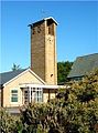
 Sacred Heart Roman Catholic Church
 -
 Christ Church, parish church
 -
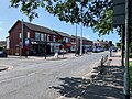 Shops on Victoria Road East in the village centre
 -
 County library, Four Lane Ends
 -
 Rows of cottages on Thornton's Underbank Road
 -
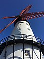 Marsh Mill


See also
References
- ^ "Distance from Thornton-Cleveleys to Blackpool". Retrieved 19 June 2015.
- ^ UK Census (2011). "Local Area Report – Thornton (Wyre) Built-up area sub division (E35000137)". Nomis. Office for National Statistics. Retrieved 27 March 2021.
- ^ a b History - Thornton Through Time Archived 2011-07-03 at the Wayback Machine
- ^ "BBC - Legacies - Architectural Heritage - England - Lancashire - Going through the mill - Article Page 3". www.bbc.co.uk. Retrieved 19 October 2018.
- ^ "'Ice Age' wolf bones found in Thornton Cleveleys garden". BBC News. 27 May 2015. Retrieved 16 September 2022.
- ^ "Boost for plans to reopen Poulton to Fleetwood rail link". Blackpool Gazette. 8 August 2007. Retrieved 18 September 2007.
- ^ "22 nostalgic scenes of Thornton which capture Victoria Road East, shops, precinct and surrounding streets in decades gone by" – Blackpool Gazette, 2 May 2023
- ^ "New-look Thornton-Cleveleys Co-op re-launches including partnership with Boyes who launch their latest value store inside". www.co-operative.coop. Retrieved 29 March 2024.
- ^ "Welcome to the Library and Information web site - Thornton Home Page". Lancashire County Council. Archived from the original on 13 June 2011. Retrieved 26 February 2008.
- v
- t
- e
Geography of the Borough of Wyre
- Bilsborrow
- Bleasdale
- Bonds
- Bowgreave
- Cabus
- Calder Vale
- Carleton
- Catterall
- Claughton
- Churchtown
- Dolphinholme
- Eagland Hill
- Forton
- Great Eccleston
- Hambleton
- Hollins Lane
- Inskip
- Knott End-on-Sea
- Myerscough
- Nateby
- Oakenclough
- Out Rawcliffe
- Pilling
- Rossall
- St Michael's on Wyre
- Scorton
- Scronkey
- Shireshead
- Stake Pool
- Stalmine
- Winmarleigh
| Hills | |
|---|---|
| Waterways | |
| Authority control databases: National |
|
|---|


