Wayah Bald

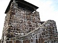
Wayah Bald is a high-altitude treeless open area in Nantahala National Forest, near Franklin, North Carolina. The Wayah Bald Observation Tower is located at the area's highest point (5,385 feet); the stone observation tower was built by the Civilian Conservation Corps in 1937 for fire detection.[1] The Appalachian Trail and Bartram Trail cross at Wayah Bald.
Wayah Bald is a popular destination for hikers,[2] especially during spring, when the rhododendron and azaleas are in bloom.
History
Wayah Bald received its name from the Cherokee natives. It was named "Waya", the Cherokee word for wolf, after the red wolves that once inhabited the area. Spear points found on the bald indicate that indigenous people used the area as hunting grounds more than eleven thousand years ago.[3]
Damage and repair
In 2009 and 2010, the Forest Service restored the north face of the tower using about $75,000. The tower's north wall was breaking down and the stones were removed and new concrete was used to repair the wall and reset the stones.[4][5]
In 2016, the tower was damaged by wildfires, leaving only the stone base. After this, it was temporarily closed to the public and reopened in 2018. Effort was made to restore the wooden top of the tower as accurately as possible.[5][6][7]
Photos
-
 Observation tower at the top of Wayah Bald, late December 2007
 -
 Trail markers where the Appalachian Trail and Bartram Trail meet
 -
 Rocks atop Wayah Bald, just after sunrise
 -
 View to the east just before sunrise
 -
 Sign for the Baltram Trail
 -
 Sunset over Wayah Bald


References
- ^ Sherpa Guides | North Carolina | Mountains | Wayah Bald Area
- ^ McCullough, Gary. "Southeast Excursions: A great view from Wayah up high". charlotteobserver. Retrieved 2019-06-28.
- ^ "Wayah Bald Visitors Information – Hot Springs, NC". www.blueridgeheritage.com. Archived from the original on 2007-02-06.
- ^ McRae, Barbara (31 July 2009). "Wayah Bald landmark to be restored". The Franklin Press. Retrieved 2009-08-16.
- ^ a b "Fire destroys Whitewater Falls area, Wayah Tower". Citizen Times. Retrieved 2019-06-28.
- ^ Hodge, Rex (2018-01-25). "Wayah Bald fire tower nears completion". WLOS. Retrieved 2019-06-28.
- ^ Hodge, Rex (2017-11-17). "Community rallies to rebuild fire-ravaged Wayah Bald tower". WLOS. Retrieved 2019-06-28.
35°10′49.7″N 83°33′38.75″W / 35.180472°N 83.5607639°W / 35.180472; -83.5607639
External links
 Media related to Wayah Bald at Wikimedia Commons
- v
- t
- e
| Bald Mountains |
|
|---|---|
| Black Mountains |
|
| Brushy Mountains |
|
| Great Balsam Mountains |
|
| Great Craggy Mountains | |
| Great Smoky Mountains | |
| Plott Balsams | |
| Unaka Range |
|
| Unicoi Mountains | |
| Iron Mountains |
|
| Others |
|
- Moore's Knob
- Pilot Mountain
- Albert Mountain
- Big Butt Mountain
- Cane Creek Mountains
- Crowders Mountain
- Devil's Courthouse
- Kings Pinnacle
- Looking Glass Rock
- Mayfield Mountain
- McAlpine Mountain
- Mount Jefferson
- Mulatto Mountain
- Occoneechee Mountain
- Old Butt Knob
- South Mountains
- Standing Indian Mountain
- Terrells Mountain
- Wayah Bald
- Wesser Bald
- Whiteside Mountain


