Paro (district)
Cet article concerne le district (dzongkhag) de Paro. Pour la ville de Paro, voir Paro (ville).
Cet article concerne le district (dzongkhag) de Paro. Pour le robot Paro, voir Paro (robot).

Cet article est une ébauche concernant le Bhoutan.
Vous pouvez partager vos connaissances en l’améliorant (comment ?) selon les recommandations des projets correspondants.
| Paro སྤ་རོ (spa-ro) | |
 | |
| Administration | |
|---|---|
| Pays |  Bhoutan Bhoutan |
| Type | Dzongkhag |
| Démographie | |
| Population | 65 000 hab. (2006) |
| Densité | 43 hab./km2 |
| Géographie | |
| Superficie | 1 502 km2 |
modifier  | |
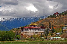
Paro est l'un des 20 dzongkhags (districts) du Bhoutan. Il est traversé par la Paro Chhu, un sous-affluent du Brahmapoutre.
Transports
L'aéroport international de Paro, situé à 2 235 m d'altitude, est l'unique aéroport du Bhoutan.
Villes du district

Cette section est vide, insuffisamment détaillée ou incomplète. Votre aide est la bienvenue ! Comment faire ?
- Atsho Chhubar
v · m Districts et sous-districts du Bhoutan | ||
|---|---|---|
| ||
| Districts (Dzongkhag) |
|  |
| Sous-districts (Dungkhag) |
| |
| ||
 Portail du Bhoutan


