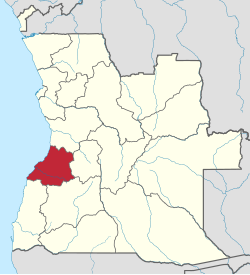
ベンゲラ州
ベンゲラ州 Benguela | |
|---|---|
 | |
 | |
| 国 |  アンゴラ アンゴラ |
| 州都 | ベンゲラ |
| 面積 | |
| • 合計 | 39,826 km2 |
| 人口 (2014年国勢調査)[1] | |
| • 合計 | 2,231,385人 |
| • 密度 | 56人/km2 |
| 等時帯 | UTC+1 (WAT) |
| ISO 3166コード | AO-BGU |
| HDI (2018) | 0.523[2] low · 12位 |
| ウェブサイト | www |
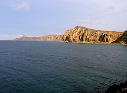
ベンゲラ州(ベンゲラしゅう、Benguela)は、アンゴラ共和国の州である。大西洋に面する。面積は39,250 km2、人口は約223万人(2014年)。州都はベンゲラ。
隣接州
ムニシピオ
ベンゲラ州は10の自治体(ムニシピオ)から成る[3]。
出身人物
「:Category:ベンゲラ州出身の人物」を参照
- ジョアン・ロウレンソ - 第3代アンゴラ大統領
脚注
- ^ “Resultados Definitivos Recenseamento Geral da População e Habitação – 2014 Província de Benguela”. Instituto Nacional de Estatística, República de Angola. 2020年5月3日閲覧。
- ^ “Sub-national HDI - Area Database - Global Data Lab” (英語). hdi.globaldatalab.org. 2020年2月27日閲覧。
- ^ “Censo 2014/BENGUELA”. アンゴラ統計局. 2021年4月28日閲覧。
外部リンク
- 公式サイト
- Information on this province at the Angolan ministry for territorial administration
- Province geographical info at geoview.info


