Greene County (Ohio)
County in de Verenigde Staten  | |||
|---|---|---|---|
 | |||
| Situering | |||
| Staat | Ohio | ||
| Tijdzone | Eastern Standard Time (UTC−5) | ||
| Coördinaten | 39°41'24"NB, 83°53'24"WL | ||
| Algemeen | |||
| Oppervlakte | 1.078 km² | ||
| - land | 1.075 km² | ||
| - water | 3 km² | ||
| Inwoners (2000) | 147.886 (138 inw./km²) | ||
| Overig | |||
| Zetel | Xenia | ||
| FIPS-code | 39057 | ||
| Opgericht | 1803 | ||
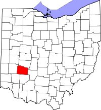
| Detailkaart | |||
 | |||
| Overzichtskaart van Greene County | |||
| Foto's | |||
 Bevolkingspiramide Greene County | |||
| Statistieken volkstelling Greene County | |||
| |||

Greene County is een van de 88 county's in de Amerikaanse staat Ohio.
De county heeft een landoppervlakte van 1.075 km² en telt 147.886 inwoners (volkstelling 2000). De hoofdplaats is Xenia.
Bevolkingsontwikkeling
| Jaar | Inwoners | % ± | |
|---|---|---|---|
| 1900 | 31.613 | — | |
| 1910 | 29.733 | −5,9% | |
| 1920 | 31.221 | 5,0% | |
| 1930 | 33.259 | 6,5% | |
| 1940 | 35.863 | 7,8% | |
| 1950 | 58.892 | 64,2% | |
| 1960 | 94.642 | 60,7% | |
| 1970 | 125.057 | 32,1% | |
| 1980 | 129.769 | 3,8% | |
| 1990 | 136.731 | 5,4% | |
| 2000 | 147.886 | 8,2% | |
| Bron: (en) Historical Decennial Census Population | |||

Adams County · Allen County · Ashland County · Ashtabula County · Athens County · Auglaize County · Belmont County · Brown County · Butler County · Carroll County · Champaign County · Clark County · Clermont County · Clinton County · Columbiana County · Coshocton County · Crawford County · Cuyahoga County · Darke County · Defiance County · Delaware County · Erie County · Fairfield County · Fayette County · Franklin County · Fulton County · Gallia County · Geauga County · Greene County · Guernsey County · Hamilton County · Hancock County · Hardin County · Harrison County · Henry County · Highland County · Hocking County · Holmes County · Huron County · Jackson County · Jefferson County · Knox County · Lake County · Lawrence County · Licking County · Logan County · Lorain County · Lucas County · Madison County · Mahoning County · Marion County · Medina County · Meigs County · Mercer County · Miami County · Monroe County · Montgomery County · Morgan County · Morrow County · Muskingum County · Noble County · Ottawa County · Paulding County · Perry County · Pickaway County · Pike County · Portage County · Preble County · Putnam County · Richland County · Ross County · Sandusky County · Scioto County · Seneca County · Shelby County · Stark County · Summit County · Trumbull County · Tuscarawas County · Union County · Van Wert County · Vinton County · Warren County · Washington County · Wayne County · Williams County · Wood County · Wyandot County


