Badonviller
Commune in Grand Est, France

Coat of arms
Location of Badonviller

(2020–2026) Bernard Muller[1]
1
(2021)[2]
54040 /54540
(avg. 404 m or 1,325 ft)
Badonviller (French pronunciation: [badɔ̃vile]; German: Badenweiler) is a commune in the Meurthe-et-Moselle department in northeastern France.
Geography
Climate
Badonviller has a oceanic climate (Köppen climate classification Cfb). The average annual temperature in Badonviller is 10.2 °C (50.4 °F). The average annual rainfall is 1,066.3 mm (41.98 in) with December as the wettest month. The temperatures are highest on average in July, at around 18.9 °C (66.0 °F), and lowest in January, at around 1.9 °C (35.4 °F). The highest temperature ever recorded in Badonviller was 39.1 °C (102.4 °F) on 4 August 2022; the coldest temperature ever recorded was −22.0 °C (−7.6 °F) on 14 January 1960.
| Climate data for Badonviller (1991−2020 normals, extremes 1959−present) | |||||||||||||
|---|---|---|---|---|---|---|---|---|---|---|---|---|---|
| Month | Jan | Feb | Mar | Apr | May | Jun | Jul | Aug | Sep | Oct | Nov | Dec | Year |
| Record high °C (°F) | 18.5 (65.3) | 22.0 (71.6) | 26.3 (79.3) | 29.5 (85.1) | 33.5 (92.3) | 36.4 (97.5) | 38.9 (102.0) | 39.1 (102.4) | 33.0 (91.4) | 27.8 (82.0) | 24.0 (75.2) | 21.0 (69.8) | 39.1 (102.4) |
| Mean daily maximum °C (°F) | 5.1 (41.2) | 6.7 (44.1) | 11.1 (52.0) | 15.7 (60.3) | 19.6 (67.3) | 23.2 (73.8) | 25.3 (77.5) | 25.0 (77.0) | 20.6 (69.1) | 15.5 (59.9) | 9.3 (48.7) | 5.8 (42.4) | 15.2 (59.4) |
| Daily mean °C (°F) | 1.9 (35.4) | 2.7 (36.9) | 5.9 (42.6) | 9.4 (48.9) | 13.5 (56.3) | 16.9 (62.4) | 18.9 (66.0) | 18.7 (65.7) | 14.7 (58.5) | 10.8 (51.4) | 5.8 (42.4) | 2.8 (37.0) | 10.2 (50.4) |
| Mean daily minimum °C (°F) | −1.3 (29.7) | −1.3 (29.7) | 0.8 (33.4) | 3.2 (37.8) | 7.4 (45.3) | 10.7 (51.3) | 12.6 (54.7) | 12.3 (54.1) | 8.9 (48.0) | 6.0 (42.8) | 2.2 (36.0) | −0.1 (31.8) | 5.1 (41.2) |
| Record low °C (°F) | −22.0 (−7.6) | −20.0 (−4.0) | −18.5 (−1.3) | −9.5 (14.9) | −4.0 (24.8) | −1.0 (30.2) | 2.0 (35.6) | 2.0 (35.6) | −2.5 (27.5) | −7.0 (19.4) | −13.0 (8.6) | −19.0 (−2.2) | −22.0 (−7.6) |
| Average precipitation mm (inches) | 90.1 (3.55) | 80.7 (3.18) | 81.1 (3.19) | 68.4 (2.69) | 96.5 (3.80) | 85.7 (3.37) | 93.0 (3.66) | 84.2 (3.31) | 91.1 (3.59) | 94.4 (3.72) | 96.8 (3.81) | 104.3 (4.11) | 1,066.3 (41.98) |
| Average precipitation days (≥ 1.0 mm) | 14.6 | 12.8 | 11.9 | 10.8 | 12.7 | 11.2 | 11.4 | 10.9 | 10.8 | 12.8 | 13.9 | 15.2 | 148.8 |
| Source: Météo-France[3] | |||||||||||||
Population
| Year | Pop. | ±% p.a. |
|---|---|---|
| 1968 | 2,050 | — |
| 1975 | 1,920 | −0.93% |
| 1982 | 1,812 | −0.82% |
| 1990 | 1,660 | −1.09% |
| 1999 | 1,512 | −1.03% |
| 2009 | 1,617 | +0.67% |
| 2014 | 1,566 | −0.64% |
| 2020 | 1,559 | −0.07% |
| Source: INSEE[4] | ||
-
 Monument of the 358th Infantry Regiment
 -
 Military cemetery
 -
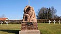 Statue carved February 15, 1916
 -
 French flag in the military cemetery
 -
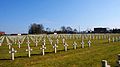 Crosses in the military cemetery
 -
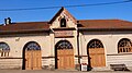 Covered market


Personalities
It is the birth town of the astronomer Charles Messier (1730–1817).
See also
- Communes of the Meurthe-et-Moselle department
- Badonviller March
- Badenweiler, Germany
- Antoine Sartorio
References
- ^ "Répertoire national des élus: les maires". data.gouv.fr, Plateforme ouverte des données publiques françaises (in French). 2 December 2020.
- ^ "Populations légales 2021". The National Institute of Statistics and Economic Studies. 28 December 2023.
- ^ "Fiche Climatologique Statistiques 1991-2020 et records" (PDF). Météo-France. Retrieved 23 August 2022.
- ^ Population en historique depuis 1968, INSEE
Wikimedia Commons has media related to Badonviller.
- v
- t
- e

- Abaucourt
- Abbéville-lès-Conflans
- Aboncourt
- Affléville
- Affracourt
- Agincourt
- Aingeray
- Allain
- Allamont
- Allamps
- Allondrelle-la-Malmaison
- Amance
- Amenoncourt
- Ancerviller
- Anderny
- Andilly
- Angomont
- Anoux
- Ansauville
- Anthelupt
- Armaucourt
- Arnaville
- Arracourt
- Arraye-et-Han
- Art-sur-Meurthe
- Athienville
- Atton
- Auboué
- Audun-le-Roman
- Autrepierre
- Autreville-sur-Moselle
- Autrey
- Avillers
- Avrainville
- Avricourt
- Avril
- Azelot
- Azerailles
- Baccarat
- Badonviller
- Bagneux
- Bainville-aux-Miroirs
- Bainville-sur-Madon
- Barbas
- Barbonville
- Barisey-au-Plain
- Barisey-la-Côte
- Les Baroches
- Baslieux
- Bathelémont
- Batilly
- Battigny
- Bauzemont
- Bayon
- Bayonville-sur-Mad
- Bazailles
- Beaumont
- Béchamps
- Belleau
- Belleville
- Bénaménil
- Benney
- Bernécourt
- Bertrambois
- Bertrichamps
- Bettainvillers
- Beuveille
- Beuvezin
- Beuvillers
- Bey-sur-Seille
- Bezange-la-Grande
- Bezaumont
- Bicqueley
- Bienville-la-Petite
- Bionville
- Blainville-sur-l'Eau
- Blâmont
- Blémerey
- Blénod-lès-Pont-à-Mousson
- Blénod-lès-Toul
- Bois-de-Haye
- Boismont
- Boncourt
- Bonviller
- Borville
- Boucq
- Bouillonville
- Bouvron
- Bouxières-aux-Chênes
- Bouxières-aux-Dames
- Bouxières-sous-Froidmont
- Bouzanville
- Brainville
- Bralleville
- Bratte
- Bréhain-la-Ville
- Bréménil
- Brémoncourt
- Brin-sur-Seille
- Brouville
- Bruley
- Bruville
- Buissoncourt
- Bulligny
- Bures
- Buriville
- Burthecourt-aux-Chênes
- Ceintrey
- Cerville
- Chaligny
- Chambley-Bussières
- Champenoux
- Champey-sur-Moselle
- Champigneulles
- Chanteheux
- Chaouilley
- Charency-Vezin
- Charey
- Charmes-la-Côte
- Charmois
- Chaudeney-sur-Moselle
- Chavigny
- Chazelles-sur-Albe
- Chenevières
- Chenicourt
- Chenières
- Choloy-Ménillot
- Cirey-sur-Vezouze
- Clayeures
- Clémery
- Clérey-sur-Brenon
- Coincourt
- Colmey
- Colombey-les-Belles
- Conflans-en-Jarnisy
- Cons-la-Grandville
- Cosnes-et-Romain
- Courbesseaux
- Courcelles
- Coyviller
- Crantenoy
- Crépey
- Crévéchamps
- Crévic
- Crézilles
- Crion
- Croismare
- Crusnes
- Custines
- Cutry
- Damelevières
- Dampvitoux
- Deneuvre
- Deuxville
- Diarville
- Dieulouard
- Dolcourt
- Dombasle-sur-Meurthe
- Domèvre-en-Haye
- Domèvre-sur-Vezouze
- Domgermain
- Domjevin
- Dommarie-Eulmont
- Dommartemont
- Dommartin-la-Chaussée
- Dommartin-lès-Toul
- Dommartin-sous-Amance
- Domprix
- Domptail-en-l'Air
- Doncourt-lès-Conflans
- Doncourt-lès-Longuyon
- Drouville
- Écrouves
- Einvaux
- Einville-au-Jard
- Emberménil
- Épiez-sur-Chiers
- Éply
- Erbéviller-sur-Amezule
- Errouville
- Essey-et-Maizerais
- Essey-la-Côte
- Essey-lès-Nancy
- Étreval
- Eulmont
- Euvezin
- Faulx
- Favières
- Fécocourt
- Fenneviller
- Ferrières
- Fey-en-Haye
- Fillières
- Flainval
- Flavigny-sur-Moselle
- Fléville-devant-Nancy
- Fléville-Lixières
- Flin
- Flirey
- Fontenoy-la-Joûte
- Fontenoy-sur-Moselle
- Forcelles-Saint-Gorgon
- Forcelles-sous-Gugney
- Foug
- Fraimbois
- Fraisnes-en-Saintois
- Francheville
- Franconville
- Fréménil
- Frémonville
- Fresnois-la-Montagne
- Friauville
- Frolois
- Frouard
- Froville
- Gélacourt
- Gélaucourt
- Gellenoncourt
- Gémonville
- Gerbécourt-et-Haplemont
- Gerbéviller
- Germiny
- Germonville
- Gézoncourt
- Gibeaumeix
- Giraumont
- Giriviller
- Glonville
- Gogney
- Gondrecourt-Aix
- Gondreville
- Gondrexon
- Gorcy
- Goviller
- Grand-Failly
- Grimonviller
- Gripport
- Griscourt
- Grosrouvres
- Gugney
- Gye
- Hablainville
- Hagéville
- Haigneville
- Halloville
- Hammeville
- Hamonville
- Han-devant-Pierrepont
- Hannonville-Suzémont
- Haraucourt
- Harbouey
- Haroué
- Hatrize
- Haucourt-Moulaine
- Haudonville
- Haussonville
- Heillecourt
- Hénaménil
- Herbéviller
- Hériménil
- Herserange
- Hoéville
- Homécourt
- Houdelmont
- Houdemont
- Houdreville
- Housséville
- Hudiviller
- Hussigny-Godbrange
- Igney
- Jaillon
- Jarny
- Jarville-la-Malgrange
- Jaulny
- Jeandelaincourt
- Jeandelize
- Jevoncourt
- Jezainville
- Jœuf
- Jolivet
- Joppécourt
- Jouaville
- Joudreville
- Juvrecourt
- Labry
- Lachapelle
- Lagney
- Laître-sous-Amance
- Laix
- Lalœuf
- Lamath
- Landécourt
- Landremont
- Landres
- Laneuvelotte
- Laneuveville-aux-Bois
- Laneuveville-derrière-Foug
- Laneuveville-devant-Bayon
- Laneuveville-devant-Nancy
- Lanfroicourt
- Lantéfontaine
- Laronxe
- Laxou
- Lay-Saint-Christophe
- Lay-Saint-Remy
- Lebeuville
- Leintrey
- Lemainville
- Leménil-Mitry
- Lenoncourt
- Lesménils
- Létricourt
- Lexy
- Leyr
- Limey-Remenauville
- Lironville
- Liverdun
- Loisy
- Longlaville
- Longuyon
- Longwy
- Lorey
- Loromontzey
- Lubey
- Lucey
- Ludres
- Lunévillesubpr
- Lupcourt
- Magnières
- Maidières
- Mailly-sur-Seille
- Mairy-Mainville
- Maixe
- Maizières
- Malavillers
- Malleloy
- Malzéville
- Mamey
- Mandres-aux-Quatre-Tours
- Mangonville
- Manoncourt-en-Vermois
- Manoncourt-en-Woëvre
- Manonville
- Manonviller
- Marainviller
- Marbache
- Maron
- Mars-la-Tour
- Marthemont
- Martincourt
- Mattexey
- Maxéville
- Mazerulles
- Méhoncourt
- Ménil-la-Tour
- Mercy-le-Bas
- Mercy-le-Haut
- Méréville
- Merviller
- Messein
- Mexy
- Mignéville
- Millery
- Minorville
- Moineville
- Moivrons
- Moncel-lès-Lunéville
- Moncel-sur-Seille
- Mont-Bonvillers
- Montauville
- Montenoy
- Montigny
- Montigny-sur-Chiers
- Mont-l'Étroit
- Mont-le-Vignoble
- Montreux
- Mont-Saint-Martin
- Mont-sur-Meurthe
- Morfontaine
- Moriviller
- Morville-sur-Seille
- Mouacourt
- Mouaville
- Mousson
- Moutiers
- Moutrot
- Moyen
- Murville
- Nancypref
- Neufmaisons
- Neuves-Maisons
- Neuviller-lès-Badonviller
- Neuviller-sur-Moselle
- Nomeny
- Nonhigny
- Norroy-le-Sec
- Norroy-lès-Pont-à-Mousson
- Noviant-aux-Prés
- Ochey
- Ogéviller
- Ognéville
- Olley
- Omelmont
- Onville
- Ormes-et-Ville
- Othe
- Ozerailles
- Pagney-derrière-Barine
- Pagny-sur-Moselle
- Pannes
- Parey-Saint-Césaire
- Parroy
- Parux
- Petit-Failly
- Petitmont
- Pettonville
- Pexonne
- Phlin
- Piennes
- Pierre-la-Treiche
- Pierre-Percée
- Pierrepont
- Pierreville
- Pompey
- Pont-à-Mousson
- Pont-Saint-Vincent
- Port-sur-Seille
- Praye
- Prény
- Preutin-Higny
- Pulligny
- Pulney
- Pulnoy
- Puxe
- Puxieux
- Quevilloncourt
- Raon-lès-Leau
- Raucourt
- Raville-sur-Sânon
- Réchicourt-la-Petite
- Réclonville
- Rehainviller
- Reherrey
- Réhon
- Reillon
- Rembercourt-sur-Mad
- Remenoville
- Réméréville
- Remoncourt
- Repaix
- Richardménil
- Rogéville
- Romain
- Rosières-aux-Salines
- Rosières-en-Haye
- Rouves
- Roville-devant-Bayon
- Royaumeix
- Rozelieures
- Saffais
- Saint-Ail
- Saint-Baussant
- Saint-Boingt
- Saint-Clément
- Sainte-Geneviève
- Sainte-Pôle
- Saint-Firmin
- Saint-Germain
- Saint-Jean-lès-Longuyon
- Saint-Julien-lès-Gorze
- Saint-Marcel
- Saint-Mard
- Saint-Martin
- Saint-Maurice-aux-Forges
- Saint-Max
- Saint-Nicolas-de-Port
- Saint-Pancré
- Saint-Remimont
- Saint-Rémy-aux-Bois
- Saint-Sauveur
- Saint-Supplet
- Saizerais
- Sancy
- Sanzey
- Saulnes
- Saulxerotte
- Saulxures-lès-Nancy
- Saulxures-lès-Vannes
- Saxon-Sion
- Seichamps
- Seicheprey
- Selaincourt
- Seranville
- Serres
- Serrouville
- Sexey-aux-Forges
- Sionviller
- Sivry
- Sommerviller
- Sornéville
- Sponville
- Tanconville
- Tantonville
- Tellancourt
- Thélod
- They-sous-Vaudemont
- Thézey-Saint-Martin
- Thiaucourt-Regniéville
- Thiaville-sur-Meurthe
- Thiébauménil
- Thil
- Thorey-Lyautey
- Thuilley-aux-Groseilles
- Thumeréville
- Tiercelet
- Tomblaine
- Tonnoy
- Toulsubpr
- Tramont-Émy
- Tramont-Lassus
- Tramont-Saint-André
- Tremblecourt
- Trieux
- Trondes
- Tronville
- Tucquegnieux
- Ugny
- Uruffe
- Vacqueville
- Val de Brieysubpr
- Val-et-Châtillon
- Valhey
- Valleroy
- Vallois
- Vandelainville
- Vandeléville
- Vandières
- Vandœuvre-lès-Nancy
- Vannes-le-Châtel
- Varangéville
- Vathiménil
- Vaucourt
- Vaudémont
- Vaudeville
- Vaudigny
- Vaxainville
- Vého
- Velaine-sous-Amance
- Velle-sur-Moselle
- Veney
- Vennezey
- Verdenal
- Vézelise
- Viéville-en-Haye
- Vigneulles
- Vilcey-sur-Trey
- Villacourt
- Ville-au-Montois
- Ville-au-Val
- Villecey-sur-Mad
- Ville-en-Vermois
- Ville-Houdlémont
- Villers-en-Haye
- Villers-la-Chèvre
- Villers-la-Montagne
- Villers-le-Rond
- Villers-lès-Moivrons
- Villers-lès-Nancy
- Villers-sous-Prény
- Villerupt
- Ville-sur-Yron
- Villette
- Villey-le-Sec
- Villey-Saint-Étienne
- Virecourt
- Viterne
- Vitrey
- Vitrimont
- Vittonville
- Viviers-sur-Chiers
- Voinémont
- Vroncourt
- Waville
- Xammes
- Xermaménil
- Xeuilley
- Xirocourt
- Xivry-Circourt
- Xonville
- Xousse
- Xures
- pref: prefecture
- subpr: subprefecture
Authority control databases | |
|---|---|
| International |
|
| National |
|
| Other |
|
 | This Meurthe-et-Moselle geographical article is a stub. You can help Wikipedia by expanding it. |
- v
- t
- e


