Bushy Park, Victoria
Town in Victoria, Australia
37°52′S 147°01′E / 37.867°S 147.017°E / -37.867; 147.017Bushy Park is a town in Victoria, Australia, located on Briagolong Road, north of Maffra, in the Shire of Wellington.
Bushy Park Post Office opened on 1 November 1889 and closed in 1938.[2]
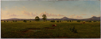

Eugene von Guerard View of the Gippsland Alps, from Bushy Park on the River Avon (1861)
References
- ^ Australian Bureau of Statistics (27 June 2017). "Bushy Park (State Suburb)". 2016 Census QuickStats. Retrieved 20 August 2020.

- ^ Phoenix Auctions History, Post Office List, retrieved 23 March 2021
- v
- t
- e
Localities in the Shire of Wellington
- Sale

- Alberton
- Boisdale
- Briagolong
- Bundalaguah
- Cobains
- Coongulla
- Cowwarr^
- Denison
- Devon North
- East Sale
- Fulham
- Glengarry^
- Glenmaggie
- Golden Beach
- Gormandale
- Heyfield
- Loch Sport
- Longford
- Maffra
- Nambrok
- Newry
- Port Albert
- Rosedale
- Seaspray
- Stratford
- Tinamba
- Toongabbie^
- Woodside
- Wurruk
- Yarram
- Airly
- Alberton West
- Arbuckle
- Balook^
- Billabong
- Binginwarri^
- Blackwarry
- Budgee Budgee
- Buragwonduc
- Bushy Park
- Callignee North
- Callignee South
- Calrossie
- Carrajung
- Carrajung Lower
- Carrajung South
- Clydebank
- Cowa
- Crookayan
- Crooked River
- Dargo^
- Darriman
- Dawson
- Dutson
- Dutson Downs
- Fernbank^
- Flamingo Beach
- Flynn^
- Flynns Creek^
- Gelliondale
- Giffard
- Giffard West
- Gillum
- Glenfalloch
- Glomar Beach
- Grand Ridge^
- Hawkhurst
- Hedley^
- Hiamdale
- Hiawatha
- Hollands Landing
- Howitt Plains
- Hunterston
- Jack River
- Kilmany
- Koorool
- Lake Wellington
- Langsborough
- Licola
- Licola North
- Llowalong
- Macks Creek
- Madalya
- Maffra West Upper
- Manns Beach
- McLoughlins Beach
- Meerlieu
- Miowera
- Monomak
- Montgomery
- Moornapa
- Moroka
- Munro
- Myrtlebank
- Nap Nap Marra
- Ocean Grange^
- Paradise Beach
- Pearsondale
- Perry Bridge
- Reynard^
- Riverslea
- Robertsons Beach
- Sargood
- Seacombe
- Seaton
- Snake Island
- Staceys Bridge
- Stockdale
- Stradbroke
- Tamboritha
- Tarra Valley
- Tarraville
- The Heart
- The Honeysuckles
- Tinamba West
- Toolome
- Valencia Creek
- Walhalla^
- Walhalla East
- Willung
- Willung South
- Winnindoo
- Won Wron
- Wongungarra^
- Wonyip
- Woodside Beach
- Woodside North
- Woolenook
- Worrowing
- Wrathung
- Wrixon
- Yangoura
^ - Territory divided with another LGA
 | This article about a location in Gippsland (region) is a stub. You can help Wikipedia by expanding it. |
- v
- t
- e


