Mount Airy, New Jersey
Populated place in Hunterdon County, New Jersey, US
Unincorporated community in New Jersey, United States
40°23′55″N 74°54′26″W / 40.39861°N 74.90722°W / 40.39861; -74.90722 United States
 New Jersey
Mount Airy is an unincorporated community located within West Amwell Township in Hunterdon County, in the U.S. state of New Jersey.[2]
History
A mill existed on the Alexauken Creek east of Mount Airy prior to the Revolution. By 1881, Mount Airy had a school, store, church, wagon and blacksmith shop, grist-mill, and about 12 dwellings. Prior to 1881 a hotel was located at the settlement.[3]
Historic district
United States historic place
Mount Airy Historic District | |
| Area | 105 acres (42 ha) |
|---|---|
| NRHP reference No. | 89001943[4] |
| NJRHP No. | 1641[5] |
| Significant dates | |
| Added to NRHP | November 13, 1989 |
| Designated NJRHP | September 14, 1989 |
The Mount Airy Historic District is a 105-acre (42 ha) historic district encompassing the community. It was added to the National Register of Historic Places on November 13, 1989, for its significance in architecture, commerce, industry, and settlement.[4] The district includes 26 contributing buildings, and two contributing sites. The Old Mount Airy Tavern was built in the late 18th century and was a stage coach stop on the Old York Road. Holcombe's Storehouse is a late 18th century two and one-half story coursed rubble stone building with overhanging hoist. Both have been converted into residences.[6] The Gothic Revival style Second English Presbyterian Church of Amwell, also known as the Mount Airy Presbyterian Church, was built in 1874. The church was founded in 1754. The cemetery was started in the mid 18th century.[6]
-
 Holcombe's Storehouse
 -
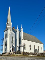 Mount Airy Presbyterian Church
 -
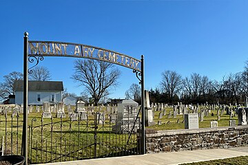 Mount Airy Cemetery
 -
 Cemetery information sign


References
- ^ a b "Mount Airy". Geographic Names Information System. United States Geological Survey, United States Department of the Interior.
- ^ Locality Search, State of New Jersey. Accessed January 31, 2015.
- ^ Snell, James P. (1881). History of Hunterdon and Somerset Counties, New Jersey. Everts & Peck. pp. 346, 349.
- ^ a b "National Register Information System – (#89001943)". National Register of Historic Places. National Park Service. November 2, 2013.
- ^ "New Jersey and National Registers of Historic Places – Hunterdon County" (PDF). New Jersey Department of Environmental Protection – Historic Preservation Office. September 11, 2023. p. 18.
- ^ a b Bertland, Dennis (November 1988). "National Register of Historic Places Inventory/Nomination: Mount Airy Historic District". National Park Service. With accompanying 27 photos
External links
 Media related to Mount Airy, New Jersey at Wikimedia Commons
- v
- t
- e
Municipalities and communities of Hunterdon County, New Jersey, United States
County seat: Flemington

communities
- Allerton
- Amsterdam
- Anthony
- Baptistown
- Barbertown
- Barley Sheaf
- Bowne
- Bunnvale
- Byram
- Centerville
- Charlestown
- Cherryville
- Cloverhill
- Cokesbury
- Copper Hill
- Darts Mills
- Dreahook
- Everittstown
- Fairmount
- Grandin
- Hamden
- Headquarters
- Hoffmans
- Hughesville
- Jutland
- Lansdowne
- Larisons Corners
- Linvale
- Little York
- Lower Valley
- Mechanicsville
- Mount Airy
- Mount Pleasant
- Mountainville
- New Hampton
- Norton
- Pattenburg
- Penwell
- Perryville
- Pittstown
- Pleasant Run
- Potterstown
- Prallsville
- Quakertown
- Raven Rock
- Readingsburg
- Readington Village
- Reaville
- Rockefellows Mills
- Rosemont
- Rowland's Mills
- Sand Brook
- Sandy Ridge
- Sergeantsville
- Snydertown
- Spruce Run
- Stanton
- Tumble Falls
- Vanlieu Corners
- Van Syckel
- Wertsville
- West Portal
- Whitehouse
‡This populated place also has portions in an adjacent county or counties
- New Jersey portal
- United States portal
| ||
|---|---|---|
| Topics |  | |
| Lists by county | ||
| Other lists | ||
| ||


