Mount Pleasant, Hunterdon County, New Jersey
Populated place in Hunterdon County, New Jersey, US
Unincorporated community in New Jersey, United States
40°34′48″N 75°3′0″W / 40.58000°N 75.05000°W / 40.58000; -75.05000 United States
 New Jersey
Mount Pleasant is an unincorporated community located along County Route 519 on the border of Alexandria Township and Holland Township, in Hunterdon County, New Jersey.[1][2][3] The Mount Pleasant Historic District was listed on the National Register of Historic Places in 1987.
History
The Presbyterian church was organized c. 1752 and worshipped in a log meeting house. The Mount Pleasant school was started before 1790. By the 1880s, the community had a post office, two stores, a mill, a blacksmith and a tavern.[4]
Historic district
United States historic place
Mount Pleasant Historic District | |
 Mount Pleasant General Store | |
| Location | County Route 519 and Rick Road |
|---|---|
| Area | 59 acres (24 ha) |
| Built | 1800 (1800) |
| Architectural style | Greek Revival, Late Victorian, Federal |
| NRHP reference No. | 87002012[5] |
| NJRHP No. | 1561[6] |
| Significant dates | |
| Added to NRHP | November 16, 1987 |
| Designated NJRHP | October 5, 1987 |
The Mount Pleasant Historic District is a 59-acre (24 ha) historic district encompassing the community along County Route 519 (Little York–Mount Pleasant Road) and Rick Road. It was added to the National Register of Historic Places on November 16, 1987 for its significance in agriculture, architecture, commerce, settlement, and industry. It includes 34 contributing buildings.[3]
The Presbyterian Church, built in 1843, and the general store, built in the 1860s, feature vernacular Greek Revival style.[3]
-
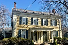 Vernacular Greek Revival house

See also
References
- ^ a b c "Mount Pleasant". Geographic Names Information System. United States Geological Survey, United States Department of the Interior.
- ^ Locality Search, State of New Jersey. Accessed January 1, 2015.
- ^ a b c Bertland, Dennis N. (December 1986). "National Register of Historic Places Inventory/Nomination: Mount Pleasant Historic District". National Park Service. With accompanying 20 photos
- ^ Snell, James P. (1881). "Mount Pleasant". History of Hunterdon and Somerset Counties, New Jersey. Everts & Peck. pp. 423–427.
- ^ "National Register Information System – (#87002012)". National Register of Historic Places. National Park Service. November 2, 2013.
- ^ "New Jersey and National Registers of Historic Places – Hunterdon County" (PDF). New Jersey Department of Environmental Protection – Historic Preservation Office. September 30, 2020. p. 1.
External links
 Media related to Mount Pleasant, Hunterdon County, New Jersey at Wikimedia Commons
- "Mount Pleasant". Historical Marker Database.
- "Alexandria Presbyterian Church". Historical Marker Database.
- v
- t
- e
Municipalities and communities of Hunterdon County, New Jersey, United States
County seat: Flemington

communities
- Allerton
- Amsterdam
- Anthony
- Baptistown
- Barbertown
- Barley Sheaf
- Bowne
- Bunnvale
- Byram
- Centerville
- Charlestown
- Cherryville
- Cloverhill
- Cokesbury
- Copper Hill
- Darts Mills
- Dreahook
- Everittstown
- Fairmount
- Grandin
- Hamden
- Headquarters
- Hoffmans
- Hughesville
- Jutland
- Lansdowne
- Larisons Corners
- Linvale
- Little York
- Lower Valley
- Mechanicsville
- Mount Airy
- Mount Pleasant
- Mountainville
- New Hampton
- Norton
- Pattenburg
- Penwell
- Perryville
- Pittstown
- Pleasant Run
- Potterstown
- Prallsville
- Quakertown
- Raven Rock
- Readingsburg
- Readington Village
- Reaville
- Rockefellows Mills
- Rosemont
- Rowland's Mills
- Sand Brook
- Sandy Ridge
- Sergeantsville
- Snydertown
- Spruce Run
- Stanton
- Tumble Falls
- Vanlieu Corners
- Van Syckel
- Wertsville
- West Portal
- Whitehouse
‡This populated place also has portions in an adjacent county or counties
- New Jersey portal
- United States portal


