Mount Napier
Mountain in Victoria, Australia

Mount Napier
(Tapoc)
(Tapoc)
Location in Victoria

Mount Napier in Victoria, Australia, is one of the youngest volcanoes in Australia.[2] It erupted about 32,000 years ago.[3] It was named by Major Thomas Mitchell after the three Napier brothers, who he had served alongside during the Peninsular War. Mitchell named it in August 1836, during his third expedition across south-eastern Australia. The local Aboriginal name for the mount is Tapoc.[4] Mount Napier State Park is located 270 kilometres west of Melbourne and 17 km south of Hamilton.
Location and features
Mount Napier or Tapoc in the local Aboriginal language, has a composite lava shield with a superimposed scoria cone. The cone rises 150 metres (490 ft) above the surrounding plains to an elevation of 440 metres (1,440 ft), making it the highest point on the Western District Plains of Victoria. Mount Napier is part of the Newer Volcanics Province, which is the youngest volcanic region in Australia. The Newer Volcanics Province covers an area of 15,000 square kilometres (6,000 sq mi) and contains over 400 vents.
The Mount Napier Lava Flow followed the Harman Valley west from the volcano, and then south towards nearby Mount Eccles which is 25 km south-west of Mount Napier. Lava blisters or tumuli occur along the flow - these are house-sized mounds of basalt rocks. The blisters are the best developed in Australia and uncommon in the rest of the world. They are formed by the pressure of liquid lava pushing up against the crust.[5] Several caves and lava tubes can also be found at Byaduk.
The native vegetation of Mount Napier State Park, on the western side of the mountain, varies from grassy woodland to tall open forest dominated by Manna Gum Eucalyptus viminalis, Blackwood Acacia melanoxylon, Austral Bracken Pteridium esculentum and Common Tussock Grass Poa labillardieri.[6][2] This hosts a variety of native fauna, including birds, marsupials and mammals, including bats (Bird 1997[6]).
Gallery
-
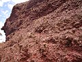 Scoria from Mount Napier
 -
 Close view of the volcanic rim
 -
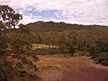
 Harmans Valley to Mount Napier
 -
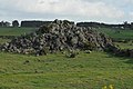 Tumuli - lava blisters


See also
 Australia portal
 Mountains portal
 Volcanoes portal


References
- ^ "Mount Napier". Gazetteer of Australia online. Geoscience Australia, Australian Government.
- ^ a b "Mount Napier State Park". Parks Victoria. Retrieved 22 February 2022.
- ^ Grimes, Ken (2013). "The Ages of Our Volcanoes" (PDF). Archived from the original (PDF) on 8 August 2014. Retrieved 5 August 2014.
- ^ Frankel, David; Major, Janine (2014). Kulin and Kurnai : Victorian Aboriginal life and customs. p. 138. ISBN 978-1326124779.
- ^ Grimes, Ken (2003). "The Tumuli" (PDF). Hamilton Field Naturalist Club. Retrieved 23 May 2017.
- ^ a b Bird, Rod. "Mammals and Birds of the Mount Napier State Park" (PDF). Retrieved 19 September 2012.
External links
- Mt Napier State Park
- Byaduk Caves
- v
- t
- e
- William (1,167 m or 3,829 ft)
- Difficult
- Wilson
- Zero (364 m or 1,194 ft)
| Bogong High Plains |
|
|---|---|
| Cathedral Range |
|
| Cobberas Range |
|
| Cobbler Plateau |
|
| Other |
|
mountain ranges
| Central Highlands |
|
|---|---|
| Dandenong Ranges |
|
| Pyrenees Ranges |
|
| Strzelecki Ranges |
|
| Other |
|
 | This article about a location in Victoria, Australia is a stub. You can help Wikipedia by expanding it. |
- v
- t
- e


