Pont-Canavese
Comune in Piedmont, Italy

Coat of arms
Location of Pont Canavese

45°25′N 7°36′E / 45.417°N 7.600°E / 45.417; 7.600
(1-1-2017)[2]
10085
Pont Canavese is a comune (municipality) in the Metropolitan City of Turin in the Italian region Piedmont, located about 40 kilometres (25 mi) north of Turin. It occupies a small fluvial plain between the rivers Orco and Soana: its names (Pont, derived from the Latin ad duos pontes, being the Franco-Provençal word for "bridge") derives from the series of bridges that were historically built here to cross those rivers.
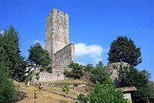
Pont Canavese borders the following municipalities: Ronco Canavese, Ingria, Frassinetto, Sparone, Chiesanuova, Cuorgnè and Alpette. Sights include the archaeological site of Santa Maria in Doblazio, the church of San Costanzo (1328) and a series of towers of medieval origins, once belonging to the local most powerful families.
References
Wikimedia Commons has media related to Pont Canavese.
External links
- Official website
- v
- t
- e
- Agliè
- Airasca
- Ala di Stura
- Albiano d'Ivrea
- Almese
- Alpette
- Alpignano
- Andezeno
- Andrate
- Angrogna
- Arignano
- Avigliana
- Azeglio
- Bairo
- Balangero
- Baldissero Canavese
- Baldissero Torinese
- Balme
- Banchette
- Barbania
- Bardonecchia
- Barone Canavese
- Beinasco
- Bibiana
- Bobbio Pellice
- Bollengo
- Borgaro Torinese
- Borgiallo
- Borgofranco d'Ivrea
- Borgomasino
- Borgone Susa
- Bosconero
- Brandizzo
- Bricherasio
- Brosso
- Brozolo
- Bruino
- Brusasco
- Bruzolo
- Buriasco
- Burolo
- Busano
- Bussoleno
- Buttigliera Alta
- Cafasse
- Caluso
- Cambiano
- Campiglione-Fenile
- Candia Canavese
- Candiolo
- Canischio
- Cantalupa
- Cantoira
- Caprie
- Caravino
- Carema
- Carignano
- Carmagnola
- Casalborgone
- Cascinette d'Ivrea
- Caselette
- Caselle Torinese
- Castagneto Po
- Castagnole Piemonte
- Castellamonte
- Castelnuovo Nigra
- Castiglione Torinese
- Cavagnolo
- Cavour
- Cercenasco
- Ceres
- Ceresole Reale
- Cesana Torinese
- Chialamberto
- Chianocco
- Chiaverano
- Chieri
- Chiesanuova
- Chiomonte
- Chiusa di San Michele
- Chivasso
- Ciconio
- Cintano
- Cinzano
- Cirié
- Claviere
- Coassolo Torinese
- Coazze
- Collegno
- Colleretto Castelnuovo
- Colleretto Giacosa
- Condove
- Corio
- Cossano Canavese
- Cuceglio
- Cumiana
- Cuorgnè
- Druento
- Exilles
- Favria
- Feletto
- Fenestrelle
- Fiano
- Fiorano Canavese
- Foglizzo
- Forno Canavese
- Frassinetto
- Front
- Frossasco
- Garzigliana
- Gassino Torinese
- Germagnano
- Giaglione
- Giaveno
- Givoletto
- Gravere
- Groscavallo
- Grosso
- Grugliasco
- Ingria
- Inverso Pinasca
- Isolabella
- Issiglio
- Ivrea
- La Cassa
- La Loggia
- Lanzo Torinese
- Lauriano
- Leinì
- Lemie
- Lessolo
- Levone
- Locana
- Lombardore
- Lombriasco
- Loranzè
- Luserna San Giovanni
- Lusernetta
- Lusigliè
- Macello
- Maglione
- Mappano
- Marentino
- Massello
- Mathi
- Mattie
- Mazzè
- Meana di Susa
- Mercenasco
- Mezzenile
- Mombello di Torino
- Mompantero
- Monastero di Lanzo
- Moncalieri
- Moncenisio
- Montaldo Torinese
- Montalenghe
- Montalto Dora
- Montanaro
- Monteu da Po
- Moriondo Torinese
- Nichelino
- Noasca
- Nole
- Nomaglio
- None
- Novalesa
- Oglianico
- Orbassano
- Orio Canavese
- Osasco
- Osasio
- Oulx
- Ozegna
- Palazzo Canavese
- Pancalieri
- Parella
- Pavarolo
- Pavone Canavese
- Pecetto Torinese
- Perosa Argentina
- Perosa Canavese
- Perrero
- Pertusio
- Pessinetto
- Pianezza
- Pinasca
- Pinerolo
- Pino Torinese
- Piobesi Torinese
- Piossasco
- Piscina
- Piverone
- Poirino
- Pomaretto
- Pont-Canavese
- Porte
- Pragelato
- Prali
- Pralormo
- Pramollo
- Prarostino
- Prascorsano
- Pratiglione
- Quagliuzzo
- Quassolo
- Quincinetto
- Reano
- Ribordone
- Riva presso Chieri
- Rivalba
- Rivalta di Torino
- Rivara
- Rivarolo Canavese
- Rivarossa
- Rivoli
- Robassomero
- Rocca Canavese
- Roletto
- Romano Canavese
- Ronco Canavese
- Rondissone
- Rorà
- Rosta
- Roure
- Rubiana
- Rueglio
- Salassa
- Salbertrand
- Salerano Canavese
- Salza di Pinerolo
- Samone
- San Benigno Canavese
- San Carlo Canavese
- San Colombano Belmonte
- San Didero
- San Francesco al Campo
- San Germano Chisone
- San Gillio
- San Giorgio Canavese
- San Giorio di Susa
- San Giusto Canavese
- San Martino Canavese
- San Maurizio Canavese
- San Mauro Torinese
- San Pietro Val Lemina
- San Ponso
- San Raffaele Cimena
- San Sebastiano da Po
- San Secondo di Pinerolo
- Sangano
- Sant'Ambrogio di Torino
- Sant'Antonino di Susa
- Santena
- Sauze d'Oulx
- Sauze di Cesana
- Scalenghe
- Scarmagno
- Sciolze
- Sestriere
- Settimo Rottaro
- Settimo Torinese
- Settimo Vittone
- Sparone
- Strambinello
- Strambino
- Susa
- Tavagnasco
- Turin
- Torrazza Piemonte
- Torre Canavese
- Torre Pellice
- Trana
- Traversella
- Traves
- Trofarello
- Usseaux
- Usseglio
- Vaie
- Valchiusa
- Val della Torre
- Val di Chy
- Valgioie
- Vallo Torinese
- Valperga
- Valprato Soana
- Varisella
- Vauda Canavese
- Venaria Reale
- Venaus
- Verolengo
- Verrua Savoia
- Vestignè
- Vialfrè
- Vidracco
- Vigone
- Villafranca Piemonte
- Villanova Canavese
- Villar Dora
- Villar Focchiardo
- Villar Pellice
- Villar Perosa
- Villarbasse
- Villareggia
- Villastellone
- Vinovo
- Virle Piemonte
- Vische
- Vistrorio
- Viù
- Volpiano
- Volvera
| Authority control databases |
|
|---|
 | This article on a location in the Province of Turin is a stub. You can help Wikipedia by expanding it. |
- v
- t
- e


