Historical site
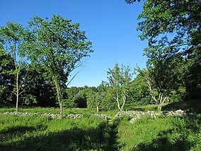
Cormier Woods is a 175-acre (71 ha) open space preserve and historic 18th-century farm complex in Uxbridge, Massachusetts, USA, within the Blackstone River Valley National Heritage Corridor. The property is named for James Cormier, the former owner of the property. It was acquired in 2008 by the land conservation non-profit organization The Trustees of Reservations.
The reservation includes 3 miles (4.8 km) of hiking trails, farmland, woodlots, wetlands, a farmhouse, barn and sheds. It is open to hiking, picnicking, cross country skiing and hunting (in season). The reservation trailhead is on Chapin Street in Uxbridge.[1]
References
- ^ "Cormier Woods". The Trustees of Reservationis. Retrieved 1 July 2021.
External links
- The Trustees of Reservations
- Cormier Woods trail map
|
|
|
|
|---|
Wildlife
Management Areas | |
|---|
Wildlife
Sanctuaries | - Billingsgate Island
- Carr Island
- E. Howe Forbush
- Egg Rock
- Grace A. Robson
- J.C. Phillips
- Knight
- Penikese Island
- Ram Island (Mattapoisett)
- Ram Island (Salisbury)
- Susan B. Minns
- Tarpaulin Cove
- Watatic Mountain
|
|---|
|
|
|
|---|
- Black Pond Bog
- Boat Meadow
- Francis Newhall Woods
- Grassy Pond
- Greene Swamp
- Halfway Pond Island
- Hawley Bog
- Hockomock Swamp
- Hoft Farm
- Homer-Watcha
- Katama Plains
- McElwain-Olsen
- Miacomet Moors
- Reed Brook
- Roger and Virginia Drury
- Sandy Neck
- David H. Smith Preserve and Fire Trail
- Stacy Mountain
- Tatkon
|
|
|
|
|
|
42°04′08″N 71°35′38″W / 42.06889°N 71.59389°W / 42.06889; -71.59389
 Category
 Commons


