Noon Hill and Shattuck Reservation

Massachusetts open space preserves
Noon Hill and Shattuck Reservation
Noon Hill
LocationNoon Hill Road
Medfield, Massachusetts, USA
Area449 acres (182 ha) combined
Established1959 and 1970
OperatorThe Trustees of Reservations
WebsiteNoon Hill and Shattuck

Noon Hill and Shattuck Reservation are adjacent open space preserves located in Medfield, Massachusetts. They are managed by the land conservation non-profit organization The Trustees of Reservations. The 200-mile (320 km) Bay Circuit Trail passes through both properties. The Town of Medfield owns conservation land adjacent to the properties.[1]

Noon Hill is a 204-acre (83 ha) open space preserve that offers 4.5 miles (7.2 km) of trails available for hiking, horseback riding, mountain biking, and cross country skiing.[2] Oak-hickory forest, wetlands, vernal pools, steep ravines, boulders, and rocky ledges characterize the preserve. The preserve is centered on 370-foot (110 m) Noon Hill, a prominent summit and scenic vista. Holt Pond, a constructed mill pond, is located on the property.

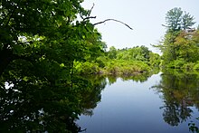
Shattuck Reservation is a 245-acre (99 ha) preserve along the Charles River. It consists of "a forested upland neck of oak and pine overlooking a wet meadow and red maple swamp." Stone walls demonstrate that the land was once used as pasture.[3]

History

Holt Pond

The rugged, rocky terrain of Noon Hill was formed via glacial action during the last ice age through glacial plucking and scouring. Holt Pond, the dammed flow of Sawmill Brook, was constructed circa 1764 to service colonial era mills. Other parts of the property were used as pasture land.[2]

Noon Hill was acquired in 1959 as a gift of W. K. Gilmore & Sons; additional land was given by other donors in 1960, 1963, and 1978.

Dwight's Causeway, at the northern end of Shattuck, was the site of a bridge that washed out in the 1938 New England hurricane. The Trustees acquired Shattuck in 1970.[4]

Recreation

Shattuck Reservation

The main trailhead and parking lot for both properties is located on Noon Hill Road in Medfield.[2] The properties may be reached on foot via the Bay Circuit Trail, a long-distance hiking trail that forms a 200-mile (320 km) arc around the suburban belt to the west of Boston. A canoe landing in the Shattuck Reservation allows visitors to arrive by boat.[3]

Distant view of Gillette Stadium from Noon Hill

A network of trails span the properties. Within the Noon Hill reservation, the Bay Circuit Trail passes over the summit of Noon Hill, where open ledges offer views of the landscape of neighboring Walpole, Norfolk, and Great Blue Hill. A new segment of the Bay Circuit Trail was created within the Shattuck Reservation in 2012 to reduce the distance that the trail followed Causeway Street.[5]

Advisories

"Authorized seasonal bow hunting" is allowed in the fall at both properties. Shooting ranges are located across the road from Noon Hill, and across the Charles River from Shattuck. According to the Trustees website, noise from the shooting ranges "can be very loud at times."[2][3]

Off-leash dogs are permitted at Shattuck only and as long as they are under control at all times. Dogs must be on leash at Noon Hill at all times. Mountain biking on official trails, is permitted.[3]

References

  1. ^ "Open Space and Recreation Plan". Town of Medfield. Retrieved 30 May 2023.
  2. ^ a b c d "Noon Hill". The Trustees of Reservations. Retrieved 6 July 2021.
  3. ^ a b c d "Shattuck Reservation". The Trustees of Reservations. Retrieved 30 May 2023.
  4. ^ Horan, Nancy. "Trustees of Reservations: Celebrating and Protecting Medfield's Special Places". Medfield Historical Society. Retrieved 30 May 2023.
  5. ^ "Map 9 - Sherborn, Medfield - BAY CIRCUIT TRAIL route" (PDF). Bay Circuit Trail. Retrieved 30 May 2023.

External links

Wikimedia Commons has media related to Noon Hill and Shattuck Reservation.
  • Noon Hill The Trustees of Reservations
  • Shattuck Reservation The Trustees of Reservations
  • Map of Noon Hill and Shattuck Reservation
  • Bay Circuit Trail
  • Bay Circuit Trail Map 9
  • Bay Circuit Trail description of Section 9
  • v
  • t
  • e
Protected areas of Massachusetts
National Historical Parks
National Historic Sites
Other National Park Service Units
National Wildlife Refuges
Wild and Scenic Rivers
Other Protected Areas
Parks
Reservations
Other
Wildlife
Management Areas
  • Agawam Lake
  • Agawam Mill Pond
  • Ashby
  • Ashfield Hawley
  • Attitash
  • Ayer Game Farm
  • Baddacook Pond
  • Bakers Pond
  • Bay Circuit Trail
  • Bearse Pond
  • Becket
  • Bennett
  • Birch Hill
  • Black Brook
  • Blackstone / West River
  • Bolton Flats
  • Boxboro Station
  • Brayton Point Salt Marsh
  • Breakneck Brook
  • Brewer Brook
  • Bullock Ledge
  • Burrage Pond
  • Canoe River
  • Catamount
  • Chalet
  • Chase Garden Creek Salt Marsh
  • Childs River
  • Chockalog Swamp
  • Church Homestead
  • Clapps Pond
  • Clinton Bluff
  • Concord River
  • Connecticut River
  • Cook Pond
  • Copicut
  • Coy Hill
  • Crane Pond
  • Cummington
  • Cusky Pond
  • Dartmoor Farm
  • Darwin Scott Memorial
  • Day Mountain
  • Deerfield River
  • Dogfish Bar Beach Coastal
  • Dolomite Ledges
  • Dunstable Brook
  • E. Kent Swift
  • Eagle Island
  • East Mountain
  • Eastham Salt Marsh
  • Elbow Meadow
  • English Salt Marsh
  • Eugene D. Moran
  • Facing Rock
  • Fairfield Brook
  • Farmington River
  • Fish Brook
  • Fisherville Pond
  • Fisk Forestdale Lot
  • Fisk Meadows
  • Five Mile River
  • Flagg Swamp
  • Flint Pond
  • Four Chimneys
  • Fox Den
  • Fox Island Salt Marsh
  • Frances A. Crane
  • George L. Darey Housatonic Valley
  • Glen Echo Lake
  • Gosnold
  • Grassy Pond (Dennis)
  • Grassy Pond (Plymouth)
  • Green River Access (Franklin County)
  • Green River (Berkshire County)
  • Greenfield River
  • Halfway Pond
  • Hamilton
  • Hancock
  • Harlow / Cooks Pond
  • Haskell Swamp
  • Hauk Swamp
  • Hawksnest State Park
  • Hawley
  • Head Of The Plains
  • Herman Covey
  • High Ridge
  • Hinsdale Flats
  • Hiram H. Fox
  • Hockomock Swamp
  • Hog Pond Lot
  • Honey Pot
  • Hoosatonic River
  • Hoosic River
  • Hop Brook
  • Housatonic River
  • Hubbard Brook
  • Hunting Hills
  • Hyannis Ponds
  • Ipswich River
  • John J. Kelly
  • Joint Base Cape Cod
  • Jug End
  • Jug End Fen
  • Kampoosa Fen
  • Katama Plains
  • Knops Pond
  • Konkapot River
  • Lackey Pond
  • Lake Lorraine
  • Lake Rohunta
  • Lake Snipatuit
  • Lake Warner
  • Lanesboro
  • Lawrence Brook
  • Lawrence Pond Lot
  • Leadmine
  • Leyden
  • Lilly Pond
  • Little Alum Pond
  • Long Sought For Pond
  • Maple Hill
  • Maple Springs
  • Martha Deering
  • Martin H. Burns
  • Mascuppic Lake
  • Mashpee Pine Barrens
  • Mashpee Pond Lot
  • Mashpee River
  • Mckinstry Brook
  • Meetinghouse Swamp
  • Merrill Pond
  • Miacomet Heath
  • Mill Brook Bogs
  • Mill River
  • Millers River
  • Mine Brook
  • Montague
  • Montague Plains
  • Moose Brook Access
  • Moose Brook
  • Moose Hill
  • Mossy Pond
  • Mount Watatic Reservation
  • Mt. Esther
  • Mt. Toby Highlands
  • Mt. Toby
  • Mt. Tom
  • Muddy Brook
  • Muddy Pond
  • Mulpus Brook
  • Nashua River
  • Natty Brook
  • Nemasket River
  • Nissitissit River
  • Noquochoke
  • Nordeen Marsh
  • North Brookfield
  • North Shore Salt Marsh
  • Northboro
  • Oakham
  • Olivers Pond
  • Orange
  • Otis
  • Packard Pond
  • Palmer
  • Pantry Brook
  • Pauchaug Brook
  • Peru
  • Peterson Swamp
  • Phillipston
  • Podunk Marsh
  • Poland Brook
  • Popple Camp
  • Popponesset Spit
  • Poutwater Pond
  • Powell Brook
  • Prince River
  • Provincetown Route 6 Corridor
  • Purchade Brook
  • Quaboag
  • Quacumquasit
  • Quag Pond Bog
  • Quashnet River
  • Quashnet Woods State Reservation
  • Quinapoxet River
  • Quinsigamond Marsh
  • Quisset
  • Raccoon Hill
  • Rainbow Beach
  • Red Brook
  • Richardson
  • Robbins Pond
  • Rochester
  • Rocky Gutter
  • Rowe
  • Salisbury Salt Marsh
  • Salisbury Salt Marsh WMA
  • Sandwich Game Farm
  • Sandy Pond
  • Satan's Kingdom
  • Savage Hill
  • Savoy
  • Sawmill River
  • Scorton Creek Coastal
  • SE Mass Bioreserve
  • Sevenmile River
  • Shattuck Brook
  • Sheperds Island
  • Shubael Pond
  • Sibley Brook
  • Sly Pond
  • South Barrier Beach
  • South Meadow Pond
  • South Shore Salt Marsh
  • South Triangle Pond
  • Southampton
  • Southwick
  • Spectacle Pond
  • Springhill Lot
  • Sputtermill Pond
  • Squannacook River
  • Stafford Hill
  • Sudbury River
  • Sunderland Islands
  • Taconic Mountain
  • Taunton River Access
  • Taunton River
  • Tekoa Mountain
  • Thad Ellis
  • Thayer Pond
  • Three Mile Pond
  • Townsend
  • Townsend Hill
  • Trapfall Brook
  • Triangle Pond
  • Tully Brook
  • Tully Mountain
  • Tully River
  • Wakeby Pond
  • Wales
  • Walnut Hill
  • Ware River
  • Warwick
  • Wendell
  • West Meadows
  • Westboro
  • Westfield River
  • Westfield
  • Weymouth Back River
  • Whately Great Swamp
  • Whately Ponds
  • Whately
  • Wilbraham Game Farm
  • William Forward
  • Williams River
  • Williamsburg
  • Winimusset
  • Wolf Swamp
Wildlife
Sanctuaries
  • Billingsgate Island
  • Carr Island
  • E. Howe Forbush
  • Egg Rock
  • Grace A. Robson
  • J.C. Phillips
  • Knight
  • Penikese Island
  • Ram Island (Mattapoisett)
  • Ram Island (Salisbury)
  • Susan B. Minns
  • Tarpaulin Cove
  • Watatic Mountain
  • Black Pond Bog
  • Boat Meadow
  • Francis Newhall Woods
  • Grassy Pond
  • Greene Swamp
  • Halfway Pond Island
  • Hawley Bog
  • Hockomock Swamp
  • Hoft Farm
  • Homer-Watcha
  • Katama Plains
  • McElwain-Olsen
  • Miacomet Moors
  • Reed Brook
  • Roger and Virginia Drury
  • Sandy Neck
  • David H. Smith Preserve and Fire Trail
  • Stacy Mountain
  • Tatkon
Other

42°09′53.2″N 71°19′06.6″W / 42.164778°N 71.318500°W / 42.164778; -71.318500