42°17′03″N 71°11′59″W / 42.28417°N 71.19972°W / 42.28417; -71.19972[1]| Area | 772 acres (312 ha)[2] |
|---|
| Elevation | 89 ft (27 m)[1] |
|---|
| Established | 1962 |
|---|
| Named for | State Senator Leslie B. Cutler |
|---|
| Operator | Massachusetts Department of Conservation and Recreation |
|---|
| Website | Cutler Park Reservation |
|---|
Cutler Park is a state-owned nature preserve and public recreation area that lies between Route 128/I-95 and the Charles River in Needham, Massachusetts. The state park's 772 acres (312 ha) contain the largest remaining freshwater marsh on the middle Charles River. Parts of its major trail run directly through the marsh via boardwalks; over 100 species of birds have been sighted here.[3] The park is part of a plan by the Town of Needham to connect 18 public areas by 35 proposed trails.[4] It is managed by the Massachusetts Department of Conservation and Recreation.[5]
History
Along the west side of Kendrick Pond remains the imprint where soil was removed in the 19th century to fill the area now known as the Back Bay in Boston. An extension of the railroad was added so the soil could be transported into Boston. Some of the old tracks are visible near the north entrance of the park on Kendrick Street. The large marsh in the park is not natural, but rather was created by flooding from the Silk Mill Dam in Newton Upper Falls in the 1890s. These wet areas were used in the past for wells and irrigation, and remains of filter ponds, ditches, and water systems are still present.[6] Land for the park was acquired by the state in 1962.[5]
Geography
The bulk of Cutler Park falls within the borders of Needham, Massachusetts. The southern end is part of Dedham; and the park also holds the strip of land on the Newton/Boston side of the Charles River running from Nahanton Street, Newton, south to the City of Boston's Millennium Park (part of West Roxbury). Much of the park's area is marsh or wetland, while forest makes up the rest and bears most of the trails. In two sections the Blue Heron Trail bears foot or bicycle traffic through the marsh on wooden boardwalks. At the park's north end, a trail goes around Kendrick Pond (also called Cutler Pond).[6] A railroad line, used primarily by the MBTA Commuter Rail, runs roughly east–west on a raised right-of-way through the southern half of the park. A trail runs adjacent to the right-of-way the entire width of the park, and a tunnel under the railroad provides access across it.[4]
Activities and amenities
The park contains trails suitable for walking, hiking, bird watching, mountain biking, and cross-country skiing. Challenging singletracks for mountain bikers are found between the pond and Route 128.[7] Fishing and canoeing are also options.[5]
Image gallery
-
Cutler Pond
-
Boardwalk across Great Plain
-
Swans in Cutler Pond
-
MBTA commuter tracks through park
-
Boaters in Charles River adjacent to park
-
Remains of old water supply facilities
-
Egret in the Charles River at Cutler Park
References
 Massachusetts portal
- ^ a b "Cutler Park". Geographic Names Information System. United States Geological Survey, United States Department of the Interior.
- ^ "Cutler Park Reservation". Department of Conservation and Recreation. Retrieved January 4, 2024.
- ^ "Cutler Park; Cutler Lake". eBird. Cornell Lab of Ornithology. Retrieved February 22, 2017.
- ^ a b "Town of Needham Trails Master Plan". Needham Trails Advisory Committee. November 2008. Retrieved March 4, 2015.
- ^ a b c "Cutler Park Reservation". MassParks. Executive Office of Energy and Environmental Affairs. Retrieved August 18, 2013.
- ^ a b "Cutler Park". Newton Park and Conservation Lands. Newton Conservators. Retrieved March 3, 2019.
- ^ Bill Boles. "Cutler Park Needham/Newton". New England Mountain Bike Association. Retrieved February 22, 2017.
External links
- Cutler Park Reservation Department of Conservation and Recreation
- Cutler Park Reservation Trail Map Department of Conservation and Recreation
- Newton Conservators
|
|
|
|
|---|
Wildlife
Management Areas | |
|---|
Wildlife
Sanctuaries | - Billingsgate Island
- Carr Island
- E. Howe Forbush
- Egg Rock
- Grace A. Robson
- J.C. Phillips
- Knight
- Penikese Island
- Ram Island (Mattapoisett)
- Ram Island (Salisbury)
- Susan B. Minns
- Tarpaulin Cove
- Watatic Mountain
|
|---|
|
|
|
|---|
- Black Pond Bog
- Boat Meadow
- Francis Newhall Woods
- Grassy Pond
- Greene Swamp
- Halfway Pond Island
- Hawley Bog
- Hockomock Swamp
- Hoft Farm
- Homer-Watcha
- Katama Plains
- McElwain-Olsen
- Miacomet Moors
- Reed Brook
- Roger and Virginia Drury
- Sandy Neck
- David H. Smith Preserve and Fire Trail
- Stacy Mountain
- Tatkon
|
|
|
|
|
|
|
|---|
| Coastal reservations | |
|---|
| River reservations | |
|---|
| Woodland reservations | |
|---|
| Heritage state parks | |
|---|
| Parkways and roads | |
|---|
|
 Cutler Pond
 Boardwalk across Great Plain
 Swans in Cutler Pond
 MBTA commuter tracks through park
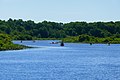 Boaters in Charles River adjacent to park
 Remains of old water supply facilities
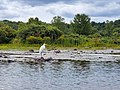 Egret in the Charles River at Cutler Park


 Category
 Commons


