National Register of Historic Places listings in Cherokee County, North Carolina
Map all coordinates using OpenStreetMap
Download coordinates as:
- KML
- GPX (all coordinates)
- GPX (primary coordinates)
- GPX (secondary coordinates)

This list includes properties and districts listed on the National Register of Historic Places in Cherokee County, North Carolina. Click the "Map of all coordinates" link to the right to view an online map of all properties and districts with latitude and longitude coordinates in the table below.[1]
Current listings
This National Park Service list is complete through NPS recent listings posted June 7, 2024.[2]
| [3] | Name on the Register | Image | Date listed[4] | Location | City or town | Description |
|---|---|---|---|---|---|---|
| 1 | Apalachia Hydroelectric Project |  | October 26, 2017 (#100001459) | Apalachia Dam Rd. 35°10′04″N 84°17′44″W / 35.167778°N 84.295556°W / 35.167778; -84.295556 (Apalachia Hydroelectric Project) | Murphy | |
| 2 | John C. Campbell Folk School Historic District |  | August 22, 1983 (#83001839) | Off U.S. Route 64 35°02′10″N 83°57′54″W / 35.036111°N 83.965°W / 35.036111; -83.965 (John C. Campbell Folk School Historic District) | Brasstown | |
| 3 | Cherokee County Courthouse |  | May 10, 1979 (#79001692) | 75 Peachtree Street 35°05′12″N 84°01′59″W / 35.086667°N 84.033056°W / 35.086667; -84.033056 (Cherokee County Courthouse) | Murphy | |
| 4 | John Franklin Cobb House |  | October 11, 1984 (#84000074) | U.S. Routes 19/129 35°00′07″N 84°05′04″W / 35.001944°N 84.084444°W / 35.001944; -84.084444 (John Franklin Cobb House) | Bell View | |
| 5 | Hiwassee Hydroelectric Project |  | August 11, 2017 (#100001460) | 600 Powerhouse Rd. 35°09′04″N 84°10′40″W / 35.151184°N 84.177658°W / 35.151184; -84.177658 (Hiwassee Hydroelectric Project) | Murphy | |
| 6 | Robert Lafayette Cooper House |  | September 5, 1990 (#90001372) | 70 Campbell St. 35°05′14″N 84°01′50″W / 35.087154°N 84.030507°W / 35.087154; -84.030507 (Robert Lafayette Cooper House) | Murphy | |
| 7 | Franklin Pierce Cover House |  | November 12, 1982 (#82001293) | 177 Wilson Street 35°12′07″N 83°49′37″W / 35.201893°N 83.826953°W / 35.201893; -83.826953 (Franklin Pierce Cover House) | Andrews | |
| 8 | First Baptist Church |  | September 14, 2002 (#02000962) | 101 Chestnut St. 35°12′00″N 83°49′31″W / 35.200090°N 83.825178°W / 35.200090; -83.825178 (First Baptist Church) | Andrews | |
| 9 | Harshaw Chapel and Cemetery | 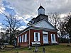 | April 5, 1984 (#84001979) | 150 Church Street 35°05′07″N 84°02′01″W / 35.085278°N 84.033611°W / 35.085278; -84.033611 (Harshaw Chapel and Cemetery) | Murphy | |
| 10 | Walker's Inn |  | August 19, 1975 (#75001247) | South of Andrews on NC 1505 off NC 19 and 1393 35°11′35″N 83°48′16″W / 35.193056°N 83.804444°W / 35.193056; -83.804444 (Walker's Inn) | Andrews |
Former listing
| [3] | Name on the Register | Image | Date listed | Date removed | Location | City or town | Description |
|---|---|---|---|---|---|---|---|
| 1 | Andrews Mound | Upload image | 1973 (#73002236) | 1975 | Address Restricted | Andrews | Burial mounds. Bulldozed in 1975 to build a shopping center. [5] |
See also
Wikimedia Commons has media related to National Register of Historic Places in Cherokee County, North Carolina.
- National Register of Historic Places listings in North Carolina
- List of National Historic Landmarks in North Carolina
References
- ^ The latitude and longitude information provided in this table was derived originally from the National Register Information System, which has been found to be fairly accurate for about 99% of listings. Some locations in this table may have been corrected to current GPS standards.
- ^ National Park Service, United States Department of the Interior, "National Register of Historic Places: Weekly List Actions", retrieved June 7, 2024.
- ^ a b Numbers represent an alphabetical ordering by significant words. Various colorings, defined here, differentiate National Historic Landmarks and historic districts from other NRHP buildings, structures, sites or objects.
- ^ The eight-digit number below each date is the number assigned to each location in the National Register Information System database, which can be viewed by clicking the number.
- ^ page 24
- v
- t
- e

by county
- Alamance
- Alexander
- Alleghany
- Anson
- Ashe
- Avery
- Beaufort
- Bertie
- Bladen
- Brunswick
- Buncombe
- Burke
- Cabarrus
- Caldwell
- Camden
- Carteret
- Caswell
- Catawba
- Chatham
- Cherokee
- Chowan
- Clay
- Cleveland
- Columbus
- Craven
- Cumberland
- Currituck
- Dare
- Davidson
- Davie
- Duplin
- Durham
- Edgecombe
- Forsyth
- Franklin
- Gaston
- Gates
- Graham
- Granville
- Greene
- Guilford
- Halifax
- Harnett
- Haywood
- Henderson
- Hertford
- Hoke
- Hyde
- Iredell
- Jackson
- Johnston
- Jones
- Lee
- Lenoir
- Lincoln
- Macon
- Madison
- Martin
- McDowell
- Mecklenburg
- Mitchell
- Montgomery
- Moore
- Nash
- New Hanover
- Northampton
- Onslow
- Orange
- Pamlico
- Pasquotank
- Pender
- Perquimans
- Person
- Pitt
- Polk
- Randolph
- Richmond
- Robeson
- Rockingham
- Rowan
- Rutherford
- Sampson
- Scotland
- Stanly
- Stokes
- Surry
- Swain
- Transylvania
- Tyrrell
- Union
- Vance
- Wake
- Warren
- Washington
- Watauga
- Wayne
- Wilkes
- Wilson
- Yadkin
- Yancey
| |
|---|---|
| Topics | |
| Lists by state |
|
| Lists by insular areas | |
| Lists by associated state | |
| Other areas | |
| Related | |
| |


Municipalities and communities of Cherokee County, North Carolina, United States | ||
|---|---|---|
County seat: Murphy | ||
| Towns | 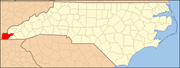 | |
| CDP | ||
| Other communities | ||
| Indian reservation | ||
| Footnotes | ‡This populated place also has portions in an adjacent county or counties | |
| ||


