National Register of Historic Places listings in Yadkin County, North Carolina
Map all coordinates using OpenStreetMap
Download coordinates as:
- KML
- GPX (all coordinates)
- GPX (primary coordinates)
- GPX (secondary coordinates)

This list includes properties and districts listed on the National Register of Historic Places in Yadkin County, North Carolina. Click the "Map of all coordinates" link to the right to view a Google map of all properties and districts with latitude and longitude coordinates in the table below.[1]
Current listings
This National Park Service list is complete through NPS recent listings posted June 7, 2024.[2]
| [3] | Name on the Register | Image | Date listed[4] | Location | City or town | Description |
|---|---|---|---|---|---|---|
| 1 | Davis Brothers Store |  | January 21, 1994 (#93001543) | E. Main St. N side, just E of jct. with Flint Hill Rd. 36°13′00″N 80°30′27″W / 36.216667°N 80.5075°W / 36.216667; -80.5075 (Davis Brothers Store) | East Bend | |
| 2 | Donnaha Site | Upload image | December 6, 1978 (#78001987) | Western side of the Yadkin River, east of East Bend[5] 36°13′53″N 80°26′29″W / 36.231389°N 80.441389°W / 36.231389; -80.441389 (Donnaha Site) | East Bend | |
| 3 | Durrett-Jarratt House | Upload image | May 23, 1997 (#97000474) | 0.35 miles SW of jct. of NC 1605 and NC 1569 36°07′08″N 80°29′59″W / 36.118889°N 80.499722°W / 36.118889; -80.499722 (Durrett-Jarratt House) | Enon | |
| 4 | Glenwood | 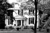 | August 13, 1979 (#79001766) | E of Enon on SR 1549 36°09′09″N 80°28′02″W / 36.1525°N 80.467222°W / 36.1525; -80.467222 (Glenwood) | Enon | Plantation estate with Greek Revival house from 1851 |
| 5 | Morse and Wade Building | Upload image | April 6, 2005 (#05000269) | 100 E. Main St. 36°12′59″N 80°30′27″W / 36.216389°N 80.5075°W / 36.216389; -80.5075 (Morse and Wade Building) | East Bend | |
| 6 | Richmond Hill Law School |  | October 15, 1970 (#70000483) | North of Richmond Hill on SR 1530 36°16′04″N 80°36′46″W / 36.267667°N 80.612908°W / 36.267667; -80.612908 (Richmond Hill Law School) | Richmond Hill | |
| 7 | Second Yadkin County Jail |  | July 21, 1988 (#88001113) | 241 E. Hemlock St. 36°08′09″N 80°39′23″W / 36.135958°N 80.656447°W / 36.135958; -80.656447 (Second Yadkin County Jail) | Yadkinville | |
| 8 | White House | Upload image | June 1, 1982 (#82003534) | Shallowford Rd. 36°05′01″N 80°31′43″W / 36.083611°N 80.528611°W / 36.083611; -80.528611 (White House) | Huntsville |
See also
Wikimedia Commons has media related to National Register of Historic Places in Yadkin County, North Carolina.
- National Register of Historic Places listings in North Carolina
- List of National Historic Landmarks in North Carolina
References
- ^ The latitude and longitude information provided in this table was derived originally from the National Register Information System, which has been found to be fairly accurate for about 99% of listings. Some locations in this table may have been corrected to current GPS standards.
- ^ National Park Service, United States Department of the Interior, "National Register of Historic Places: Weekly List Actions", retrieved June 7, 2024.
- ^ Numbers represent an alphabetical ordering by significant words. Various colorings, defined here, differentiate National Historic Landmarks and historic districts from other NRHP buildings, structures, sites or objects.
- ^ The eight-digit number below each date is the number assigned to each location in the National Register Information System database, which can be viewed by clicking the number.
- ^ Master Site Record, Research Laboratories of Archaeology, University of North Carolina at Chapel Hill, n.d. Accessed 2014-06-23.
- v
- t
- e

by county
- Alamance
- Alexander
- Alleghany
- Anson
- Ashe
- Avery
- Beaufort
- Bertie
- Bladen
- Brunswick
- Buncombe
- Burke
- Cabarrus
- Caldwell
- Camden
- Carteret
- Caswell
- Catawba
- Chatham
- Cherokee
- Chowan
- Clay
- Cleveland
- Columbus
- Craven
- Cumberland
- Currituck
- Dare
- Davidson
- Davie
- Duplin
- Durham
- Edgecombe
- Forsyth
- Franklin
- Gaston
- Gates
- Graham
- Granville
- Greene
- Guilford
- Halifax
- Harnett
- Haywood
- Henderson
- Hertford
- Hoke
- Hyde
- Iredell
- Jackson
- Johnston
- Jones
- Lee
- Lenoir
- Lincoln
- Macon
- Madison
- Martin
- McDowell
- Mecklenburg
- Mitchell
- Montgomery
- Moore
- Nash
- New Hanover
- Northampton
- Onslow
- Orange
- Pamlico
- Pasquotank
- Pender
- Perquimans
- Person
- Pitt
- Polk
- Randolph
- Richmond
- Robeson
- Rockingham
- Rowan
- Rutherford
- Sampson
- Scotland
- Stanly
- Stokes
- Surry
- Swain
- Transylvania
- Tyrrell
- Union
- Vance
- Wake
- Warren
- Washington
- Watauga
- Wayne
- Wilkes
- Wilson
- Yadkin
- Yancey
| |
|---|---|
| Topics | |
| Lists by state |
|
| Lists by insular areas | |
| Lists by associated state | |
| Other areas | |
| Related | |
| |


