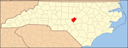
National Register of Historic Places listings in Lee County, North Carolina
Map all coordinates using OpenStreetMap
Download coordinates as:
- KML
- GPX (all coordinates)
- GPX (primary coordinates)
- GPX (secondary coordinates)

This list includes properties and districts listed on the National Register of Historic Places in Lee County, North Carolina. Click the "Map of all coordinates" link to the right to view an online map of all properties and districts with latitude and longitude coordinates in the table below.[1]
Current listings
This National Park Service list is complete through NPS recent listings posted May 17, 2024.[2]
| [3] | Name on the Register[4] | Image | Date listed[5] | Location | City or town | Description |
|---|---|---|---|---|---|---|
| 1 | Buffalo Presbyterian Church and Cemeteries |  | February 5, 1999 (#99000090) | 1333 Carthage St. 35°27′40″N 79°11′37″W / 35.461111°N 79.193611°W / 35.461111; -79.193611 (Buffalo Presbyterian Church and Cemeteries) | Sanford | |
| 2 | Downtown Sanford Historic District |  | September 28, 1985 (#85002561) | Roughly bounded by Gordon St., Horner Blvd., Cole and Chatham Sts.; also roughly bounded by South Horner Blvd, Cole St., Maple Ave., South and North First Sts., Norfolk-Southern Railway tracks, Charlotte Ave., McIver St., North Moore St., Gordon St. 35°28′49″N 79°10′42″W / 35.480278°N 79.178333°W / 35.480278; -79.178333 (Downtown Sanford Historic District) | Sanford | Second set of addresses represent a boundary change approved August 16, 2021 |
| 3 | East Sanford Historic District |  | December 28, 2010 (#10001096) | Bounded roughly by Charlotte Ave., Goldsboro Ave., N. 1st St., S. 2nd St., and S. 8th St. 35°28′48″N 79°10′08″W / 35.480000°N 79.168889°W / 35.480000; -79.168889 (East Sanford Historic District) | Sanford | |
| 4 | Endor Iron Furnace | Upload image | August 13, 1974 (#74001358) | SE of Cumnock 35°33′01″N 79°13′28″W / 35.550278°N 79.224444°W / 35.550278; -79.224444 (Endor Iron Furnace) | Cumnock | |
| 5 | Euphronia Presbyterian Church |  | May 26, 1994 (#94000527) | 3800 Steel Bridge Rd. 35°28′17″N 79°20′51″W / 35.471389°N 79.3475°W / 35.471389; -79.3475 (Euphronia Presbyterian Church) | Sanford | |
| 6 | Farish-Lambeth House | Upload image | March 1, 2002 (#02000111) | 6308 Deep River Rd. 35°36′52″N 79°07′00″W / 35.614339°N 79.116658°W / 35.614339; -79.116658 (Farish-Lambeth House) | Sanford | |
| 7 | Obediah Farrar House | Upload image | August 18, 1993 (#93000728) | 9910 Barringer Rd. 35°36′07″N 79°04′27″W / 35.601944°N 79.074167°W / 35.601944; -79.074167 (Obediah Farrar House) | Haywood | |
| 8 | Former Sanford High School |  | November 29, 1995 (#95001400) | 507 N. Steele St. 35°29′08″N 79°11′04″W / 35.485556°N 79.184444°W / 35.485556; -79.184444 (Former Sanford High School) | Sanford | |
| 9 | Hawkins Avenue Historic District | 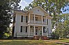 | July 5, 2000 (#00000771) | Roughly bounded by Hill Ave., First St., Charlotte Ave., and Horner Blvd. 35°29′10″N 79°10′50″W / 35.486111°N 79.180556°W / 35.486111; -79.180556 (Hawkins Avenue Historic District) | Sanford | |
| 10 | Lee Avenue Historic District |  | September 6, 2002 (#02000944) | Roughly along Lee Avenue, W. Main St., S. Academy St., and W. Raleigh St. 35°27′19″N 79°09′12″W / 35.455389°N 79.153353°W / 35.455389; -79.153353 (Lee Avenue Historic District) | Sanford | |
| 11 | Lee County Courthouse |  | May 10, 1979 (#79001729) | Horner Blvd., between Courtland and McIntosh Sts. 35°28′01″N 79°09′49″W / 35.466944°N 79.163611°W / 35.466944; -79.163611 (Lee County Courthouse) | Sanford | |
| 12 | Lee County Training School | 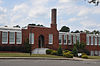 | December 28, 2000 (#00001551) | 806 S. Vance St. 35°28′25″N 79°10′58″W / 35.473611°N 79.182778°W / 35.473611; -79.182778 (Lee County Training School) | Sanford | |
| 13 | John D. McIver Farm |  | August 18, 1993 (#93000729) | 2007 Windmill Dr. 35°29′38″N 79°12′30″W / 35.493889°N 79.208333°W / 35.493889; -79.208333 (John D. McIver Farm) | Sanford | |
| 14 | Railroad House | 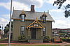 | January 29, 1973 (#73001355) | Carthage St. at Hawkins Ave. 35°28′50″N 79°10′39″W / 35.480556°N 79.1775°W / 35.480556; -79.1775 (Railroad House) | Sanford | |
| 15 | Rosemount-McIver Park Historic District |  | March 21, 1997 (#97000255) | Roughly bounded by N. Horner Blvd., N. Vance and Carthage Sts. 35°28′50″N 79°11′09″W / 35.480556°N 79.185833°W / 35.480556; -79.185833 (Rosemount-McIver Park Historic District) | Sanford | |
| 16 | Sanford Tobacco Company Redrying Plant and Warehouse | Upload image | August 27, 2019 (#100004323) | 521 Wicker St. 35°28′35″N 79°11′01″W / 35.4763°N 79.1837°W / 35.4763; -79.1837 (Sanford Tobacco Company Redrying Plant and Warehouse) | Sanford | |
| 17 | Seaboard Milling Company |  | May 2, 2002 (#02000440) | 202 Hickory Ave. 35°28′41″N 79°10′22″W / 35.478056°N 79.172778°W / 35.478056; -79.172778 (Seaboard Milling Company) | Sanford | |
| 18 | Temple Theatre |  | September 8, 1983 (#83001895) | 120 Carthage St. 35°28′52″N 79°10′44″W / 35.481111°N 79.178889°W / 35.481111; -79.178889 (Temple Theatre) | Sanford |
See also
Wikimedia Commons has media related to National Register of Historic Places in Lee County, North Carolina.
- National Register of Historic Places listings in North Carolina
- List of National Historic Landmarks in North Carolina
References
- ^ The latitude and longitude information provided in this table was derived originally from the National Register Information System, which has been found to be fairly accurate for about 99% of listings. Some locations in this table may have been corrected to current GPS standards.
- ^ National Park Service, United States Department of the Interior, "National Register of Historic Places: Weekly List Actions", retrieved May 17, 2024.
- ^ Numbers represent an alphabetical ordering by significant words. Various colorings, defined here, differentiate National Historic Landmarks and historic districts from other NRHP buildings, structures, sites or objects.
- ^ "National Register Information System". National Register of Historic Places. National Park Service. April 24, 2008.
- ^ The eight-digit number below each date is the number assigned to each location in the National Register Information System database, which can be viewed by clicking the number.
- v
- t
- e

by county
- Alamance
- Alexander
- Alleghany
- Anson
- Ashe
- Avery
- Beaufort
- Bertie
- Bladen
- Brunswick
- Buncombe
- Burke
- Cabarrus
- Caldwell
- Camden
- Carteret
- Caswell
- Catawba
- Chatham
- Cherokee
- Chowan
- Clay
- Cleveland
- Columbus
- Craven
- Cumberland
- Currituck
- Dare
- Davidson
- Davie
- Duplin
- Durham
- Edgecombe
- Forsyth
- Franklin
- Gaston
- Gates
- Graham
- Granville
- Greene
- Guilford
- Halifax
- Harnett
- Haywood
- Henderson
- Hertford
- Hoke
- Hyde
- Iredell
- Jackson
- Johnston
- Jones
- Lee
- Lenoir
- Lincoln
- Macon
- Madison
- Martin
- McDowell
- Mecklenburg
- Mitchell
- Montgomery
- Moore
- Nash
- New Hanover
- Northampton
- Onslow
- Orange
- Pamlico
- Pasquotank
- Pender
- Perquimans
- Person
- Pitt
- Polk
- Randolph
- Richmond
- Robeson
- Rockingham
- Rowan
- Rutherford
- Sampson
- Scotland
- Stanly
- Stokes
- Surry
- Swain
- Transylvania
- Tyrrell
- Union
- Vance
- Wake
- Warren
- Washington
- Watauga
- Wayne
- Wilkes
- Wilson
- Yadkin
- Yancey
| |
|---|---|
| Topics | |
| Lists by state |
|
| Lists by insular areas | |
| Lists by associated state | |
| Other areas | |
| Related | |
| |