National Register of Historic Places listings in Montgomery County, North Carolina
Map all coordinates using OpenStreetMap
Download coordinates as:
- KML
- GPX (all coordinates)
- GPX (primary coordinates)
- GPX (secondary coordinates)

This list includes properties and districts listed on the National Register of Historic Places in Montgomery County, North Carolina. Click the "Map of all coordinates" link to the right to view an online map of all properties and districts with latitude and longitude coordinates in the table below.[1]
Current listings
This National Park Service list is complete through NPS recent listings posted June 7, 2024.[2]
| [3] | Name on the Register | Image | Date listed[4] | Location | City or town | Description |
|---|---|---|---|---|---|---|
| 1 | Hotel Troy | 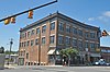 | August 23, 2006 (#06000720) | Northwestern corner of the junction of N. Main and Smitherman Sts. 35°21′45″N 79°53′44″W / 35.3625°N 79.895556°W / 35.3625; -79.895556 (Hotel Troy) | Troy | A historic commercial building located built in 1908-1909 |
| 2 | Montgomery County Courthouse |  | May 10, 1979 (#79001737) | E. Main St. between S. Main and S. Pearl Sts. 35°21′29″N 79°53′36″W / 35.358056°N 79.893333°W / 35.358056; -79.893333 (Montgomery County Courthouse) | Troy | A historic courthouse, designed by the noted architectural firm of Benton & Benton and built in 1921. |
| 3 | Mount Carmel Presbyterian Church and Cemetery | Upload image | December 19, 2019 (#100004795) | 1367 Clayton Carriker Rd. 35°10′25″N 79°45′23″W / 35.1735°N 79.7563°W / 35.1735; -79.7563 (Mount Carmel Presbyterian Church and Cemetery) | Norman | Extends into Richmond County. |
| 4 | Mount Gilead Downtown Historic District |  | December 23, 2005 (#05001447) | Main St. from First Ave. to 106 and 117 S. Main St., and the 100 block of W. Allenton St. 35°12′54″N 80°00′07″W / 35.214994°N 80.002061°W / 35.214994; -80.002061 (Mount Gilead Downtown Historic District) | Mount Gilead | A national historic district that encompasses 25 contributing buildings in the central business district of Mount Gilead. |
| 5 | Site 31Mg22 | Upload image | August 5, 1985 (#85001750) | Eastern side of the Yadkin River, east of Badin[5] 35°23′45″N 80°04′12″W / 35.395833°N 80.070000°W / 35.395833; -80.070000 (Site 31Mg22) | Badin | A historic archaeological site with remains from the Archaic period in North America. |
| 6 | Star Historic District |  | September 9, 2013 (#13000699) | Roughly bounded by College, 1st, and Dameron Sts. 35°24′13″N 79°47′04″W / 35.403611°N 79.784444°W / 35.403611; -79.784444 (Star Historic District) | Star | Encompasses 90 contributing properties: 85 buildings, 2 sites, and 3 structures |
| 7 | Town Creek Indian Mound |  | October 15, 1966 (#66000594) | Western side of the Little River, southeast of Mount Gilead[5] 35°10′57″N 79°55′46″W / 35.182500°N 79.929444°W / 35.182500; -79.929444 (Town Creek Indian Mound) | Mount Gilead | A prehistoric Native American archaeological site whose main features are a platform mound with a surrounding village and wooden defensive palisade. The site was built by the Pee Dee people. |
| 8 | Troy Residential Historic District |  | August 23, 2006 (#06000719) | Eastern side of N. Main St., from one lot north of Chestnut St. to one lot north of Blair St., and 105 Blair St. 35°21′38″N 79°53′37″W / 35.360556°N 79.893611°W / 35.360556; -79.893611 (Troy Residential Historic District) | Troy | A national historic district that encompasses five contributing dwellings in a residential section of Troy. |
See also
Wikimedia Commons has media related to National Register of Historic Places in Montgomery County, North Carolina.
- National Register of Historic Places listings in North Carolina
- List of National Historic Landmarks in North Carolina
References
- ^ The latitude and longitude information provided in this table was derived originally from the National Register Information System, which has been found to be fairly accurate for about 99% of listings. Some locations in this table may have been corrected to current GPS standards.
- ^ National Park Service, United States Department of the Interior, "National Register of Historic Places: Weekly List Actions", retrieved June 7, 2024.
- ^ Numbers represent an alphabetical ordering by significant words. Various colorings, defined here, differentiate National Historic Landmarks and historic districts from other NRHP buildings, structures, sites or objects.
- ^ The eight-digit number below each date is the number assigned to each location in the National Register Information System database, which can be viewed by clicking the number.
- ^ a b Master Site Record, Research Laboratories of Archaeology, University of North Carolina at Chapel Hill, n.d. Accessed 2014-06-23.
- v
- t
- e

by county
- Alamance
- Alexander
- Alleghany
- Anson
- Ashe
- Avery
- Beaufort
- Bertie
- Bladen
- Brunswick
- Buncombe
- Burke
- Cabarrus
- Caldwell
- Camden
- Carteret
- Caswell
- Catawba
- Chatham
- Cherokee
- Chowan
- Clay
- Cleveland
- Columbus
- Craven
- Cumberland
- Currituck
- Dare
- Davidson
- Davie
- Duplin
- Durham
- Edgecombe
- Forsyth
- Franklin
- Gaston
- Gates
- Graham
- Granville
- Greene
- Guilford
- Halifax
- Harnett
- Haywood
- Henderson
- Hertford
- Hoke
- Hyde
- Iredell
- Jackson
- Johnston
- Jones
- Lee
- Lenoir
- Lincoln
- Macon
- Madison
- Martin
- McDowell
- Mecklenburg
- Mitchell
- Montgomery
- Moore
- Nash
- New Hanover
- Northampton
- Onslow
- Orange
- Pamlico
- Pasquotank
- Pender
- Perquimans
- Person
- Pitt
- Polk
- Randolph
- Richmond
- Robeson
- Rockingham
- Rowan
- Rutherford
- Sampson
- Scotland
- Stanly
- Stokes
- Surry
- Swain
- Transylvania
- Tyrrell
- Union
- Vance
- Wake
- Warren
- Washington
- Watauga
- Wayne
- Wilkes
- Wilson
- Yadkin
- Yancey
| |
|---|---|
| Topics | |
| Lists by state |
|
| Lists by insular areas | |
| Lists by associated state | |
| Other areas | |
| Related | |
| |


Municipalities and communities of Montgomery County, North Carolina, United States | ||
|---|---|---|
County seat: Troy | ||
| Towns |  | |
| Unincorporated communities | ||
| ||


